Bob McDavitt's ideas for sailing around the South Pacific.
Disclaimer: Weather is a mix of pattern and chaos; these ideas are from the
patterned world.
Compiled Sunday 29 August 2021
SPCZ The South Pacific convergence zone
The SPCZ has two main drivers:
A: HIGH "A" that is located west of South America (I call it the Andes High
because it is held in place by the Andes Mountain range). It is quasi
stationary, just like the High between California and Hawaii, and also has a
gyre that is collecting a rubbish heap just as badly especially about
Henderson/Pitcairn Islands see
blogs.fco.gov.uk/lauraclarke/2018/04/10/henderson-island-plastic-pollution-i
n-paradise/).
B: The HIGHS that migrate along around 30 South from off Australia eastwards
into the Pacific.
What is happening is that the air that rotates around HIGH "A" produces a
northeast flow over the Marquises to Tahiti area and this converges into the
south/southeasterly air flow that is produced on the leading eastern and
northern sides of the "B" Highs .
This produces a convergence zone that stretches roughly from Solomons
islands to Southern Cooks.
Things to know about the SPCZ
1: The SPCZ has an annual cycle, going more to the north in winter and more
to the south in summer.
2: It also gets tugged northwards in an El Nino and southwards in a La Nina.
3: There is a pulse of extra convections that travels eastwards along it
around once every 3 to 6 weeks calls the MJO or Madden Julian Oscillation -
powerful enough to trigger tropical cyclones during summer.
4: The strength and position of the SPCZ is constantly changing with A and
B.
5: Around once a month or so an extra strong B High with a central pressure
over 1030 hPa pushes the isobars on its north side closer together making
what I call a SQUASH ZONE of enhanced trade winds in the tropics. This
squash zone travels eastwards with the Highs. This is called Bogi walu in
Fiji or Aho Valo in Tonga or Mara'umu in French Polynesia.
6: And it can become extra squally with the help of passing troughs that
follow the migration of lows in the Southern Ocean.
Read more about it at en.wikipedia.org/wiki/South_Pacific_convergence_zone
When sailing from Tahiti to Fiji, an encounter with the SPCZ is inevitable
and may be considered as a rite of passage. The trick is to work out in
advance some waypoints that avoid its nastier parts. This requires skill
obtained from practice. Global computer models tend to average out this
convergence and show it as a misleading zone of quieter winds, whereas it
can be squally.
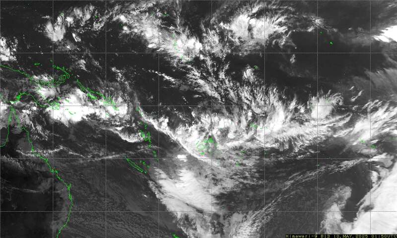
I have found that the easiest way to determine the position and severity of
the SPCZ is to watch satellite imagery (IR imagery shows the squalls). If
you can receive small sized emails at sea, you can download small sized
satellite images as follows
Send an email to query@saildocs.com (no subject needed) with one of the
following messages:
-> Infrared image 140E to 145W and from 10N to 35S updated every 10 minute
(46Kb).
SEND https://www.y2ksail.com/himawari/latest-SpacificLarge-small.jpg
-> Infrared image 140E to 160W and from 0S to 25S updated every 10 minutes
(40kb).
SEND https://www.y2ksail.com/himawari/latest-pacific3-small.jpg
-> FIJI Infrared image updated every 10 minutes (15Kb)
SEND https://www.y2ksail.com/himawari/latest-fiji-small.jpg
I recommend that you test these and check out the y2ksail.com web site
before departure from Tahiti. Also, to help decide what the SPCZ may do for
the next few says I use the 5-day rain accumulation parameter (e.g., on
windy.com)
TROPICS
Hurricane NORA is making landfall over Baja California, and Hurricane IDA is
heading for New Orleans,
after slamming Cuba. Tropical Depression TEN is heading north in mid
Atlantic.
WEATHER ZONES
SPCZ=South Pacific Convergence zone.
The SPCZ stretches from Solomona to Tuvalu to Samoa to Southern Cooks.
Trough from the southwest is expected to reach south of Southern Cooks by
mid-week and then form a low near 40S that will travel off to southeast.
HIGHS and LOWS
HIGH 1024 near 35S160W tonight is moving off to the east. High 1024 in North
Tasman Sea for Tuesday to Thursday with a squash zone of elevated trade
winds in Coral Sea strait.
LOW 1002 in mid-Tasman tonight contains thundery showers that are fading. It
is expected to travel NE to Auckland by Tuesday and then to north of NZ and
fade away by end of week.
HIGH south of NZ is expected to travel northeast and build to over 1036 east
of NZ by midweek and then to 35S 160W by end of the week. It is expected to
bring a strong squash zone between southern Cooks and southern Tonga from
the weekend. Avoid.
>>>>>>>>>>>>>>>>>>>>>>>>>>>>>>>>>>>>>>>>>
If you would like more detail for your voyage, then check metbob.com to see
what I offer.
Or Facebook at /www.facebook.com/metbobnz/
Weathergram with graphics is at metbob.wordpress.com (subscribe/unsubscribe
at bottom).
Weathergram archive (with translator) is at weathergram.blogspot.co.nz.
Contact is bob@metbob.com or txt 64277762212
>>>>>>>>>>>>>>>>>>>>>>>>>>>>>>>>>>>>>>>>>
29 August 2021
22 August 2021
Bob Blog 22 Aug
Bob McDavitt's ideas for sailing around the South Pacific.
Disclaimer: Weather is a mix of pattern and chaos; these ideas are from the
patterned world.
Compiled Sunday 22 August 2021
BREAKERS (on the coast) and swimming
Usually, it is the slope of the beach that determines the type of breakers:
Spilling, plunging or surging. These notes are from
www.seafriends.org.nz/oceano/waves.htm
. Spilling breakers: result from waves of low steepness (long period swell)
over gentle slopes. They cause rows of breakers, rolling towards the beach.
Such breakers gradually transport water towards the beach during groups of
high waves. Rips running back to sea, transport this water away from the
beach during groups of low waves. When caught swimming in a rip, do not
attempt to swim back to shore because such rips can be very strong (up to 8
km/hr). Swim parallel to the beach towards where the waves are highest. This
is where water moves towards the beach. The next group of tall waves should
assist you to swim back to shore. However, when launching (rescue) boats,
this is best done in a rip zone.
. Plunging breakers: result from steeper waves over moderate slopes. The
slope of a beach is not constant but may change with the tide. Some beaches
are steep toward high tide, others toward low tide. A plunging breaker is
dangerous for swimmers because its intensity is greatly augmented by
backwash from its predecessor. This strong backwash precludes easy exit from
the breaker zone, particularly for divers. Often a steep bank of loose sand
prevents one from standing upright. In order to exit safely, wait for a
group of low waves.
. Surging breakers: occur where the beach slope exceeds wave steepness. The
wave does not really curl and break but runs up against the shore while
producing foam and large surges of water. Such places are dangerous for
swimmers because the rapidly moving water can drag swimmers over the rocks.
When waves break, their energy is absorbed and converted to heat. The
gentler the slope of the beach, the more energy is converted. Steep slopes
such as rocky shores do not break waves much but do reflect them back to
sea, which 'shelters' marine life.
TROPICS
The latest cyclone activity report is at tropic.ssec.wisc.edu and Tropical
Cyclone Potential is from www.ssd.noaa.gov/PS/TROP/TCFP/index.html
It has been a busy week in the tropics. GRACE brought damaging winds to east
coast of Mexico, killing eight people. FRED brought flooding to North
Carolina, killing at least 2. The remains of LINDA are passing by to north
of Hawaii tonight. HENRI is heading for New York and New England, and OMAIS
is heading for South Korea. There is also a strong potential for possible
formation across the North Atlantic.
WEATHER ZONES
SPCZ=South Pacific Convergence zone.
The SPCZ is expected to build and stretch from Solomona to Tuvalu to Samoa
to Southern Cooks.
Trough south of Southern Cooks expected to form a low near 25S south of
Palmerston/Aitutaki that will travel off to southeast.
HIGHS and LOWS
HIGH over 1034 east of NZ and north of Chatham Island is a slow-moving block
and should take all week to travel NE from 43S to 33S.
LOW down to below 994 forming off Newcastle on Mon/Tue and travel across
Tasman Sea and then stall and fade west of the North Island this weekend
(due the blocking High).
Then by Friday a multi-centred HIGH is expected to travel east with #1
centre to SE of Tasmania and #2 over New South Wales. These should continue
east with #1 going around south of South Island and to east of South Island
next week, and with #2 fading in north Tasman Sea.
Looks like we may be having more dominant HIGHS in Tasman Sea over the next
few weeks, good tropical trade winds.
>>>>>>>>>>>>>>>>>>>>>>>>>>>>>>>>>>>>>>>>>
If you would like more detail for your voyage, then check metbob.com to see
what I offer.
Or Facebook at /www.facebook.com/metbobnz/
Weathergram with graphics is at metbob.wordpress.com (subscribe/unsubscribe
at bottom).
Weathergram archive (with translator) is at weathergram.blogspot.co.nz.
Contact is bob@metbob.com or txt 64277762212
>>>>>>>>>>>>>>>>>>>>>>>>>>>>>>>>>>>>>>>>>>>>>>>>>>>>>>>
21 August 2021
Whitehat Monthly SEO plans for your business
Hi there
I have just checked your site for the ranking keywords and found that you
could use a nice boost in the SEO trend and the organic visibility
If interested in getting more out of your online business, kindly hit reply
thanks and regards
Mike
I have just checked your site for the ranking keywords and found that you
could use a nice boost in the SEO trend and the organic visibility
If interested in getting more out of your online business, kindly hit reply
thanks and regards
Mike
15 August 2021
Monthly SEO Plans
Just checked your website and it could really use a boost
If you ever need Google updates free whitehat SEO plans, we are the right
team for you
Results oriented monthly plans to make your SEO trend climb like never
before
https://conversion-seo.co/seo-packages/
Unsubscribe:
please send a blank email to RonaldLilly7162@gmail.com
you will be automatically unsubscribed
Bob Blog 15Aug
Bob McDavitt's ideas for sailing around the South Pacific.
Disclaimer: Weather is a mix of pattern and chaos; these ideas are from the
patterned world.
Compiled Sunday 15 August 2021
More about waves
Last week I mentioned that shorter period waves are steeper and less
manageable.
I also mentioned that a sharply inclined seabed encourages breaking waves.
You can feel this increased choppiness when approaching land and crossing
the continental shelf.
This requires further explanation,
1. As you approach land, the swell arriving from the open ocean
interacts with the reflections of waves that bounce (rather than break) on
the coast, and this produces a diffraction pattern and increased choppiness.
1) There is usually a difference in the height of sea level on either
side of a continental shelf. This is maintained by strong ocean surface
currents sometimes as a series of eddies. When these currents flow against
the wind the waves that are produced are made steeper. A knot of current
builds the wave height up as much as a 10 knot increase in wind. =
I had a few readers reply to lat week's blog with stories of their own
encounter with steepening seas.
Rory recalls being off the Portuguese coast on a winter yacht delivery in
the 90s. Sailing south into a southerly gale, we tried going into the coast
to get some relief. Nope, inshore conditions were worse, so we headed back
to the ocean, As we crossed the continental shelf we sailed over two of the
biggest waves I have seen in 40 years of sailing. they were two very
organised swells that stretches as far as could be seen in both directions.
The first was just a very steep and impressive swell. But the second was
breaking at various points along its length, big enough to roll us.
Fortunately, we were between the breaking sections.
Stan writes about a trip across the Tasman Sea in March 2019. Finally
approaching land after a five-day passage, on a moon-less night and with
seasick crew, and being on the helm for over 12 hours, we continued
(doggedly) directly westwards to get ashore. But increasing wind from the
north and a strong current from the south meant a steepening sea. In
daylight we realised the sea state and altered course to the south so that
the swell was behind us. The sea would suddenly settle down, and then build
again dramatically. In retrospect we realised this was due to our transiting
areas with less current. As the waves settled in those area, we turned
westward towards Sydney. It was during one of these periods going west that
I looked to starboard and saw a large wave approaching directly on our beam.
When the wave was about 50m from the boat it suddenly combined with a wave
from a slightly different direction and the manageable 5m wave became an 8m
wall of water, nearly vertical and ready to break. We didn't have time to
turn into this monster and it hit us directly on the right side. We listed
to the side as far as we've ever experienced and at the top, luckily, we
proceeded over to the back of the wave. The lesson: If our course is into an
area of increased risk, be prepared to change course early, especially when
wind speed is greater than 30 knots.
Full blog is at buffalonickelblog.com/2019/03/24/crossing-the-tasman-sea/
Finally, a note about wave height. This is given in marine weather
forecasts as "significant metres". The significant wave height Hs is
defined as the mean height of highest third of the waves. In practical
terms it is the average height of the waves you can see. Using the Rayleigh
distribution Hs gives us a handle from which we can work out the probability
of wave height.
So 1 wave in 7 is higher than Hs, or around 1 per minute The occasional
wave, 1.5*Hs is 1 in 100 waves, or around 1 in 15 minutes The maximum wave,
2*Hs is 1 in over 1000 waves around once a day.
And to experiment with interference and diffraction patterns play with a
ripple simulator at www.falstad.com/ripple/ (simulates sound , radio and
microwaves but not sea waves. Click and drag the mouse to make waves).
TROPICS
Haiti is about to be hit by Cyclone GRACE soon after a very damaging
earthquake see edition.cnn.com/2021/08/14/world/haiti-earthquake/index.html
The remnants of FRED is heading for Louisiana.
LINDA is a very active system travelling westwards n the NE tropical
Pacific.
And SIXTEEN is a depression heading westwards across the NW tropical Pacific
towards Philippines.
WEATHER ZONES
SPCZ=South Pacific Convergence zone.
The SPCZ is expected to build and stretch from Solomona to Tuvalu to Samoa.
Trough forming over Fiji and Tonga from mid-week and travelling east to
reach Southern Cooks by local Friday. A low may form in this trough near
30S.
HIGHS and LOWS
H1 is a High above 1025 north of NZ tonight and expected to travel southeast
to east of NZ maintaining good trade winds for much of this week.
T1 is a broad trough that is expected to travel over the Tasman Sea and NZ
on Monday and Tuesday and the further east triggering a trough in the
tropics.
H2 is a HIGH that is expected to enter the central Tasman Sea from Australia
by Thursday and build to 1030+ over NZ this weekend. It is good for getting
across the Tasman Sea. However, it may bring a squash zone to the tropics on
its northern side. The EC model is at present producing a LOW to southeast
of Fiji early next week, but this may change. Be aware.
T2 is a trough that is expected over Tasmania by Thursday and then travel
fast east across NZ on Friday and then further off to the East.
>>>>>>>>>>>>>>>>>>>>>>>>>>>>>>>>>>>>>>>>>
If you would like more detail for your voyage, then check metbob.com to see
what I offer.
Or Facebook at /www.facebook.com/metbobnz/ Weathergram with graphics is at
metbob.wordpress.com (subscribe/unsubscribe at bottom).
Weathergram archive (with translator) is at weathergram.blogspot.co.nz.
Contact is bob@metbob.com or txt 64277762212
>>>>>>>>>>>>>>>>>>>>>>>>>>>>>>>>>>>>>>>>>>>>>>>>>>>>>>>
08 August 2021
Bob blog 8 Aug 2021
Bob McDavitt's ideas for sailing around the South Pacific.
Disclaimer: Weather is a mix of pattern and chaos; these ideas are from the
patterned world.
Compiled Sunday 8 August 2021
SWELL PERIOD
For about a year now, MetService have been mentioning when swells have a
long period (more than 12 seconds). A blog explaining why is at
blog.metservice.com/Swell-Period
Basically, swell is waves coming from over the horizon. Storms can generate
a spectrum of waves of different directions and heights, and these "sort
themselves out" over time to organise swells that may travel for days. The
swell being generated by a wintry SW flow in the Tasman Sea tonight will
take a great circle and arrive in San Diego around 14 days from now. The
period of a waves is the time it takes to travel past a point. Longer period
swells are further apart and thus have gentler slopes, however, they travel
faster and contain more energy. Thus when they roll onshore they break more
heavily, making beach, bar and reef conditions more hazardous. Also, vessels
longer than one wavelength are prone to resonant motions causing rolling and
pitching.
Sea waves have short periods (7 seconds or less) producing choppy conditions
and hazards to shorter vessels. The shorter the period the steeper the wave.
When the wave is too steep it becomes unstable and BREAKS.
Using the graph calculated by Dr. Dilip Barua and published in NATURE at
widecanvas.weebly.com/nature/archives/06-2018
For a 2m swell steepness becomes unmanageable when period is less than 7
seconds.
Then the relationship is approximately linear, so add six to height in
metres to get minimum safe period in seconds..
For a 3m swell minimum safe period is 9 seconds. 4m,10secs. 5m,11 sec. 6m,
12sec.
(see https://metbob.wordpress.com/2019/02/17/bob-blog-17-feb/
Write these down in your logbook for future reference.
A sharply inclined seabed encourages breaking waves. You can feel this
increased choppiness when approaching land and crossing the continental
shelf.
TROPICS /EUROPE
Athens is surrounded by flames:
www.theguardian.com/world/2021/aug/07/apocalyptic-scenes-hit-greece-as-athen
s-besieged-by-fire
Two cyclones near Japan as the Olympics come to a close: LUPIT and MIRINAE.
Also TC KEVIN off west coast of central America, and a zone of high
potential for formation across the Atlantic ocean.
WEATHER ZONES
SPCZ=South Pacific Convergence zone.
The SPCZ is expected to build and stretch from Solomona to Rotuma to
Samoa/northern Tonga.
Passing trough over Fiji and Tonga tonight travelling east and expected to
be over Southern Cooks by mid-week.
Convergence zone over Fiji by midweek expected to reach Samoa to Southern
Cooks by end of the week.
HIGHS and LOWS
Low over central NZ tonight is travelling off to the southeast. 4+m swell
following this low is expected to get as far north as 25S by midweek. Avoid.
HIGH above 1030 off New South Wales on Monday expected to be in mid Tasman
by mid week and then fade at 30S north of NZ by the weekend. It is expected
to make a squash zone of enhanced easterly over Coral Sea/New
Caledonia/Vanuatu area as it moves east.
Active trough s expected to reach Sydney by Wednesday and NZ on Friday,
followed by vigorous southwest flow. Avoid.
Another High should follow path of previous High from Friday 13th.
>>>>>>>>>>>>>>>>>>>>>>>>>>>>>>>>>>>>>>>>>
If you would like more detail for your voyage, then check metbob.com to see
what I offer.
Or Facebook at /www.facebook.com/metbobnz/
Weathergram with graphics is at metbob.wordpress.com (subscribe/unsubscribe
at bottom).
Weathergram archive (with translator) is at weathergram.blogspot.co.nz.
Contact is bob@metbob.com or txt 64277762212
>>>>>>>>>>>>>>>>>>>>>>>>>>>>>>>>>>>>>>>>>>>>>>>>>>>>>>>
07 August 2021
Monthly SEO Plans
Just checked your website and it could really use a boost
If you ever need Google updates free whitehat SEO plans, we are the right
team for you
Results oriented monthly plans to make your SEO trend climb like never
before
https://conversion-seo.co/seo-packages/
http://conversion-seo.co/unsubscribe/
If you ever need Google updates free whitehat SEO plans, we are the right
team for you
Results oriented monthly plans to make your SEO trend climb like never
before
https://conversion-seo.co/seo-packages/
http://conversion-seo.co/unsubscribe/
01 August 2021
Bob Blog 1 Aug 2021
Bob McDavitt's ideas for sailing around the South Pacific.
Disclaimer: Weather is a mix of pattern and chaos; these ideas are from the patterned world.
Compiled Sunday 1 August 2021
REVIEW OF THE LAST MONTH (July 2021)
Sea Surface temperature anomalies from https://www.weatherzone.com.au/climate/indicator_sst.jsp?lt=global&lc=global&c=ssta
Extraordinary warming took place during July in the Sea of Japan and along 40N across the North Pacific. Warming has also increased around north Australia leading to record breaking heat for north and interior of Australia.
To see how the annual weather cycle and the seasons are working out, we can check the average isobar maps for past 30 days and their anomaly from psl.noaa.gov/map/clim/glbcir.quick.shtml
The northern subtropical ridge has intensified in the Pacific and Atlantic. In the southern hemisphere the subtropical ridge has intensified in the South Atlantic and between Africa and Australia but wakened over South Australia and New Zealand. Pressures have dropped over northern India in line with the Indian monsoon.
The anomaly map shows an intense area of lower than normal pressure across South Australia to southern New Zealand.
Zooming into the NZ area shows how much the westerly winds have spread north in the past month, a sign that NZ waters are in for a windy spring.
TROPICS
The latest cyclone activity report is at tropic.ssec.wisc.edu and Tropical Cyclone Potential is from www.ssd.noaa.gov/PS/TROP/TCFP/index.html
There are still some areas of high potential for formation around Japan. TC NINE and HILDA are travelling westwards across the North Pacific.
WEATHER ZONES
SPCZ=South Pacific Convergence zone.
The SPCZ is expected to be thin and weak and north of its normal position stretching from Solomon Islands to Samoa to Southern Cooks.
Passing trough1 with light winds is expected to be over Samoa tonight and travel slowly east stalling over southern Cooks by end of the week.
Passing trough2 is expected to travel east offshore Queensland coast on early Wednesday and New Caledonia/Vanuatu on Thursday/ Friday.
HIGHS and LOWS
L1 Active trough/Low1 east of NZ tonight with low centre that is expected to go south to 46S by mid-week. This is expected to combine with a front that travels east over South Island on Monday and North Island on Tuesday. Avoid.
H2 High is expected to move off Australia around 35/37S on Monday then cross Tasman Sea and be north of North Island on Wednesday, providing the lull of the week.
L3 An active trough and Low is expected to cross Tasmania on Tuesday and then travel NE to reach North Island by Friday. 2 LOW traveling east along 30S south of Southern Cooks early this week bringing light winds to French Polynesia FP.
>>>>>>>>>>>>>>>>>>>>>>>>>>>>>>>>>>>>>>>>>
If you would like more detail for your voyage, then check metbob.com to see what I offer.
Or Facebook at /www.facebook.com/metbobnz/
Weathergram with graphics is at metbob.wordpress.com (subscribe/unsubscribe at bottom).
Weathergram archive (with translator) is at weathergram.blogspot.co.nz.
Contact is bob@metbob.com or txt 64277762212
>>>>>>>>>>>>>>>>>>>>>>>>>>>>>>>>>>>>>>>>>>>>>>>>>>>>>>>
Subscribe to:
Posts (Atom)