WEATHERGRAM
YOTREPS
Issued 30 Dec 2012
Bob McDavitt's ideas for sailing around the South Pacific.
Disclaimer: Weather is a mix of pattern and chaos; these ideas are from the patterned world of weather maps, so please fine-tune to your place. Dates are in UTC unless otherwise stated.
The Atmosphere: Things are changing. The Southern Oscillation Index or SOI (30 day running mean) was hugging the plus 0.5 value since the beginning of September, but during December the 30-day average dropped to minus 1 by 23rd and is now -0.8. An interesting swing towards an El Nino.
As mentioned last time, TC FREDA did indeed form near Solomon Islands a few days ago and is indeed on its way to affect New Caledonia on Mon 31 Dec/Tue 01 Jan. The future track of FREDA is still unsure, but it MAY affect northern NZ on Sat/Sun 5/6 Jan. Stay updated if this is relevant to your excursions.
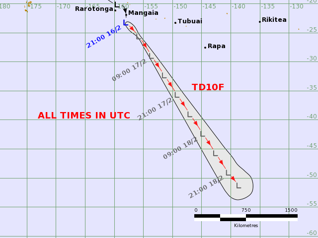
South Pacific Convergence Zone is active over the Cooks and has developed a tropical depression there. This low is expected to travel south and get knocked a little to the west by a HIGH that is moving away to the east along 45S. This track will take the Low closer to NZ by mid-week where it weakens and that may provide a trough line that will affect FREDA's future track.
There is also a TC off Western Australia called MITCHELL. It is travelling south and grazing the coast. It is expected to move a little to the west as it comes south, and weaken.
>>>>>>>>>>>>>>>>>>>>>>>>>>>>>>><<<<<<<<<<<<<<<<<<<<<<<<<<<<<
See my yotpak at http://www.boatbooks.co.nz/weather.html for terms used.
Weathergram with graphics is http://metbob.wordpress.com/2012/11/04/weathergram-4/
Weathergram text only http://weathergram.blogspot.co.nz
Website http://www.metbob.com
Feedback to bob@metbob.com
30 December 2012
23 December 2012
BOBGRAM issued 23 Dec 2012
WEATHERGRAM
YOTREPS
Issued 23 Dec 2012
Bob McDavitt's ideas for sailing around the South Pacific.
Disclaimer: Weather is a mix of pattern and chaos; these ideas are from the patterned world of weather maps, so please fine-tune to your place. Dates are in UTC unless otherwise stated.
The Ocean. Along the Pacific equator, Sea Surface temperatures SST have recently been near normal with some below-normal SST near Galapagos- this situation is considered to support ENSO neutral conditions and computer models are picking this to continue into 2013. There is a zone with SST around 1 or more above normal from Samoa to Tahiti and another off NW Australia—these can possibly encourage the formation of the South Pacific Convergence zone SPCZ during the next few months and bears close watching.
The Atmosphere: Things are changing. The Southern Oscillation Index or SOI (30 day running mean) was hugging the plus 0.5 value since the beginning of September, but during December the 30-day average has dropped to minus 1, and this is in response to lower than normal isobars over Tahiti, so it is a definite shift towards an El Nino-like episode. Interesting.
EVAN is out of the tropics and gradually unwinding like a wind-up Christmas kids toy. It has not been able to encounter a Jetstream or cold front from the southern ocean so is not going to re-intensify like SANDY did. It is going west-wards across northern NZ and is expected to be picked up there by upper NW wins and taken southeastwards across central NZ on Boxing Day. A good blog on the future track of EVAN can be found at http://blog.metservice.com/2012/12/christmas-weather-daily-update/
Next week?
At this stage GFS model is picking that another tropical low may deepen into a cyclone between Solomons and Vanuatu by Friday 28 Dec and then go SSE to cross New Caledonia area on Mon 31 Dec/Tue 01 Jan. EC model is not so certain as to the intensity of this system yet but agrees with the timing. If you intend to sail in this area then keep checking for updates, and maybe delay. The next name on the list for South Pacific Cyclone is FREDA.
Sydney/Hobart Race –The teams are getting ready for a great race – check out http://rolexsydneyhobart.com/ Weather forecast is for a dream start then NE winds then a westerly or SW change on Dec 28th. If the super maxi can get to Hobart before the westerly they may have a chance of beating the race record of one day, 18 hours, 40 minutes and 10 seconds, set by the then 98 foot super maxi, Wild Oats XI, in 2005.
>>>>>>>>>>>>>>>>>>>>>>>>>>>>>>><<<<<<<<<<<<<<<<<<<<<<<<<<<<<<
See my yotpak at http://www.boatbooks.co.nz/weather.html for terms used.
Weathergram with graphics is http://metbob.wordpress.com/2012/11/04/weathergram-4/
Weathergram text only http://weathergram.blogspot.co.nz
Website http://www.metbob.com
Feedback to bob@metbob.com
16 December 2012
BOBGRAM issued 16 Dec 2012
WEATHERGRAM
YOTREPS
Issued 16 Dec 2012
Bob McDavitt's ideas for sailing around the South Pacific.
Disclaimer: Weather is a mix of pattern and chaos; these ideas are from the patterned world of weather maps, so please fine-tune to your place. Dates are in UTC unless otherwise stated.
The Ocean Along the Pacific equator Sea Surface temperatures SST have recently been near normal with some below-normal SST near Galapagos- this situation is considered to support ENSO neutral conditions and computer models are picking this to continue into the new year. There is a zone with SST more than 1 above normal from Samoa to Tahiti—This can possibly encourage the formation of the South Pacific Convergence zone SPCZ during the next few months and bears close watching.
The Atmosphere: Things are starting to change. The Southern Oscillation Index or SOI (30 day running mean) has been hugging the plus 0.5 value since the beginning of September, but in recent days the 30-day average has dropped to minus 0.5, and this is in response to lower than normal isobars over Tahiti, so it is a definite shift towards an El Nino-like episode. Computer models are picking a neutral SOI for the cyclone season.
This edition of my weathergram is all about EVAN. TC EVAN started as a depression L that drifted east towards Samoa. It started intensifying faster than the computer models were expecting and dealt Apia a severe blow. Then it did a loop and went west and WSW. At present it is category 4 near the north end of Futuna and curving to the SW towards Yasawa. The latest forecast track map from Fiji Met Service shows past track, expected future track and possible variations (black line) and three rings at 12 hour time steps;
http://www.met.gov.fj/aifs_prods/65660.gif . The Fiji Met track map web page is very busy so if you need the latest track in a hurry try this URL to a gif image – it doesn't have the text of the full site so can only be used as an unofficial substitute. Remember to subtract 13 hours to convert the times shown here to UTC.
Note how small this system is, but it is extremely violent near centre during next 48 hours and then should ease to Cat 2 as it encounters cooler seas.
The low is expected to slowly continue south this week and become extra-topical. It is expected to bring cyclonic easterly winds and swell to northern NZ mainly around Sun /Mon 23/24 Dec.
http//bit.ly/7daywx gives the MetService model. The map for 1pm sun 23 Dec= 23 0000UTC issued this evening shows Low to north of northern NZ with just strong winds left, and these are spread out over a wide area.
Next week?
At this stage GFS model takes it across the North Island on Mon 24 Dec and EC model takes it west and weakens into a trough in the Tasman Sea (see http://bit.ly/ecoz). I think that by Boxing Day the winds may well be OK for Kiwi holiday sailing plans.]
Sydney/Hobart Race -Still too far away to be certain. In the map for next Sunday above you can see a heat trough deepening over the Aussie interior, and the possibility of a High forming over the Aussie Bight. One scenario is that this trough may break loose into the Tasman Sea on Boxing day and the High may then move towards the south of Tasmania—that would make a squash zone of enhanced S/SE winds mid-way between Sydney and Hobart in a word, challenging.
>>>>>>>>>>>>>>>>>>>>>>>>>>>>>>><<<<<<<<<<<<<<<<<<<<<<<<<<<<<<<<<
See my yotpak at http://www.boatbooks.co.nz/weather.html for terms used.
Weathergram with graphics is http://metbob.wordpress.com/2012/11/04/weathergram-4/
Weathergram text only http://weathergram.blogspot.co.nz
Website http://www.metbob.com
Feedback to bob@metbob.com
09 December 2012
BOBGRAM issued 9 Dec
WEATHERGRAM
YOTREPS
Issued 9 Dec 2012
Bob McDavitt's ideas for sailing around the South Pacific.
Disclaimer: Weather is a mix of pattern and chaos; these ideas are from the patterned world of weather maps, so please fine-tune to your place. Dates are in UTC unless otherwise stated.
The Atmosphere: The Southern Oscillation Index or SOI (30 day running mean) had a value of MINUS 1.01 back on 25 Aug. It has been gradually rising ever since and on 02 Dec was plus 0.4, and by 9 Dec it has relaxed to plus 0.25. Computer models are picking a neutral SOI for the cyclone season.
Tropical cyclones: Last week TC BOPHA left behind a death toll of over 500 in the Philippines. It has changed course and is heading to Philippines again as a tropical storm.
South Pacific Convergence Zone SPCZ
If you are in the tropics then this is a week when the best thing to do is to stay put.
The South Pacific Convergence Zone SPCZ is dividing into three different zones of activity—one over northern Coral Sea, one between Fiji and Samoa and a third over the Southern cooks. There is now a zone of light north to NW winds on the northern side of the SPCZ, to North of 5S. So the SPCZ is turning into a trough of falling pressure.
The zone over Southern Cooks is expected to develop into a tropical Low on Monday or Tuesday that should travel westwards. There is already some cyclonic curvature showing in the cloud imagery.
The zone between Samoa and Fiji is expected to develop into a Low next-by around Wednesday or Thursday and may well deepen quickly into a tropical Cyclone that may be slow-moving over Fiji during the 15-16 Dec weekend. Avoid.
SUBTROPICAL RIDGE STR
The High over Northern Tasman Sea/North Island tonight is expected to weaken over the next few days. A new High is moving east across Tasmania on Monday, tugging the STR southwards as is expected during summer. This new high is expected to slide across central NZ on Thursday and then out to the east of the North Island next week. Its departure is likely to be a factor in the track of the tropical low over Fiji to the south.
NZ/Tasman Sea
Last Thursday's trough had a wedge of cooler air pushing into the warm pool on its eastern In the western flank of the warm pool there were some NW winds – these had started as part of that heat wave over Australia in the previous week. As these NW winds encountered the west coast of Auckland the friction difference between land and sea causes a convergence zone along the west coast line. As the extra upward motion of the wedge reached this convergence zone, it was able to fire a line of thunderstorms and one of these was severe enough to trigger a tornado. A rare event for west Auckland and this one led to three fatalities, put 7 in hospital and damaged around 200 houses.
This week's troughs are not expected to bring much--- one should fade over the South island on Monday and the next should linger over southern NZ from Friday 14 to Sunday 16 Dec.
There is likely to be a build-up of heat showers over the inland North Island on Wednesday and Thursday 12/13 Dec.
>>>>>>>>>>>>>>>>>>>>>>>>>>>>>>><<<<<<<<<<<<<<<<<<<<<<<<<<<<<<
See my yotpak at http://www.boatbooks.co.nz/weather.html for terms used.
Weathergram with graphics is http://metbob.wordpress.com/2012/11/04/weathergram-4/
Weathergram text only http://weathergram.blogspot.co.nz
Website http://www.metbob.com
Feedback to bob@metbob.com
02 December 2012
BOBGRAM issued 2 Dec 2012
WEATHERGRAM
YOTREPS
Issued 2 Dec 2012
Bob McDavitt's ideas for sailing around the South Pacific.
Disclaimer: Weather is a mix of pattern and chaos; these ideas are from the patterned world of weather maps, so please fine-tune to your place. Dates are in UTC unless otherwise stated.
The Atmosphere: The Southern Oscillation Index or SOI (30 day running mean) had a value of MINUS 1.01 back on 25 Aug. It has been gradually rising ever since and on 02 Dec was plus 0.4. Computer models are picking a neutral SOI for the cyclone season.
Tropical cyclones: Last week TC BOLDWIN was in the Indian Ocean. This week TC BOPHA is in the NW Pacific heading for the Philippines.
South Pacific Convergence Zone SPCZ
The South Pacific Convergence Zone SPCZ has stayed much the same in the past week between Solomons, Vanuatu and Fiji with a side branch from Tuvalu to Tokelau to Northern cooks. At this stage not such change is expected in the SPCZ during the coming week.
SUBTROPICAL RIDGE STR
The STR has been reasonably strong between 25 and 30S across the South Pacific during the past week and is expected to divide into High cells that may take a more southern route this week.
One cell stretched from 170E to 140W along 25 to 30S tonight and is expected to fade away by Tuesday, leaving behind a high near 35S to east of NZ. This high is expected to move east and intensify to a central pressure near 1020 near 150W by Saturday 8 Dec, with a squash zone of intensified trade winds over Southern Cooks.
Next high is expected to move off new South Wales into the central Tasman Sea on Thu/Fri/Sat 6/7/8 and then across central NZ on Sun/Mon to be mainly east of the South island at 40S by Tuesday 11 Dec. The following High may cross Tasmania on Tue/Wed 11/12 Dec—continuing this southern trend for the foreseeable future.
Between the migratory Highs there is room for a few troughs.
One is expected to move off the east of the North Island on Monday. Another is expected to deepen into a low as it crosses southern NZ on Tuesday and Wednesday. Without reprieve another Low is expected to deepen as it crosses NZ on Thursday and Friday- deepening to 980hPa as a large Low south of Chathams Islands. This Low is expected to support strong to gale SW winds and heavy SW swells in the Tasman Sea on Wednesday/Thursday. Avoid.
>>>>>>>>>>>>>>>>>>>>>>>>>>>>>>><<<<<<<<<<<<<<<<<<<<<<<<<<<<<<
See my yotpak at http://www.boatbooks.co.nz/weather.html for terms used.
Weathergram with graphics is http://metbob.wordpress.com/2012/11/04/weathergram-4/
Weathergram text only http://weathergram.blogspot.co.nz
Website http://www.metbob.com
Feedback to bob@metbob.com
Subscribe to:
Posts (Atom)