Followers

Translator

Bob McDavitt's ideas for sailing weather around the South pacific

27 August 2017

Bob Blog 27 Aug 2017

WEATHERGRAM

YOTREPS

Compiled Sun 27 Aug 2017


Bob McDavitt’s ideas for sailing around the South Pacific.

Disclaimer: Weather is a mix of pattern and chaos; these ideas are from the patterned world.


LISA BLAIR arrived back in Sydney yesterday—the first woman to circumnavigate Antarctica solo in a yacht.

For a VIDEO OF S/v CLIMATE ACTION NOW closing in on Sydney heads see tinyurl.com/y8zytx6h

I have been helping Lisa with some weather information during this fantastic adventure.


TROPICS

Both HARVEY (Texas) and PAKHAR (Hong Kong) have moved inland and turned into wet tropical depressions.

There are two tropical depressions at present, one is east of PAKHAR and is forecast to go north and stay east of Japan. T’other is in the Atlantic and is forecast to go N/NE and may sideswipe the Eastern seaboard of United States with some northerly winds on its western side.

We can see these track possibilities at ruc.noaa.gov/


Last week’s rain map, compared with the week before, shows the most intense rain is still around Southeast Asia in the monsoon. This is affecting 41 million people, and there have been 1200 recent deaths, see www.aljazeera.com/news/2017/08/floods-kill-1200-india-nepal-bangladesh-170826230610924.html.


In the tropical South Pacific, the rain map at trmm.gsfc.nasa.gov/trmm_rain/Events/big_global_accumlation.gif shows a general decrease in activity.


WEATHER ZONES

SPCZ=South Pacific Convergence zone.

The SPCZ is expected to stay put his week and linger across east Solomon Islands and Tuvalu slowly spread southwards towards Fiji and Samoa this week.

A trough is travelling east off NZ tonight and is expected to travel east and is expected to affect the region between NZ and south of Tonga during the next few days.

Another trough is expected to travel east across the Society Islands and Tahiti from mid-to-late week, but since this region is at the northern end of this trough, its impact is minor.


Subtropical ridge (STR)

HIGH 1033hPa east of NZ is expected to travel east along 40S and build to 1036hPa during Monday/Tuesday/Wednesday and then slowly ease and travel off to the southeast. Although this is 25degrees of latitude away from the tropics, this HIGH is expected to squeeze the isobars near 15S closer together forming a squash zone of strong trade winds and swells rising to 3 to 4 metres mid-week between Borabora and Samoa. Avoid.

One of my quotes applies "When the HIGH is over 1030 it's going to get dirty"


French Polynesia, going to the west:

Not this week. We should wait a while until after this squash zone.


Between NZ and the tropics:

A Low is expected to travel east across North island on Wednesday UTC and another on Friday UTC.

If in NZ, may as well stay put this week.

If travelling to NZ, arrange arrival after Sat 2 Sep.


Between Australia and the tropics:

Weak subtropical ridge is expected to linger over northern Tasman Sea between Queensland and south of New Caledonia. Southwest winds are likely south of 30S.


If you would like more detail for your voyage, then check metbob.com to see what I offer.

>>>>>>>>>>>>>>>>>>>>>>>>>>>>>>>>>>>>>>>>>>>>>>>>>>>>>>>> 

See my website http://www.metbob.com for more information

Feedback to bob@metbob.com or txt 6427 7762212

Weathergram text only (and translator) is at weathergram.blogspot.co.nz.

Weathergram with graphics is at metbob.wordpress.com,

Click FOLLOW at bottom right to subscribe.

To unsubscribe send a reply email saying LEAVE.

>>>>>>>>>>>>>>>>>>>>>>>>>>>>>>>>>>>>>>>>>>>>>>>>>>

20 August 2017

Bob Blog 20 Aug 2017

WEATHERGRAM
YOTREPS
Compiled Sun 20 Aug 2017

Bob McDavitt's ideas for sailing around the South Pacific.
Disclaimer: Weather is a mix of pattern and chaos; these ideas are from the patterned world.

The state of the ENSO
The Atmosphere:
El Nino and La Nina the opposite ends of an identifiable tropical influence on our seasonal weather: the La Nina shifts the subtropical ridge away from the equator and the El Nino draws the subtropical ridge closer to the equator. Their comings and goings can last several months, maybe over a year, and so their status can be used to forecast the weather for the coming season.
The main data from the atmosphere is the Southern Oscillation Index SOI (30 day running mean) as it sums up the weather pattern over the South Pacific as one number. It is based on the standardized difference in the barometer readings between Tahiti and Darwin, in other words the placement of isobars on the weather map. When the SOI is more than plus one (standard deviation from its mean) for more than a month we call it a LA NINA event, and when it stays more than minus one we call it an EL NINO event.
So far this year there have been an unsteady swings either way, and at present we are on the La Nina side of zero, but that has peaked so I think we are still in some more unsteady swings over the next few months, with the SOI basically hovering around zero. This means the subtropical ridge may wander a little north or south of its seasonal normal position, but not hover away from its norm long enough for us to change our cruising plans. Just keep an eye on that subtropical ridge.

An unsteady SOI is seen at www.farmonlineweather.com.au/climate/indicator_enso.jsp?c=soi&p=weekly (Note that in this graph on the vertical axis 10= 1 standard deviation)

The Ocean:
NINO3.4 is a region in the eastern equatorial Pacific Ocean that acts as a heat storage area during an El Nino, or becomes cooler than normal during a La Nina. This plays with the heat budget of the atmosphere and thus with the weather patterns.
At the farmonline web site we can see the trend in the sea surface temperature in the NINO3.4 area. The diagram shows the weekly temperature anomalies since Jan 2014, with the El Nino of 2015 looking like a hump on a camel. Since then there has been a cool period late 2016/early2017, and then a warm period until July 2017. We are now in a near zero or neutral state. .

Neutral territory as seen at ww.farmonlineweather.com.au/climate/indicator_enso.jsp?c=nino34&p=monthly

The International Research Institute of the Climate Prediction Centre compile data from several ENSO prediction models. The overall trend is towards little change later this year, with most all of the models within -0.5 and +0.5.

For CPC/IRI predictions see iri.columbia.edu/our-expertise/climate/forecasts/#ENSO_Forecasts

One seasonal prediction that can be made is that the number of tropical cyclones forming in the North Pacific Ocean over the next few months. This is likely to be more than normal, due to warmer than normal seas. It is too early at this stage to comment on the incoming South Pacific cyclone season starting later this year..... but the early indication is that, because of warmer than normal seas, there may be an increased risk.

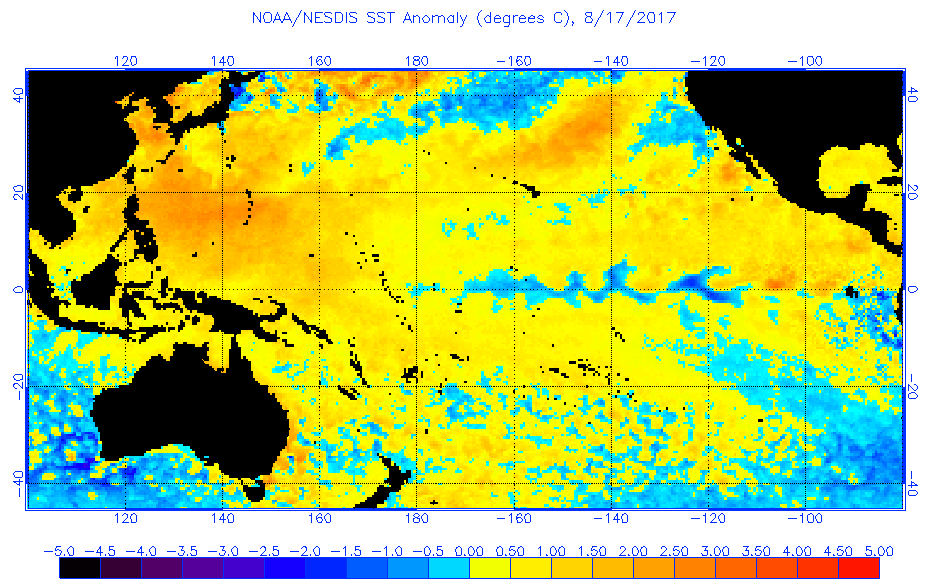
For Sea surface temperatures across the Pacific on 17 Aug see www.ospo.noaa.gov/data/sst/anomaly/2017/anomp.8.17.2017.gif

TROPICS
At present tropical cyclone HARVEY is travelling west onto central america and KENNETH tavelling northwest off the west Mexican coas. There is a depression heading west into the China Sea and another on the Atlantic west of Africa that may travel west to Florida. We can see these tracks at ruc.noaa.gov/

Last week's rain map, compared with the week before, shows a shift of intense rain from Myanmar to Indonesia, and an easing of rain in the NW Pacific. In the tropical South Pacific, the rain map shows a passing intense trough during the past week; as mentioned in last week's weathergram. And there are continuing hotspots of intensity around Panama and Sierra Leone.
A link to the devastating mudslides in Sierra Leone is at
www.independent.co.uk/news/world/africa/sierra-leone-mudslides-latest-fears-1000-people-dead-bodies-a7902806.html

Rain for the past week is at trmm.gsfc.nasa.gov/trmm_rain/Events/big_global_accumlation.gif

WEATHER ZONES
SPCZ=South Pacific Convergence zone.
The SPCZ is expected to slowly spread southwards towards Fiji and Samoa this week.
Also a passing trough is expected to bring some rain to the Tonga and Niue area early this week and then fade away. Accumulated rainfall may be seen at from windyty.com

Generically speaking, a passing trough in the South Pacific islands is preceded by a period of weakening northerly winds, accompanied by variable winds and showers and then followed by a period of S then SE winds. Satellite imagery shows that these troughs travel eastwards, and that may appear confusing at first to someone on the ground considering these wind changes. However, if we look at a time/height diagram of the wind flow over, say, Nuku'alofa, we can see there are lots more westerly winds aloft than easterly winds at the surface, and THAT is what explains the eastward travel of these passing troughs.


For Time/height diagram over Nuku'alofa, see windyty.com, type in nukualofa as the search box then select airgram. (This diagram has the wind barbs on wrong side of arrow shaft, treating them as northern hemisphere winds).

Subtropical ridge (STR)
High is expected to build in the North Tasman sea on Monday and then travel onto northern NZ by Wednesday and then travel slowly to east of the North Island by the end of the week building to around 1029hpa. This should help maintain SE trade winds between French Polynesia and Tonga.

Between NZ and the tropics:
Low near Chatham Islands tonight is travelling off to the east. The southerly flow and swell on the backside of this low should weaken over northern NZ on Monday and Tuesday, then the outlook over northern NZ is for light winds on Wednesday to Friday, then we expect strengthening NE winds ahead of an approaching trough on Sat and Sunday.
So, the best days for getting off to the north are Monday and Tuesday, and a departure on Wednesday may be OK as well.

Between Australia and the tropics:
A trough is expected to travel off the eastern seaboard and into Tasman sea on Tuesday and then travel east across the Tasman Sea and deepen into a low on Wednesday that should reach the South Island early next week, with associated trough reaching New Caledonia around Sunday and North Island around Monday 28 August.
Any travel form Australia to tropics should be on back side of that trough, and any travel from New Caledonia to Australia this week will need to encounter this trough.

French Polynesia to the West:
There is a passing rough over tonga tonight that is travelling east and expected to fade south of Niue during Monday UTC.
After that a slow-moving and not-very-intense High /subtropical ridge along 30 to 35S should ensure moderate trade winds and swells, good for sailing westwards.
If you would like more detail for your voyage, then check metbob.com to see what I offer.

>>>>>>>>>>>>>>>>>>>>>>>>>>>>>>>>>>>>>>>>>>>>>>>>>>>>>>>>
See my website http://www.metbob.com for more information
Feedback to bob@metbob.com or txt 6427 7762212
Weathergram text only (and translator) is at weathergram.blogspot.co.nz.
Weathergram with graphics is at metbob.wordpress.com,
Click FOLLOW at bottom right to subscribe.
To unsubscribe, send a reply email saying LEAVE.
>>>>>>>>>>>>>>>>>>>>>>>>>>>>>>>>>>>>>>>>>>>>>>>>>>

13 August 2017

Bob Blog 13 Aug 2017

WEATHERGRAM
YOTREPS
Compiled Sun 13 Aug 2017

Bob McDavitt's ideas for sailing around the South Pacific.
Disclaimer: Weather is a mix of pattern and chaos; these ideas are from the patterned world.

TROPICS
At present tropical cyclone JOVA is travelling ESE (a strange direction) off the west Mexican coast and a tropical depression is expected to take a clockwise path around the Atlantic Ocean.
Meanwhile TC BANYAN is in the Northwest Pacific and is expected to go north and then northeast - its remains may reach Alaska, perhaps.
We can see these tracks at ruc.noaa.gov/tracks/

Last week's rain map, compared with the week before, shows continuing high rainfall around the NW Pacific, and the equatorial Indian Ocean, and the equatorial Atlantic Ocean. It has been very wet around Bangladesh, and there is a build-up of activity along the South Pacific Convergence zone.

Rain for the past week is from trmm.gsfc.nasa.gov/trmm_rain/Events/big_global_accumlation.gif

WEATHER ZONES
SPCZ=South Pacific Convergence zone.
The SPCZ is expected to shrink and shift to the north this week. The build-up of shower activity that occurred last week is expected to be gathered by a tropical trough and conducted south-southeastwards across Tonga /Niue area on Wednesday 16 Aug UTC.

Subtropical ridge (STR)
High to northeast of NZ is expected to travel east along 30 to 35s this week and build to a peak of over 1035 on Thursday 17 Aug UTC. This is expected to produce a squash zone of enhanced trade winds on the north side of this High on 17 to 19 Aug UTC-this should mainly affect French Polynesia.
New High is expected to move off eastern Australia into North Tasman Sea on Monday, and to travel along 20 to 30S past northern NZ on wed/thu UTC. This high is taking the typical path of a winter anticyclone.


Between Australia /NZ and the tropics:
Light winds in the subtropics between 20 and 30s with the incoming high.
South of 30s the pattern is a typical winter of disturbed westerlies, made stronger and squally by a deep Southern Ocean low travelling east along 45 to 55S, 960hpa, in Aussie Bight by Tuesday and south of the Taman Sea by Friday. SW swells up to 5+ metres with a period over 10 seconds in Tasman sea by this weekend.

French Polynesia to the west:
The trough that is expected to travel south-southeast over the Tonga/Niue area on Wed 16 Aug is likely to dominate the landscape this week for any vessels hoping to travel westwards towards Tonga.
It is likely to be an active trough because it is taking away (southwards) the build-up of extra energy from the SPCZ. Also, as this extra warmth comes south it is likely to encounter the colder denser airmass which crossed North Island tonight showing itself as an upper trough with lots of thunder and lightning.
I'll assume that it may be better to wait for this trough to make its way south-southeast, and so delay that trip toward Tonga until later this week or early next week.
The trough should bring a brief period of strong NE winds to Niue on Wednesday morning local or Rarotonga around Friday morning local.
If you would like more detail for your voyage, then check metbob.com to see what I offer.
>>>>>>>>>>>>>>>>>>>>>>>>>>>>>>>>>>>>>>>>>>>>>>>>>>>>>>>>
See my website http://www.metbob.com for more information
Feedback to bob@metbob.com or txt 6427 7762212
Weathergram text only (and translator) is at weathergram.blogspot.co.nz.
Weathergram with graphics is at metbob.wordpress.com,
Click FOLLOW at bottom right to subscribe.
To unsubscribe send a reply email saying LEAVE.
>>>>>>>>>>>>>>>>>>>>>>>>>>>>>>>>>>>>>>>>>>>>>>>>>>

06 August 2017

Bob Blog 6 Aug 2017

WEATHERGRAM
YOTREPS
Compiled Sun 6 Aug 2017

Bob McDavitt's ideas for sailing around the South Pacific.
Disclaimer: Weather is a mix of pattern and chaos; these ideas are from the patterned world.

TROPICS
NORU is still going and is expected to visit Japan this week, and NALGAR is over the open ocean further east. There are two tropical depressions on the Atlantic Ocean that may develop further during the coming week. We can see these at ruc.noaa.gov/tracks/

Last week's rain map, compared with the week before, shows continuing high rainfall around Japan, the equatorial Indian Ocean, and possibly the equatorial Atlantic ocean, and decreasing amounts elsewhere.

Rain for the past fortnight from trmm.gsfc.nasa.gov/trmm_rain/Events/big_global_accumlation.gif

WEATHER ZONES
SPCZ=South Pacific Convergence zone.
The SPCZ starts this week draped from Solomon Islands to Tuvalu and Tokelau Islands to Northern Cooks. An MJO event is moving into the western Pacific this week and that should help activate the SPCZ.
A convergence zone /trough is expected to travel east across the Society Islands on local Monday. Better to stay put for that and depart local Tuesday.
Next trough from the west is expected to reach New Caledonia on local Wednesday and Tonga area on local Friday, it's a minor trough but worthy of consideration.

Subtropical ridge (STR)
High east of NZ is expected to travel east along 30s until Thursday and then weaken as a High from further south builds around 160W.
New High is expected to move off eastern Australia into North Tasman Sea on Thursday, and travel along 28S past norther NZ by Saturday 12 Aug.

Between Australia /NZ and the tropics:
Low is expected to travel east along 40S from Monday to Wednesday across Southern Tasman sea. Moving southeast across central NZ on Thursday.

French Polynesia to the west:
A trough/convergence zone that is expected to be crossing the Society Islands on local Monday UTC. Wait until TUESDAY and its should be ok to go west from Society islands.
The SPCZ is expected to be mainly confined to the Solomon Islands to Tokelau Islands area, but may extend to Suwarrow by end of the week.

If you would like more detail for your voyage, then check metbob.com to see what I offer.
>>>>>>>>>>>>>>>>>>>>>>>>>>>>>>>>>>>>>>>>>>>>>>>>>>>>>>>>
See my website http://www.metbob.com for more information
Feedback to bob@metbob.com or txt 6427 7762212
Weathergram text only (and translator) is at weathergram.blogspot.co.nz.
Weathergram with graphics is at metbob.wordpress.com,
Click FOLLOW at bottom right to subscribe.
To unsubscribe send a reply email saying LEAVE.
>>>>>>>>>>>>>>>>>>>>>>>>>>>>>>>>>>>>>>>>>>>>>>>>>>

Blog Archive