WEATHERGRAM
YOTREPS
Compiled Sun 30 July 2017
Bob McDavitt's ideas for sailing around the South Pacific.
Disclaimer: Weather is a mix of pattern and chaos; these ideas are from the patterned world.
The state of the ENSO
The Atmosphere:
You may have heard about El Nino and its opposite, La Nina. They are tropical influences on the weather: the La Nina shifts the subtropical ridge away from the equator and the El Nino draws the subtropical ridge closer to the equator. Their comings and goings can last several months, maybe over a year, and so their status can be used to forecast the weather for the coming season.
A month or so ago we were on the brink of a possible El Nino, but latest data shows things are "unsteady".
The main data from the atmosphere is the Southern Oscillation Index SOI (30 day running mean) as it sums up the weather pattern over the South Pacific as one number. It is based on the standardized difference in the barometer readings between Tahiti and Darwin, in other words the placement of the isobars on the weather map. When the SOI is more than plus one (standard deviation from its mean) for more than a month we call it a LA NINA event, and when it stays more than minus one we call it an EL NINO event.
For most of the period from May 2015 to May 2016 we had an extreme El Nino. Then there was a weak La Nina in October 2016, and since then we have had several fluctuations, plus then minus, each lasting around a month. For want of a better word, I'll describe this as "UNSTEADY". The latest SOI, last week, is plus .5 (or plus 5 in the units used in the farmonline site), and shows a continuing of this "unsteady" trend.
An unsteady SOI is seen at www.farmonlineweather.com.au/climate/indicator_enso.jsp?c=soi&p=weekly
The Ocean:
NINO3.4 is a region in the eastern equatorial Pacific Ocean that acts as a heat storage area during an El Nino, or becomes cooler than normal during a La Nina. This plays with the heat budget of the atmosphere and thus with the weather patterns.
At the farmonline web site we can see the trend in the sea surface temperature in the NINO3.4 area. The diagram shows the weekly temperature anomalies since Jan 2014, with the El Nino of 2015 looking like a hump on a camel. Since then there has been a cool period late 2016/early2017 , and a warm period so far in 2017. This warmth is getting less over last few weeks. It seems that the trend in towards a neutral state.
Neutral territory is seen at www.farmonlineweather.com.au/climate/indicator_enso.jsp?c=nino34&p=monthly
The International Research Institute of the Climate Prediction Centre compile data from several ENSO prediction models. The overall trend is towards little change later this year, with most of the models on the side of a weak El Nino.
CPC/IRI predictions are at
iri.columbia.edu/our-expertise/climate/forecasts/#ENSO_Forecasts
One seasonal prediction that can be made is that the number of tropical cyclones forming in the North Pacific Ocean over the next few months is likely to be more than normal, due to warmers than normal seas. It is too early at this stage to comment on the incoming South Pacific cyclone season starting later this year.
EVIDENCE OF CLIMATE CHANGE:
People have been noting warmer summer temperatures in the Northern Hemisphere, and Dr. Hanen and two colleagues have been extracting some bell curves for various decades to compare with the 1951-1980 epoch. See www.pnas.org/content/109/37/E2415.full or /www.nytimes.com/interactive/2017/07/28/climate/more-frequent-extreme-summer-heat.html?mcubz=1
-- the New York Times doesn't explain much about the methods used, but the PNAS paper gives a full account.
TROPICS
This is the peak of the heat for the Northern summer, and, sure enough , it's busy with cyclones as we can see from ruc.noaa.gov/tracks/, showing 5 cyclones = HILARY and IRWIN east of Hawaii, and NORU, HAITANG, and NESAT between Hawaii and China. Also an "invest" area. These storms are mostly oceanic, but for NESAT heading for Taiwan with HAITANG on its heels.
Last week's rain map, from trmm.gsfc.nasa.gov/trmm_rain/Events/big_global_accumlation.gif, compared with the week before, shows continuing high rainfall over parts of India and across SE Asia to the Philippines and an increase in rain around Solomon Islands. The path of cyclone NORU stands out.
WEATHER ZONES
SPCZ=South Pacific Convergence zone.
The SPCZ starts this week draped from Solomon Islands to Tuvalu and Tokelau Islands, and slowly increasing in intensity.
A convergence zone /trough tonight stretches from Vanuatu to Fiji to Tonga containing variable winds and a few squalls. This is expected to travel southeast and deepen into a low near 30S on Tuesday UTC, that may then bomb (rapid deepening) to 972 hPa at 40S 40E by Thursday. Too far away to bother anyone, but may generate southerly swells to over 4 metres for the Gambier Islands by the weekend. Long period swells that are loved by surfers. Accompanying convergence zone is expected to pass to east of Rarotonga on Tue UTC and then stall and then return to south across Rarotonga on Sat 5 Aug UTC.
Subtropical ridge (STR)
High over NZ tonight is expected to travel northeast to 30S then eastwards at around 1020 hPa- not strong enough to enhance the southeast trade winds on its northern side.
Next High is expected to form over south Tasman sea on Tuesday and travel around the south end of NZ and then along 50S to 170W by the weekend.
Between Australia /NZ and the tropics:
Low is expected to deepen in Tasman Sea off New South Wales on Monday and then travel east across Northland on local Thursday and then travel east along 33S to east of NZ to the end of the week. It may be followed by another low deepening off the New South Wales coast on local Thursday. Avoid these lows/.
French Polynesia to the west:
The main challenge for going west this week is the trough/convergence zone that is expected to be crossing the Tongan area on Monday UTC. This zone is expected to continue southeast past Rarotonga on Tue/wed UTC and then stall and travel back southwards across Rarotonga around Sat UTC. Avoid.
This zone is not expected to have much impact any further north-a trip via Palmerston Island is likely to be mostly unaffected.
The SPCZ is expected to be confined to the Solomon Islands to Tokelau Islands area.
If you would like more detail for your voyage, then check metbob.com to see what I offer.
>>>>>>>>>>>>>>>>>>>>>>>>>>>>>>>>>>>>>>>>>>>>>>>>>>>>>>>>
See my website http://www.metbob.com for more information
Feedback to bob@metbob.com or txt 6427 7762212
Weathergram text only (and translator) is at weathergram.blogspot.co.nz.
Weathergram with graphics is at metbob.wordpress.com,
Click FOLLOW at bottom right to subscribe.
To unsubscribe, send a reply email saying LEAVE.
>>>>>>>>>>>>>>>>>>>>>>>>>>>>>>>>>>>>>>>>>>>>>>>>>>
30 July 2017
23 July 2017
Bon blog for 23 July
WEATHERGRAM
YOTREPS
Compiled Sun 23 July 2017
Bob McDavitt's ideas for sailing around the South Pacific.
Disclaimer: Weather is a mix of pattern and chaos; these ideas are from the patterned world.
CONGRATULATIONS
Bravo to Lisa Blair for being the first woman to sail solo around Antarctica below 45 South (with one stop due to a dismasting). Lisa crossed her outgoing track on Friday 21 July at 9:48pm local time. Inspirational.
I have been emailing daily weather ideas to Lisa throughout this trip, but that's just idea- sharing and does not affect her claim to have sailed this adventure solo and unassisted (but for the stop at Cape Town for a new mast). Lisa has had knock downs, giant waves, winds over 80 knots, snow, hail, bumped into a container ship, encountered an easterly gale, and wallowed in large wind holes. Her blogs are at lisablairsailstheworld.com/blog/
If you feel inspired by this accomplishment, please buy one of her beanies to help out, while they are still available. See lisablairsailstheworld.com/shop
TROPICS
This is the peak of the heat for the Northern summer, sometimes called 'the Dog Days' - named for the appearance just before dawn of Sirius, the Dog star and brightest star in the sky, from around 19 July. Sure enough, it's busy with cyclones as we can see from ruc.noaa.gov/tracks/, showing 5 cyclones = Fernanda and Greg east of Hawaii, and Kolup, Noru and Roke between Hawaii and China.
Also 3 depressions and 3 "invest" areas. These storms are mostly oceanic, but Roke seems to be heading for Hong Kong, and the remains of a faded Fernanda may bring some rain to a dry Hawai'i, if they are lucky.
Last week's rain map, compared with the week before, shows a decrease in rain around the South Pacific, and an enhancement in the rain over India, SE Asia and Indonesia.
Rain for the past week may be seen at trmm.gsfc.nasa.gov/trmm_rain/Events/big_global_accumlation.gif
WEATHER ZONES
SPCZ=South Pacific Convergence zone.
The SPCZ starts this week draped from Solomon Islands to Tuvalu and Tokelau Islands, and is having a weak week further east.
A passing trough, associated with a front in the Southern Ocean, is expected to go east across southern cooks on local Tuesday, and another may reach New Caledonia area on local Thursday and then move onto the Tongan area by local Sunday. These troughs are preceded by NE winds and followed by south or southeast winds.
Subtropical ridge (STR)
From Monday to Wednesday UTC a HIGH is expected to travel east across northern Tasman sea along 27S, and the further east to east of NZ along 30s from Thursday to Sunday UTC. There may be a squash zone of enhanced SE trade winds near 10 to 15S on the north side of this High.
From Friday to Monday UTC, another High is expected to travel east across northern Tasman sea along 30S.
Between NZ and the tropics:
Avoid the trough that is expected to be crossing northern NZ on Wed/Thu and early Friday.
French Polynesia to the west:
This looks to be a good week to go west. The SPCZ is still weak and expected to be confined to the Solomon Islands to Tokelau Islands area. However, there may be a squash zone of enhanced trade winds between Tahiti and Niue between Friday and Sunday local.
Also, a weak passing trough is expected to affect southern cooks on local Tuesday, and another may affect New Caledonia on local Thursday.
If you would like more detail for your voyage, then check metbob.com to see what I offer.
>>>>>>>>>>>>>>>>>>>>>>>>>>>>>>>>>>>>>>>>>>>>>>>>>>>>>>>>
See my website http://www.metbob.com for more information
Feedback to bob@metbob.com or txt 6427 7762212
Weathergram text only (and translator) is at weathergram.blogspot.co.nz.
Weathergram with graphics is at metbob.wordpress.com,
Click FOLLOW at bottom right to subscribe.
To unsubscribe send a reply email saying LEAVE.
>>>>>>>>>>>>>>>>>>>>>>>>>>>>>>>>>>>>>>>>>>>>>>>>>>
16 July 2017
Bob blog 16 July 2017
WEATHERGRAM
YOTREPS
Compiled Sun 16 July 2017
Bob McDavitt's ideas for sailing around the South Pacific.
Disclaimer: Weather is a mix of pattern and chaos; these ideas are from the patterned world.
TROPICS
Tonight HURRICANE FERNANDA is travelling west-northwards away from the Mexican west coast. And it is being followed by a tropical depression.
It is vaguely heading towards Hawaii, but at its current pace will not reach those longitudes until 24 July and is likely to fade away by then.
And there is TALAS in the China Sea. The models are picking it may travel west across SE Asia , but will probably fade away inland. Cyclone tracks may be seen at https://ruc.noaa.gov/tracks/
Last week's rain map, compared with the week before, from trmm.gsfc.nasa.gov/trmm_rain/Events/big_global_accumlation.gif, shows an enhancement in the rain in Solomon islands, and relaxing rain along the ITCZ.
WEATHER ZONES
SPCZ=South Pacific Convergence zone.
The SPCZ starts this week reasonably active around Solomon Islands, and is expected to slowly weaken during the week.
A passing trough, associated with a front in the Southern Ocean, is expected to go east across New Caledonia area on local Thursday and then move onto the Tongan area on local Saturday preceded by NE winds and followed by southerlies.
Subtropical ridge (STR)
HIGH located over Northern NZ tonight is expected to travel east along 33s to east of NZ this week. It may build to over 1040 when it gets east of 140W after Friday and the should have a squash zone strong SE winds and over 3m swell on its northern side, around the Gambier Islands.
Australia to New Caledonia:
A trough is expected is to travel east across the eastern seaboard on Tuesday night local, followed by strong SW winds and large swells on Wednesday. It should be ok to depart on Thursday but the voyage will need to go ese at first and allow for ESE wind after 158E.
Departing northern NZ to the north or east for the tropics:
North to NW winds over northern NZ until a cold front crosses the area on Wednesday/Thursday. It may be ok for departure on Friday if you don't mind SW winds and 3 metres swells. Otherwise better to wait until Saturday.
French Polynesia to the west:
This looks to be a good week to go west. The SPCZ is weak and the subtropical ridge is not expected to produce much of a squash zone on this path - however you may get swell over 3 metres on Thursday UTC.
If you would like more detail for your voyage, then check metbob.com to see what I offer.
>>>>>>>>>>>>>>>>>>>>>>>>>>>>>>>>>>>>>>>>>>>>>>>>>>>>>>>>
See my website http://www.metbob.com for more information
Feedback to bob@metbob.com or txt 6427 7762212
Weathergram text only (and translator) is at weathergram.blogspot.co.nz.
Weathergram with graphics is at metbob.wordpress.com,
Click FOLLOW at bottom right to subscribe.
To unsubscribe send a reply email saying LEAVE.
>>>>>>>>>>>>>>>>>>>>>>>>>>>>>>>>>>>>>>>>>>>>>>>>>>
09 July 2017
Bob blog 9 July
WEATHERGRAM
YOTREPS
Compiled Sun 9 July 2017
Bob McDavitt's ideas for sailing around the South Pacific.
Disclaimer: Weather is a mix of pattern and chaos; these ideas are from the patterned world.
Last month (June)
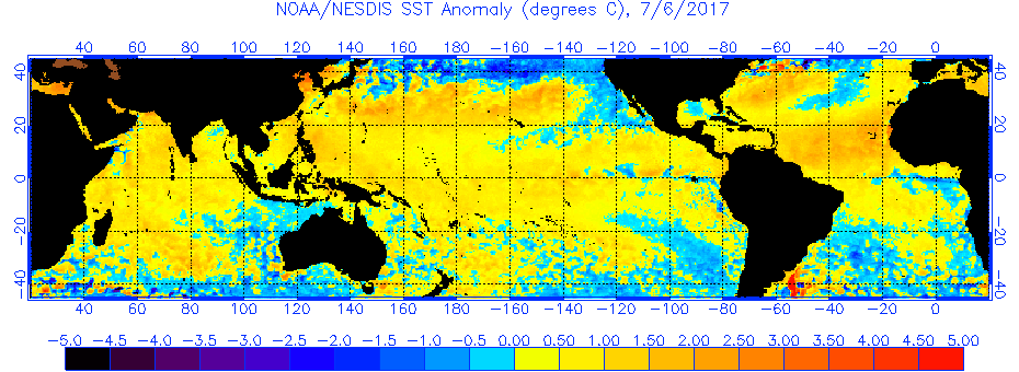
Sea Surface temperature anomalies may be seen at http://www.ospo.noaa.gov/data/sst/anomaly/2017/anomg.7.6.2017.gif
and show that there continues to be more area covered by warm anomalies than by cool anomalies. And there is still a warm river appearing along east coast of South America.
To see how the annual weather cycle and the seasons are working out, take a look at the average isobar maps from www.esrl.noaa.gov/psd/map/images/fnl/slp_30b.fnl.html
In June, the subtropical ridge in the southern hemisphere has travelled NORTHWARDS. This trend is subtle and can be seen in the isobars around NZ. The STR is strong in the Indian Ocean. Looking at the anomalies, the large continuous red area from south Indian Ocean to South Australia/NZ to east of NZ in the South Pacific, shows that the STR has been covering more latitudes than normal, and encouraging blocking highs --- explaining the dry winter in Australia.
The small green anomaly in the North Tasman Sea shows that was a favoured spot for lows to deepen in June, bringing many cyclone NE winds to northern NZ, bringing wet conditions.
The wetter than normal conditions over northern NZ also shows in the monthly rain map. This monthly rain map shows heaviest rainfall in spots from Myanmar across southern China to South Japan, and over Solomons. Last 30 days of rainfall, and its anomaly, are seen at trmm.gsfc.nasa.gov/trmm_rain/Events/thirty_day.html
TROPICS
Deluging rain associated with TC NANMADOL brought damaging landslides to Japan, with a death toll of at least 15 people. See phys.org/news/2017-07-nasa-tropical-cyclone-nanmadol-japan.html
Tonight HURRICANE EUGENE is travelling northwest off and parallel to the Mexico west coast.
Last week's rain map from trmm.gsfc.nasa.gov/trmm_rain/Events/big_global_accumlation.gif
shows an enhancement in the rain in the ITCZ over Eastern Pacific, and relaxing rain in other areas.
WEATHER ZONES
SPCZ=South Pacific Convergence zone.
The SPCZ starts this week reasonably active from Solomon Island to the Tuvalu/Tokelau area, and is expected to weaken during the week.
A passing trough, associated with a front in the Southern Ocean, is expected to go east across Rarotonga area on Tuesday UTC. Another passing trough may reach New Caledonia area around Wednesday UTC and then move onto the Tongan area on Thursday UTC and may bring some NE/N winds to Niue on Friday 14 July UTC and Rarotonga on Sat 15 UTC.
Subtropical ridge (STR)
HIGH is expected to slide southeast off Australia and into the South Tasman Sea on local Wednesday and then southeast past the south of NZ on local Friday. Another HIGH, rather weak, is expected to drift odd east Aussie on Friday local and move onto northern NZ around local Sunday 16 July.
Australia to New Caledonia:
For much of this week, this voyage is between the HIGH over Australia and low pressures over NZ, so it is mainly a disturbed SW/S/SSE flow to New Caledonia, but with wind holes in passing weak ridges.
Late in the week a trough is expected to reach Brisbane area by Sat 15 July local and that should be followed by a weather pattern offering a better sailing breeze for this trip.
Departing northern NZ to the north or east for the tropics:
On Monday, decreasing SW flow over northern NZ, and a brief break in the weather there on Tuesday may allow voyages to escape to Tonga, but not to Fiji or New Caledonia.
On Tuesday, a cold southerly is expected to reach the South Island following a trough. By Wednesday, this trough is expected to deepen into a low over the North Island and linger until it finally travels off to the east on Friday. Although this low is only being fed by southerlies from around 50S, it is cold enough to be a notable winter low with rough seas and swells over 4 sig metres north of NZ on Thursday, so may as well stay put and let it pass.
French Polynesia to the west:
There is a weak passing trough over Society Islands on 10/11 Monday/Tuesday local. This is preceded by a NW flow and followed by SE to E winds. It may be better to wait until after this trough for departure to the west.
This passing trough is likely to reach Palmerston Island by around local Monday, so wait there until local Tuesday for departure.
Another passing trough is expected to reach Niue area on local Thursday 13 July with NE winds. Avoid being there then or moor well.
If you would like more detail for your voyage, then check metbob.com to see what I offer.
>>>>>>>>>>>>>>>>>>>>>>>>>>>>>>>>>>>>>>>>>>>>>>>>>>>>>>>>
See my website http://www.metbob.com for more information
Feedback to bob@metbob.com or txt 6427 7762212
Weathergram text only (and translator) is at weathergram.blogspot.co.nz.
Weathergram with graphics is at metbob.wordpress.com,
Click FOLLOW at bottom right to subscribe.
To unsubscribe send a reply email saying LEAVE.
>>>>>>>>>>>>>>>>>>>>>>>>>>>>>>>>>>>>>>>>>>>>>>>>>>
YOTREPS
Compiled Sun 9 July 2017
Bob McDavitt's ideas for sailing around the South Pacific.
Disclaimer: Weather is a mix of pattern and chaos; these ideas are from the patterned world.
Last month (June)
Sea Surface temperature anomalies may be seen at http://www.ospo.noaa.gov/data/sst/anomaly/2017/anomg.7.6.2017.gif
and show that there continues to be more area covered by warm anomalies than by cool anomalies. And there is still a warm river appearing along east coast of South America.
To see how the annual weather cycle and the seasons are working out, take a look at the average isobar maps from www.esrl.noaa.gov/psd/map/images/fnl/slp_30b.fnl.html
In June, the subtropical ridge in the southern hemisphere has travelled NORTHWARDS. This trend is subtle and can be seen in the isobars around NZ. The STR is strong in the Indian Ocean. Looking at the anomalies, the large continuous red area from south Indian Ocean to South Australia/NZ to east of NZ in the South Pacific, shows that the STR has been covering more latitudes than normal, and encouraging blocking highs --- explaining the dry winter in Australia.
The small green anomaly in the North Tasman Sea shows that was a favoured spot for lows to deepen in June, bringing many cyclone NE winds to northern NZ, bringing wet conditions.
The wetter than normal conditions over northern NZ also shows in the monthly rain map. This monthly rain map shows heaviest rainfall in spots from Myanmar across southern China to South Japan, and over Solomons. Last 30 days of rainfall, and its anomaly, are seen at trmm.gsfc.nasa.gov/trmm_rain/Events/thirty_day.html
TROPICS
Deluging rain associated with TC NANMADOL brought damaging landslides to Japan, with a death toll of at least 15 people. See phys.org/news/2017-07-nasa-tropical-cyclone-nanmadol-japan.html
Tonight HURRICANE EUGENE is travelling northwest off and parallel to the Mexico west coast.
Last week's rain map from trmm.gsfc.nasa.gov/trmm_rain/Events/big_global_accumlation.gif
shows an enhancement in the rain in the ITCZ over Eastern Pacific, and relaxing rain in other areas.
WEATHER ZONES
SPCZ=South Pacific Convergence zone.
The SPCZ starts this week reasonably active from Solomon Island to the Tuvalu/Tokelau area, and is expected to weaken during the week.
A passing trough, associated with a front in the Southern Ocean, is expected to go east across Rarotonga area on Tuesday UTC. Another passing trough may reach New Caledonia area around Wednesday UTC and then move onto the Tongan area on Thursday UTC and may bring some NE/N winds to Niue on Friday 14 July UTC and Rarotonga on Sat 15 UTC.
Subtropical ridge (STR)
HIGH is expected to slide southeast off Australia and into the South Tasman Sea on local Wednesday and then southeast past the south of NZ on local Friday. Another HIGH, rather weak, is expected to drift odd east Aussie on Friday local and move onto northern NZ around local Sunday 16 July.
Australia to New Caledonia:
For much of this week, this voyage is between the HIGH over Australia and low pressures over NZ, so it is mainly a disturbed SW/S/SSE flow to New Caledonia, but with wind holes in passing weak ridges.
Late in the week a trough is expected to reach Brisbane area by Sat 15 July local and that should be followed by a weather pattern offering a better sailing breeze for this trip.
Departing northern NZ to the north or east for the tropics:
On Monday, decreasing SW flow over northern NZ, and a brief break in the weather there on Tuesday may allow voyages to escape to Tonga, but not to Fiji or New Caledonia.
On Tuesday, a cold southerly is expected to reach the South Island following a trough. By Wednesday, this trough is expected to deepen into a low over the North Island and linger until it finally travels off to the east on Friday. Although this low is only being fed by southerlies from around 50S, it is cold enough to be a notable winter low with rough seas and swells over 4 sig metres north of NZ on Thursday, so may as well stay put and let it pass.
French Polynesia to the west:
There is a weak passing trough over Society Islands on 10/11 Monday/Tuesday local. This is preceded by a NW flow and followed by SE to E winds. It may be better to wait until after this trough for departure to the west.
This passing trough is likely to reach Palmerston Island by around local Monday, so wait there until local Tuesday for departure.
Another passing trough is expected to reach Niue area on local Thursday 13 July with NE winds. Avoid being there then or moor well.
If you would like more detail for your voyage, then check metbob.com to see what I offer.
>>>>>>>>>>>>>>>>>>>>>>>>>>>>>>>>>>>>>>>>>>>>>>>>>>>>>>>>
See my website http://www.metbob.com for more information
Feedback to bob@metbob.com or txt 6427 7762212
Weathergram text only (and translator) is at weathergram.blogspot.co.nz.
Weathergram with graphics is at metbob.wordpress.com,
Click FOLLOW at bottom right to subscribe.
To unsubscribe send a reply email saying LEAVE.
>>>>>>>>>>>>>>>>>>>>>>>>>>>>>>>>>>>>>>>>>>>>>>>>>>
02 July 2017
bob blog 2 July
WEATHERGRAM
YOTREPS
Compiled Sun 2 July 2017
Bob McDavitt's ideas for sailing around the South Pacific.
Disclaimer: Weather is a mix of pattern and chaos; these ideas are from the patterned world.
That was a long blog last week, so here's a nitty-gritty one this week
The Tropics
This week it's Japan's turn for a tropical storm with TC NANMADOL approaching from the southwest.
The last week's rain map
from trmm.gsfc.nasa.gov/trmm_rain/Events/big_global_accumlation.gif
shows an enhancement in the rain south of the equator in the Indian Ocean, around the coast in China, and about the Solomon Islands, and a decrease in intensity in the Intertropical convergence zone ITCZ.
WEATHER ZONES
SPCZ=South Pacific Convergence zone.
The SPCZ stretches as an almost continuous band from Papua New Guinea/Solomons to around Tuvalu/Tokelau. It is expected to stay put this week. The convergence zone over the Society Islands in French Polynesia today is expected to fade away between Society Group and Tuamotu group.
Subtropical ridge (STR)
HIGH that is in the North Tasman Sea on Monday is expected to cross northern NZ on Tuesday and then fade between NZ and Tonga between Wednesday and Friday.
A ridge is expected to remain in the north Tasman sea all week, but next HIGH to the west is NOT expected until next week over eastern Australia tonight is expected to spread into the Tasman Sea by mid-week and then onto central NZ around Thursday and further east this weekend.
Australia to New Caledonia:
May be Ok on a Monday departure, after that the ridge between Brisbane and New Caledonia offers a barrier of light winds for the remainder of the week.
Departing northern NZ to the north or east for the tropics:
An upper trough is crossing the North Island tonight and Monday with squally conditions, so best to stay put Monday.
Best day to escape between weather systems is Tuesday.
Even then there may be some strong winds on Thursday ahead of the next trough from the SW, with 3 occasionally 4 metres swells. These troughy conditions are expected to last until early next week.
French Polynesia to the west:
There is a convergence zone lurking to north of Society Islands on local Sunday, the best day of this week to go west this week is on local Monday in the trade winds that follow that convergence zone.
A passing trough is likely to reach Palmerston Island by around local Thursday followed by northerly winds as another trough lurks off to west of Palmerston Island.
If you would like more detail for your voyage, then check metbob.com to see what I offer.
>>>>>>>>>>>>>>>>>>>>>>>>>>>>>>>>>>>>>>>>>>>>>>>>>>>>>>>>
See my website http://www.metbob.com for more information
Feedback to bob@metbob.com or txt 6427 7762212
Weathergram text only (and translator) is at weathergram.blogspot.co.nz.
Weathergram with graphics is at metbob.wordpress.com,
Click FOLLOW at bottom right to subscribe.
To unsubscribe , send a reply email saying LEAVE.
>>>>>>>>>>>>>>>>>>>>>>>>>>>>>>>>>>>>>>>>>>>>>>>>>>
Subscribe to:
Posts (Atom)