Bob McDavitt's ideas for sailing around the South Pacific.
Disclaimer: Weather is a mix of pattern and chaos; these ideas are from the
patterned world.
Compiled Sunday 28 May 2023
Weather maps by email
Now that MetService is decommissioning ZKLF at the end of June, sailors
without access to satellite phones are asking me if there is any way that
they can get weather maps.
The answer is YES, thanks to the gratis work done by Alex and Max of the
Yacht Y2K.
I think they are now in Fiji, see y2ksblog.com. When they were stuck in
French Polynesia during Covid, Max in his spare time produced the following
web page:y2ksail.com
By delving into the inners of the websites at Fiji Met Service and NZ
MetService he has added to the library of weather products available by
saildocs.
Remember, all you need to get email via SSB is a pactor modem and a laptop
with software and a sub from www.sailmail.com
To request a webpage via saildocs tune into the nearest sailmail transmitter
and use their software to send an email, no subject required to
query@saildocs.com with the message:
SEND webpage (Where webpage is https:// whatever.whatever as listed below)
Note that in this blog I have replaced the https:// with a *
to stop wordpress playing with it.
The full list of weather products produced by Y2K are listed at y2ksail.com
They include the following.
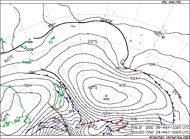
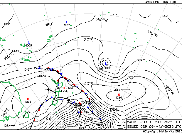
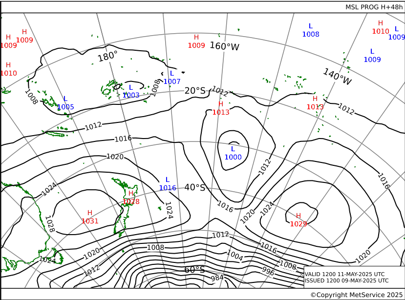
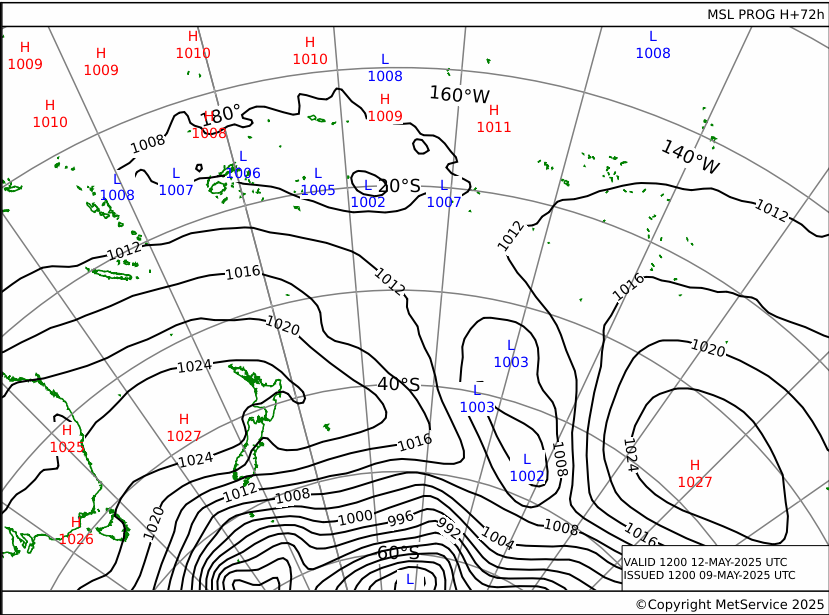
Weather Map from New Zealand MetService
update every 6 hours, normally at 02-08-14-20 UTC TIME:
-> Last Analysis Pressure chart Actual time
-> *www.y2ksail.com/imagesnzmet/actual.gif
-> +30 hours pressure forecast chart
-> *www.y2ksail.com/imagesnzmet/h30.gif
-> +48 hours pressure forecast chart
-> *www.y2ksail.com/imagesnzmet/h48.gif
-> +72 hours pressure forecast chart
-> *www.y2ksail.com/imagesnzmet/h72.gif
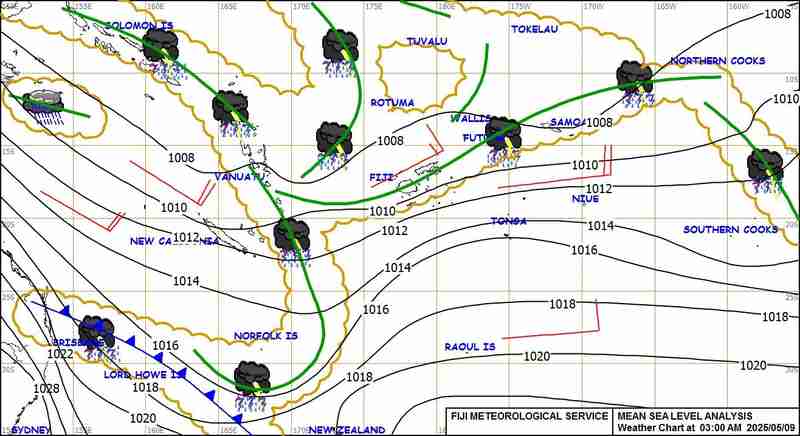
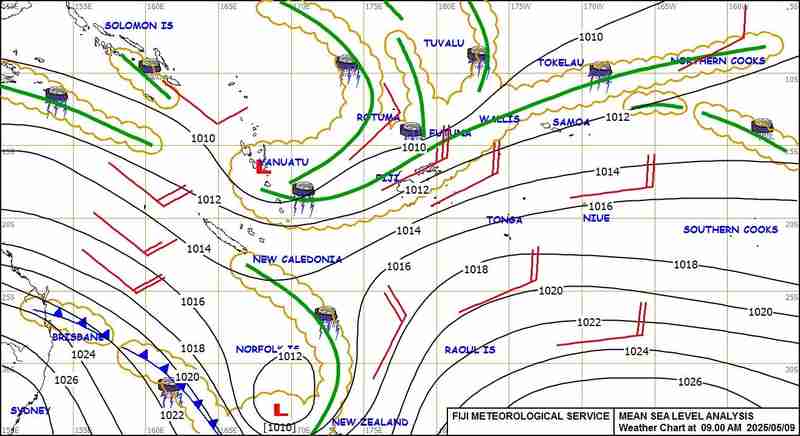
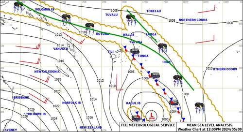
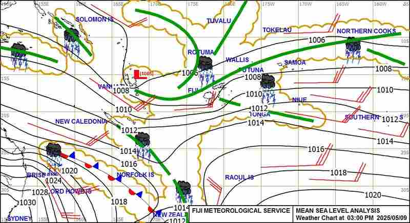
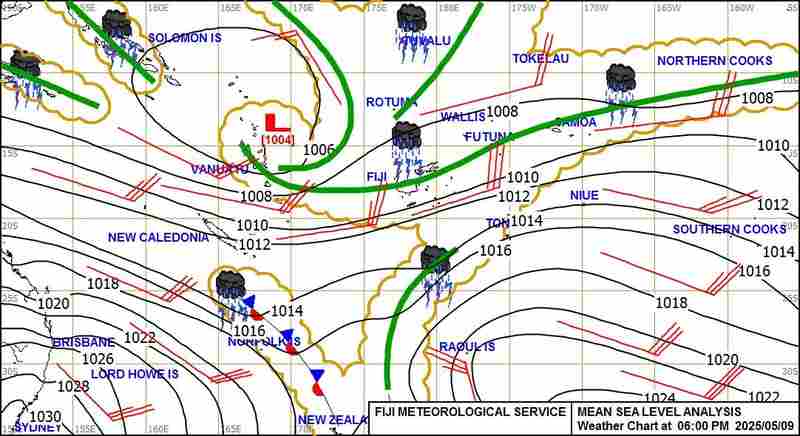
Weather Map coming from Fiji Met Service:
-> 3AM FST Surface Map available daily from 05.00am Fiji time
-> *www.y2ksail.com/imagesfijimet/3AM-small.jpg
-> 6AM FST Surface Map available daily from 09.30am Fiji time
-> *www.y2ksail.com/imagesfijimet/6AM-small.jpg
-> 09AM FST Surface Map available daily from 11.00am Fiji time
-> *www.y2ksail.com/imagesfijimet/9AM-small.jpg
-> 12PM FST Surface Map available daily from 03.00pm Fiji time
-> *www.y2ksail.com/imagesfijimet/12PM-small.jpg
-> 03PM FST Surface Map available daily from 05.00pm Fiji time
-> *www.y2ksail.com/imagesfijimet/3PM-small.jpg
-> 06PM FST Surface Map available daily from 08.30pm Fiji time
-> *www.y2ksail.com/imagesfijimet/6PM-small.jpg
-> 12AM FST Surface Map available daily from 03.00am Fiji time
-> *www.y2ksail.com/imagesfijimet/12AM-small.jpg
Enjoy
TROPICS
Cyclone MAWAR knocked out power in Guam and they are still in recovery mode.
It is about to sideswipe Taiwan.
The MJO, a burst of extra energy in the tropics, is now moving out of the
Pacific.
WEATHER ZONES
South Pacific Convergence zone SPCZ
The South Pacific Convergence zone is expected to do some rebuilding over
the Coral Sea to Fiji area this week. A trough might form south of Fiji on
Mon/Tue.
HIGHS and LOWS
High H1 to east of NZ is moving off top the southeast.
Low L1 in central Tasman is moving off to the south. Its associated front
has a NE gale over northern NZ tonight due to a squash between H1 and L1.
Low L2 is expected to form south of Gambier on Monday and deepen as it goes
SE.
HIGH H2 is expected to travel steadily across the North Tasman this week and
fade near Northland around Friday.
Late in the week L3 should cross the South Tasman Sea onto NZ, followed by
H3
The gulf of Panama = Light winds or SW winds this week=not much good for
Panama to Marquesas.
>>>>>>>>>>>>>>>>>>>>>>>>>>>>>>>>>>>
If you would like more details about your voyage, then check metbob.com to
see what I offer.
Or Facebook at /www.facebook.com/metbobnz/
Weathergram with graphics is at metbob.wordpress.com (subscribe/unsubscribe
at bottom).
Weathergram archive (with translator) is at weathergram.blogspot.co.nz.
Contact is bob@metbob.com or txt 64 277762212
>>>>>>>>>>>>>>>>>>>>>>>>>>>>>>>>>>>>>
28 May 2023
21 May 2023
Bob Blog 21 May
Bob McDavitt's ideas for sailing around the South Pacific.
Disclaimer: Weather is a mix of pattern and chaos; these ideas are from the
patterned world.
Compiled Sunday 21 May 2023
Bye Bye to Radiofax
The following is based on the MetService webpage
about.metservice.com/our-company/national-weather-services/retirement-of-rad
iofax
What is Radiofax
Radiofax (also known as HF Fax or Radiofacsimile) is an analogue broadcast
using high frequency (HF) radio waves to transmit images over long
distances. The technology is almost 100 years old and has been adapted for
telephone use as fax machines. The Radiofax service is one method that
MetService has used to transmit weather maps.
Nowadays, Radiofax equipment is scarce, difficult to service, costly to
maintain (especially transmitting equipment), and the technology has now
been superseded by the likes of HF email or satellite-based internet.
Retirement of Radiofax
MetService will retire its Radiofax broadcast service from 1 July 2023.
The MetService weather maps transmitted through Radiofax will however
continue to be produced and available on the metservice.com website also on
a low bandwidth page which is designed for users with more limited or paid
data connections (such as via satellite) to minimize download size and cost.
What's not changing?
The more safety critical oceanic/high seas warnings and forecasts (English
text) will continue to be produced and broadcast through all existing
channels/services, including internet, email, radio broadcast, and satellite
broadcast under the International Maritime Organization's (IMO) Global
Maritime Distress and Safety System (GMDSS). For more information about the
GMDSS, see the World Meteorological Organization's (WMO) website for the
Worldwide Met-Ocean Information and Warning Service (WWMIWS).
If you would like to get in touch with MetService about this change, please
contact radiofax@metservice.com
Modern solutions
Satellite phones and internet connections enable up to date weather
information and forecasts (such as maps of pressure, wind and waves) to be
directly displayed within onboard Chart plotters or Multi-Function Displays
(MFDs). These can now provide skippers with a much richer source of
information that can be integrated with other navigational maps and vessel
data in digital devices.
To request a download of the latest SUBTROPIC high seas forecast, send an
email to query@saildocs.com, with message:
SEND https://tgftp.nws.noaa.gov/data/raw/fq/fqps43.nzkl..txt
For NZ COASTALS SEND https://www.rnz.co.nz/news/weather/coastal
TROPICS
Cyclone MAWAR is expected to cross over GUAM on Tuesday night/Wednesday then
move to northwest. FABIEN has formed in the South Indian Ocean and is
somewhat out of season.
The MJO, a burst of extra energy in the tropics, is travelling across the
Pacific this week.
WEATHER ZONES
South Pacific Convergence Zone SPCZ
The South Pacific Convergence zone is expected to do some rebuilding over
the Coral Sea to Fiji area this week. A trough might form near New Caledonia
late in the week and cross Fiji and Tonga over the weekend or early next
week.
HIGHS and LOWS
Another busy week for Tasman troughs.
Low L1 is forming tonight on a cold front now half-way across the Tasman and
expected to deepen to 995 NW of Auckland by Monday night, then move off to
the east on Tuesday. Avoid. Its tight isobars will generate large swells. A
burst of 3+m swells may reach Noumea on Tuesday and Minerva on Wednesday.
High H1 should move over central NZ on Thursday, bringing a brief respite.
Low L2 is expected to form on a cold front when it reaches Sydney on Friday,
and then move into the central Tasman Sea over the weekend. More swell.
The gulf of Panama = Light winds or SW winds this week=no good for Panama to
Marquesas.
>>>>>>>>>>>>>>>>>>>>>>>>>>>>>>>>>>
If you would like more details about your voyage, then check metbob.com to
see what I offer.
Or Facebook at /www.facebook.com/metbobnz/
Weathergram with graphics is at metbob.wordpress.com (subscribe/unsubscribe
at bottom).
Weathergram archive (with translator) is at weathergram.blogspot.co.nz.
Contact is bob@metbob.com or txt 64 277762212
>>>>>>>>>>>>>>>>>>>>>>>>>>>>>>>>>>>>>
14 May 2023
Bob Blog 14 May
Bob McDavitt's ideas for sailing around the South Pacific.
Disclaimer: Weather is a mix of pattern and chaos; these ideas are from the
patterned world.
Compiled Sunday 14 May 2023
THE AUTUMN FLUSH
When a cold showery southerly outbreak rattles the windows in Auckland and
Northland in May, tons of yachts take that as their signa and head off for
the tropics.
1. There has been a blocking High east of NZ
2. Then along come s a kicker of a Low
3. The SW flow and incoming High that follow is "just right" for sailing
from NZ to the tropics.
The New Zealand weather clusters the yachts together and this makes an
interesting spectacle on the marine traffic maps:
There is also the rush of yachts from the east, lighting up the entire South
Pacific
It may be only 5% or so of the traffic on the planet, but these pink yachts
do stand out.
Welcome to the south Pacific and its wondrous weather systems.
TROPICS
Cyclone MOCHA is making landfall on the Bangladesh and Myanmar coasts
tonight.
And a tropical depression is likely to form on the Southern Indian Ocean
this week.
The MJO , a burst of extra energy in the tropics, is travelling from North
Australia into the Pacific, and this MIGHT help trigger a tropical
disturbance near Guam late this week.
WEATHER ZONES
The South Pacific Convergence zone is expected to do some rebuilding over
the Coral Sea to Fiji area this week. There is also a convergence zone
combined with a squash zone just south of Tahiti, but this is weakening.
A busy week for Tasman troughs.
High H1 tonight in the Tasman sea is expected to travel NE then east and
fade.
Low L1 is forming east of NZ tonight and expected to travel northeast and
weaken.
Low L2 and its front and cold air ate expected to cross Tasmania on
Monday/Tuesday and stall over southern NZ on Wednesday.
Low L3 is the main one this week and should start just as a trough off the
Queensland coast on Tuesday then deepen into a low and travel towards
central NZ, maybe reaching 980 off the Westland coast on Friday.
Its associated tropical trough should cross New Caledonia on Thursday and
Fiji to Minerva on Friday/Saturday.
After next weekend when L3 moves off to the east, the following SW flow and
incoming High make a good pattern for sailing from NZ to the tropics.
Panama to Marquesas: maybe a northerly flow in the Panama gulf from mod
week, but SW winds now reach to around 1north.
>>>>>>>>>>>>>>>>>>>>>>>>>>>>>>>>>>>
If you would like more details about your voyage, then check metbob.com to
see what I offer.
Or Facebook at /www.facebook.com/metbobnz/
Weathergram with graphics is at metbob.wordpress.com (subscribe/unsubscribe
at bottom).
Weathergram archive (with translator) is at weathergram.blogspot.co.nz.
Contact is bob@metbob.com or txt 64 277762212
>>>>>>>>>>>>>>>>>>>>>>>>>>>>>>>>>>>>>
07 May 2023
Bob Blog 7 May
Bob McDavitt's ideas for sailing around the South Pacific.
Disclaimer: Weather is a mix of pattern and chaos; these ideas are from the
patterned world.
Compiled Sunday 7 May 2023
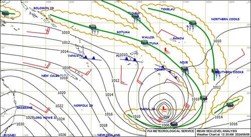
SQUASH ZONES
When sailing from Tahiti to Tonga there are strange weather features to
avoid.
A couple of weeks ago I introduced the SPCZ.
This week is a good week to talk about SQUASH ZONES
I got an email a few days ago asking:
"This is next week's forecast for Society and Tuamotus.
How is it possible to have 50kt winds (gusts) so close to absolute calm?
What on earth will be happening at that interface??"
And here is my reply
The satellite imagery and isobars give clues as to what's going on :
A BFH (Big Fat High) well south of French Polynesia with central pressure
near 1040hPa has been dominating the weather map for past 10 days.
It is now being nudged east and Isobars on its northern side are coming ng
closer together to allow the BFH passage.
This is not a frontal system nor a convergence zone nor a weather bomb (a
weather bomb requires pressure to fall 24hPa in 24hr).
It's what I call a SQUASH ZONE .
This squeezing of the isobars is occurring most within the cloud canopy seen
on the satellite image and a small low is expected to form near Papeete,
producing a lull just north of the squash zone.
Note the interesting thing that in the lull-of-no-wind the baro is going
down slowly, and in the zone of maximum gusts the isobars are stationary, so
the baro is steady.
Further south where the wind is increasing the baro is rising.
Welcome to the south Pacific and its wondrous weather systems.
TROPICS
South Pacific Convergence Zone SPCZ
The South Pacific Convergence zone is expected to be divided into sections
this week. The Main zone should rebuild over Coral sea and stretch across
Vanuatu towards Fiji. It might help form a low near Fiji early next week. A
Convergence zone is coming and going around Northern Cooks.
HIGHS and LOWS
A BFH (big fat High) H1 is lingering east of NZ and south of FP and this
week is finally expected to be nudged to the east. It has a squash zone on
its northern side near the Austral Islands. Avoid.
Low L1 is deepening off the Sydney coast tonight and expected to curve NE
then E across central NZ mid-week so that its wet and windy front crossed
North Island on Tuesday. Avoid.
It should then form L2 between Cook Strait and Chathams and that is expected
to deepen as it and L1 go off to the southeast.
In the wake of these Lows a vigorous southerly is expected across the
Tasman Sea reaching South Island on Wednesday and North Island on Thursday.
Another High H2 should reach Tasmania late Wednesday and then travel east
along 45S reaching South Island by Saturday.
The best day this week for departing NZ is Friday. However, there are early
indications that a Low may form near Fiji early next week and that could put
a spanner in the works. Check that before departure.
Panama to Marquesas: Good northerly flow fades mid-week, then we have
missed the bus and may as well wait for at least another week.
>>>>>>>>>>>>>>>>>>>>>>>>>>>>>>>>>>>
If you would like more detail for your voyage, then check metbob.com to see
what I offer.
Or Facebook at /www.facebook.com/metbobnz/
Weathergram with graphics is at metbob.wordpress.com (subscribe/unsubscribe
at bottom).
Weathergram archive (with translator) is at weathergram.blogspot.co.nz.
Contact is bob@metbob.com or txt 64 277762212
>>>>>>>>>>>>>>>>>>>>>>>>>>>>>>>>>>>>>
Disclaimer: Weather is a mix of pattern and chaos; these ideas are from the
patterned world.
Compiled Sunday 7 May 2023
SQUASH ZONES
When sailing from Tahiti to Tonga there are strange weather features to
avoid.
A couple of weeks ago I introduced the SPCZ.
This week is a good week to talk about SQUASH ZONES
I got an email a few days ago asking:
"This is next week's forecast for Society and Tuamotus.
How is it possible to have 50kt winds (gusts) so close to absolute calm?
What on earth will be happening at that interface??"
And here is my reply
The satellite imagery and isobars give clues as to what's going on :
A BFH (Big Fat High) well south of French Polynesia with central pressure
near 1040hPa has been dominating the weather map for past 10 days.
It is now being nudged east and Isobars on its northern side are coming ng
closer together to allow the BFH passage.
This is not a frontal system nor a convergence zone nor a weather bomb (a
weather bomb requires pressure to fall 24hPa in 24hr).
It's what I call a SQUASH ZONE .
This squeezing of the isobars is occurring most within the cloud canopy seen
on the satellite image and a small low is expected to form near Papeete,
producing a lull just north of the squash zone.
Note the interesting thing that in the lull-of-no-wind the baro is going
down slowly, and in the zone of maximum gusts the isobars are stationary, so
the baro is steady.
Further south where the wind is increasing the baro is rising.
Welcome to the south Pacific and its wondrous weather systems.
TROPICS
South Pacific Convergence Zone SPCZ
The South Pacific Convergence zone is expected to be divided into sections
this week. The Main zone should rebuild over Coral sea and stretch across
Vanuatu towards Fiji. It might help form a low near Fiji early next week. A
Convergence zone is coming and going around Northern Cooks.
HIGHS and LOWS
A BFH (big fat High) H1 is lingering east of NZ and south of FP and this
week is finally expected to be nudged to the east. It has a squash zone on
its northern side near the Austral Islands. Avoid.
Low L1 is deepening off the Sydney coast tonight and expected to curve NE
then E across central NZ mid-week so that its wet and windy front crossed
North Island on Tuesday. Avoid.
It should then form L2 between Cook Strait and Chathams and that is expected
to deepen as it and L1 go off to the southeast.
In the wake of these Lows a vigorous southerly is expected across the
Tasman Sea reaching South Island on Wednesday and North Island on Thursday.
Another High H2 should reach Tasmania late Wednesday and then travel east
along 45S reaching South Island by Saturday.
The best day this week for departing NZ is Friday. However, there are early
indications that a Low may form near Fiji early next week and that could put
a spanner in the works. Check that before departure.
Panama to Marquesas: Good northerly flow fades mid-week, then we have
missed the bus and may as well wait for at least another week.
>>>>>>>>>>>>>>>>>>>>>>>>>>>>>>>>>>>
If you would like more detail for your voyage, then check metbob.com to see
what I offer.
Or Facebook at /www.facebook.com/metbobnz/
Weathergram with graphics is at metbob.wordpress.com (subscribe/unsubscribe
at bottom).
Weathergram archive (with translator) is at weathergram.blogspot.co.nz.
Contact is bob@metbob.com or txt 64 277762212
>>>>>>>>>>>>>>>>>>>>>>>>>>>>>>>>>>>>>
Subscribe to:
Posts (Atom)