Bob McDavitt's ideas for sailing around the South Pacific.
Disclaimer: Weather is a mix of pattern and chaos; these ideas are
from the patterned world.
Compiled Sunday 28 April 2024
WESTWARD HO . for those planning to get from Tahiti to Tonga
An introduction to the South Pacific Convergence Zone (What and Why)
Now that the cyclone season finishes mid-week, many yachts are about
to travel west from Tahiti to Tonga, and are thus about to sail thru
or around the SPCZ, this obstacle has become a talking point.as if it
guards the eastern entrance to the South Pacific like a protective
dragon or demon, and some have asked what is it, why is it there, how
does it differ from the ITCZ and what makes it tick.
Weather is a mix of pattern and chaos, and meteorologists concentrate
on the pattern.
In tropical meteorology the first idea given is the Hadley cell.
Recipe for the ITCZ
1. Because the sun is most directly overhead near the equator, that's
where the warmest seas are, and this causes rising air.
2. Once the rising air reaches high enough it spreads outwards and
sideways to the north or south, where it sinks at dries out.
3. The sinking air reaches the surface again around 30N or 30S
(subtropical ridge) and then recirculates back to the equator as
surface winds know as trade winds.
4. The trade winds from each hemisphere converge together in a zone,
and this convergence narrows the zone of rising air into a feature
called the Intertropical Convergence Zone or ITCZ
But in the Southern Hemisphere, the Andes of South America cause a
split in the trade winds. They block a HIGH near 30S around 90 to
110W, or south of Easter Island. It is quasi stationary, just like the
High between California and Hawaii, and has a gyre that collects a
rubbish heap just as badly (see Henderson Island:
blogs.fco.gov.uk/lauraclarke/2018/04/10/henderson-island-plastic-pollu
tion-in-paradise/).
Recipe for the SPCZ
1. There are easterly winds on the north side of this "Andes" High:
they are dry due to continental outflow from off South America. These
easterly winds travel well to west of the dateline along around 10 to
15S.
2. And there are migratory Highs that travel east along the
subtropical ridge from Australia to east of NZ, with a zone of south
to southeast winds on their northern side. These South/SE winds come
and go according to the migratory high and are usually found around 15
to 25S.
3. The convergence zone between these easterly and Southeasterly winds
is called the South pacific Convergence Zone, or SPCZ.
It is typically located from the Solomon Islands south-eastwards to
the Southern Cooks, and is around 1 to 5 degrees latitude wide, but
sometimes may have large gaps or be very quiet.
It is affected by many things:
. the Pacific Decadal Oscillation or PDO which takes many years to
switch.
. the El Nino/La Nina which lasts a year or so.
. the strongest cycle is the ANNUAL cycle as earth orbits the sun,
making the seasons.
. and the MJO which comes for a week or so every six weeks or so.
Read more about it at
en.wikipedia.org/wiki/South_Pacific_convergence_zone
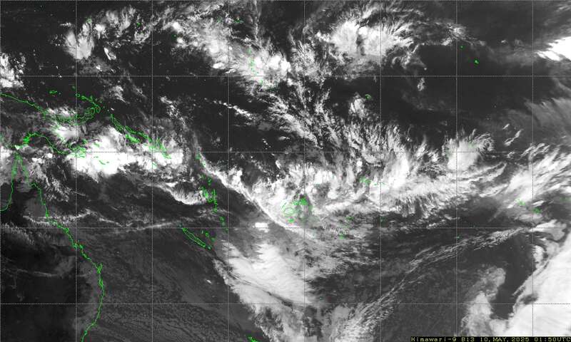
I have found that the easiest way to determine the position and
severity of the SPCZ is to use satellite imagery, and the easiest way
to decide what it may do over next few days is to use the 5day rain
accumulation parameter on windy.com.
The latest Satellite image of the SPCZ is available as a small
attachment via an email request.
Send an email to query@saildocs.com with the message (no subject line
needed)
SEND https://www.y2ksail.com/himawari/latest-SpacificLarge-small.jpg
In a future blog I'll compare and contrast the three routes from
Tahiti to Tonga: when to take or avoid the northern, direct or
southern route and how to decide which is best over the week ahead.
TROPICS
It is a quiet time with no named cyclones.
WEATHER ZONES
The South Pacific Convergence zone is active from Northern Coral Sea
to northern Vanuatu to south of Fiji, with another arm over Northern
Cooks. There is a passing trough to southeast of Tahiti.
HIGHS and LOWS
HIGH H1 over Chathams tonight is expected to travel ESE from 43S to
50S leaving a ridge over central NZ.
Low L1 is deepening between northern NZ and Tonga on Monday and then
travelling SE, peak central pressure below 995 when east and well
offshore of Gisborne on Wednesday. From Thursday as L1 moves away a
trough is expected to cross NZ followed by SW swells over 3m extending
north and reaching New Caledonia by the weekend.
Low L2 I expected to form off the eastern seaboard of Australia around
Friday with associated trough traveling east across Lord Howe Monday 6
May
Looking Ok this week for getting from NZ to the tropics, maybe going
around L1.
If planning a Trans-Tasman trip going east, then work in with L2.
Looking Ok for getting from NZ to the tropics,
Panama to Marquesas:
Only light winds for starters this week.
Doldrums between Panama and 2N with erratic winds and squally showers.
.>>>>>>>>>>>>>>>>>>>>>>>>>>>>>>>>>>>
If you would like more details about your voyage, then check
metbob.com to see what I offer.
Or Facebook at /www.facebook.com/metbobnz/
Weathergram with graphics is at metbob.wordpress.com
(subscribe/unsubscribe at bottom).
Weathergram archive (with translator) is at
weathergram.blogspot.co.nz.
Contact is bob@metbob.com or text 64277762212.
>>>>>>>>>>>>>>>>>>>>>>>>>>>>>>>>>>>>>
28 April 2024
21 April 2024
Bobgram
Bob McDavitt's ideas for sailing around the South Pacific.
Disclaimer: Weather is a mix of pattern and chaos; these ideas are
from the patterned world.
Compiled Sunday 21 April 2024
SOI is changing.
It's now official. The El Nino of last year is now over and we are in
neutral territory. El Nino is the name given to the period when sea
surface temperatures over the eastern equatorial Pacific are above
normal. A good measure of this is the Nino 3.4 index. The graph shown
here from the Bureau of Meteorology, Australia has the Nino 3.4
measurements and calculated trends from an ensemble of computer
models. Neutral conditions are in the offering for winter and spring,
and there may be a swing to La Nina next summer,
The SOI or Southern Oscillation index comes directly from the isobars
found on a weather map. It measures the difference in barometric
pressure readings between Tahiti and Darwin, basically giving an idea
of the strength of the trade winds.
It has been in El Nino (negative) territory since last May, and has
relaxed to neutral in the past month.
Climate experts say that the relaxing of the El Nino help them
determine if the recent unprecedented high temperatures worldwide have
been due to accelerated climate change or not. NOAA predicts there is
an 85% chance the El Niño warmth will be gone sometime before June,
while Australia's Bureau of Meteorology says the tropical Pacific sea
surface already "cooled substantially" during mid April. The absence
of that heat will reduce the vertical wind shear that typically
squashes hurricane and tropical storm development in the Atlantic
Basin, possibly leading to a very active hurricane season.
During the "neutral" period for the next few months the weather is
likely to swing from one pattern to another, allowing variety as each
pattern gets to "play" for a short time. I call this "weather Jazz"
TROPICS
It is a quiet time with no named cyclones. There is a weak MJO
crossing the Pacific longitudes this week, and a slight increase is
cyclone potential around New Caledonia.
WEATHER ZONES
It's a busy weather map this week with four lows: 2 in the tropics and
2 in the mid- latitudes.
The South Pacific Convergence zone is active between New Caledonia and
Southern Cooks, and is breeding tropical lows, as is typical during an
MJO pulse. Low L1 is expected to form south of Fiji on Monday and then
travel east and fade away over Niue area by mid-week. Low L2 is
currently in the Coral Sea and expected to deepen over New Caledonia
mid-week and then travel SE to the east of NZ by weekend. Avoid.
HIGHS and LOWS
Low 3 travelled over northern NZ in past few days and is moving off to
the SE.
HIGH H1 is in the Tasman Sea and expected to travel across northern NZ
mid-week and then move off to the east along 35 to 40 South.,
shepherding L2 towards SE of NZ by weekend.
Low L4 is expected to cross Tasmania on Wednesday and its associated
trough should cross NZ on Thursday and Friday and connect with L2 then
to north of NZ. Avoid.
If planning a Trans Tasman trip then work in with H1.
If planning to sail from NZ to tropics wait until after L2.
Panama to Marquesas: Northerly winds for starters. Doldrums between
6N and 2N with erratic winds and squally showers.
.>>>>>>>>>>>>>>>>>>>>>>>>>>>>>>>>>>>
If you would like more details about your voyage, then check
metbob.com to see what I offer.
Or Facebook at /www.facebook.com/metbobnz/
Weathergram with graphics is at metbob.wordpress.com
(subscribe/unsubscribe at bottom).
Weathergram archive (with translator) is at
weathergram.blogspot.co.nz.
Contact is bob@metbob.com or text 64277762212.
>>>>>>>>>>>>>>>>>>>>>>>>>>>>>>>>>>>>>
14 April 2024
Bobgram 14 April
Bob McDavitt's ideas for sailing around the South Pacific.
Disclaimer: Weather is a mix of pattern and chaos; these ideas are
from the patterned world.
Compiled Sunday 14 April 2024
A review of the cyclone season
A time-map shows the cyclones that affected the Australian and South
pacific regions during the cyclone season that started on 1 November
2023 and ends on 30 April 2024.
VANUATU had a hard time in 2023 with three severe storms: Judy and
Kevin in March, then Lola in October. Then in November Mal brought
some minor damage to Fiji.
During this cyclone season none bothered New Zealand (unlike last
season). The main damaging cyclones this season were around Australia.
This was an El Nino year, and such years are sometimes "below par" for
tropical cyclones in NZ.
It is interesting to compare these cyclone clusters and damaging
cyclones with the passing MJO (Madden Julian Oscillation) pulses,
shown here as blue zones in the OLR (outgoing longwave radiation)
anomalies, from
www.cpc.ncep.noaa.gov/products/precip/CWlink/MJO/mjoupdate.pdf.
Basically, the denser the tropical clouds, the lesser is the satellite
measured OLR. We had four MJO pulses is the past cyclone season, and
each triggered a severe cyclone within the Australian area,
When a MJO pulse arrives in our part of the world, there is a higher
tendency for tropical cyclones to be triggered. It is just a tendency
- it doesn't always work--and cyclones can form without the MJO --,
but it is a useful indicator, as shown in the MJO's we had this season
and the main cyclones that affected Australia.
TROPICS
Cyclone Olga attained Category-4 force over the Eastern Indian Ocean.
. Tropical Storm Paul spun up briefing in the Coral Sea.
WEATHER ZONES
The South Pacific Convergence zone is being rebuilt in the Coral Sea
to north of Fiji and has an active zone across central areas of French
Polynesia until mid-week. Avoid.
HIGHS and LOWS
The low that travelled over central NZ last few days is now moving off
to the east and by mid-week a new low L1 is expected to form well
south of Niue and then move off the southeast following the former
Low.
Part of HIGH H1 is travelling east along 30 to 35S past the north of
NZ next few days and weakening. Later this week it is expected to be
followed by the remainder of H1.
A trough is expected to form along East Australian coast on Thursday
and then cross the Tasman Sea and NZ on Friday followed by strong SW
flow on Saturday.
Then, High H2 is expected to travel from Australian bight into the
Tasman Sea by end of the week.
Panama to Marquesas:
Some good northerly winds for starters until mid-week, then just light
winds until Friday 26 April.
Doldrums between 5N and equator, occasionally squally west of 100W and
between 7N and 3N.
Also, west of 100W as far as 125W is a mirror ITCZ between 3S and 8S.
.>>>>>>>>>>>>>>>>>>>>>>>>>>>>>>>>>>>
If you would like more details about your voyage, then check
metbob.com to see what I offer.
Or Facebook at /www.facebook.com/metbobnz/
Weathergram with graphics is at metbob.wordpress.com
(subscribe/unsubscribe at bottom).
Weathergram archive (with translator) is at
weathergram.blogspot.co.nz.
Contact is bob@metbob.com or text 64277762212.
>>>>>>>>>>>>>>>>>>>>>>>>>>>>>>>>>>>>>
07 April 2024
Bob Blog 7 April
Bob McDavitt's ideas for sailing around the South Pacific.
Disclaimer: Weather is a mix of pattern and chaos; these ideas are
from the patterned world.
Compiled Sunday 7 April 2024
A review of last month's weather
Here is a link to a YouTube clip giving an animated loop of the
isobars and streamlines in the South Pacific for the last month at
youtu.be/xT9TJdZYcwE
March was a quiet month in the South Pacific tropics. There was a
brief MJO in the middle of the month which rejiggered cyclone NEVILLE
off NW Australia and MEGAN which peaked in western Gulf of
Carpentaria.
The SST pattern shows more yellow/red than blue when looking at
anomalies using the 30yer ending 2020 as the base. That, in itself,
shows global warming. Regionally, there is some cool waters showing
off the Galapagos, a sign of the beginning of a swing from El Nino to
La Nina. Also. the sea around NZ is returning to about normal and
there is a swath of below normal around 20S across the South Pacific.
Average isobars for past month (below)
During March the subtropical ridges in both hemispheres were well
marked.
The anomaly pressure pattern for March shows high pressured over Aus
Bight ad Tasman Sea , and low pressures east of NZ, thus a
predominance of SW winds over NZ. It was still through to SE of Tahiti
but the remainder of SPCZ was around normal.
Last month
The 1015 isobar has shifted north over Australia from 37S to 30S
,showing the seasonal shift in the subtropical ridge.
The Antarctic high has increased from 1010 to 1030 so the isobars are
squeezed closer together around 50S.
TROPICS
Cyclone Gamane killed at least 18 people in Madagascar and triggered
severe flooding that partially submerged villages on March 27.
OLGA is moving SW off the NW Australian coast.
WEATHER ZONES
The South Pacific Convergence zone is being rebuilt in the Coral Sea.
And has an active branch between Tonga and Tahiti. A tropical low L1
is likely to form on this branch late this week and travel south.
HIGHS and LOWS
HIGH H1 near Chatham Islands is expected to drift slowly east along
40S and reach a peak of 1036 on Thursday. It should have a squash zone
of enhanced easterly winds on its northern side between 20 and 25S
with swells over 3m. Avoid.
There is a trough off NSW (it brought flooding around Sydney on
Friday). It is expected to develop a low L2 near 160E on Tuesday. The
trough is preceded by strong NE to NW winds over NZ on Tuesday and
Wednesday, may be accompanied by rain on Thursday and Friday, and
followed by southerlies on Friday night and Saturday. Avoid.
HIGH H2 is moving in from the west along 40S and expected to reach
central Tasman Sea by Saturday.
Panama to Marquesas:
Avoid departing on Tuesday as it may be squally. Then Wednesday and
Thursday may only have light wind. From Friday a period of goo looking
northerly winds is expected to last to around Sat 20 April, good to
go, but showery from 7N to 5N.
>>>>>>>>>>>>>>>>>>>>>>>>>>>>>>>>>>>
If you would like more details about your voyage, then check
metbob.com to see what I offer.
Or Facebook at /www.facebook.com/metbobnz/
Weathergram with graphics is at metbob.wordpress.com
(subscribe/unsubscribe at bottom).
Weathergram archive (with translator) is at
weathergram.blogspot.co.nz.
Contact is bob@metbob.com or text 64277762212.
>>>>>>>>>>>>>>>>>>>>>>>>>>>>>>>>>>>>>
Subscribe to:
Posts (Atom)