Bob McDavitt's ideas for sailing around the South Pacific.
Disclaimer: Weather is a mix of pattern and chaos; these ideas are from the
patterned world.
Compiled Sunday 25 April (ANZAC day in Australia and NZ. My Dad escaped as a
POW in WW!! (but not for long).
Getting followed and following the Weather for CRUISING SAILORS
Fingers crossed and conditions permitting, there will be several sailors
planning to depart Opua and head for Fiji in May.
So, this is a good time to review ways to obtain weather information and
provide position reports.
The COVID 19 pandemic and port closures
Things keep changing. The best source I know for the latest information is
www.noonsite.com
A: Getting Followed
YiT (Yachts in Transit) unfortunately closed in December 2020. Pacific
Maritime Radio (was known as Northland Radio) ZMH292 is closed until 2022
(Peter is relocating).
If you wish your friends to be able to follow your path at sea then arrange
registration for this before departure.
If you have AIS then your friends can see your path on tracking sites such
as marinetraffice.com (they charge a fee for satellite updates).
1.SHORTWAVE/Marine Radio
Do you have a Radio Operator License/Callsign in NZ starting with ZM?
ZLM/Taupo Maritime Radio has a continuous Trip reporting service see
www.maritimenz.govt.nz/about/what-we-do/safety-and-response/maritime-radio.a
sp
Gulf Harbour Radio ZMH286 offers a SSB radio check in service with weather.
Patricia and David keep track of boats that listen to their rollcall/weather
service.
You may register before travel and then email your reports in via
ghradio@xtra.co.nz or weather@ghradio.co.nz
FROM 1 MAY to 25 NOV 2021 Patricia/Dave intend to be on air on ZMH286 on
8752Khz or 8779KHz or 8297KHz in that order depending on interference.
Mon-Fri. Patricia tells me the timing may be later than last year's
0715NZST. The ghradio.co.nz website offers live streaming and has several
good background weather& radio & comms articles.
2. AMATEUR/Ham RADIO
Do you have an Amateur Radio Operations Certificate? Callsign in NZ starting
with ZL?
PACSEANET or The Pacific Seafarers' Net is a ham (amateur radio) network
providing a free of charge check in service on amateur frequency 14300kHz
USB in the 20metre band at 0300UTC. Position reports are received and
reported in the well-know YOTREPS format (but missed calls may not be
followed up). The net features 12 listening station dotted between Australia
and Alabama. See pacseanet.blogspot.com
WinLink (winlink.org) Is a well-known, reliable amateur radio link that
works via Internet and via radio, supporting email with attachments,
position reporting using YOTREPS, and weather and information bulletins. It
runs by connecting a Pactor modem to your ham radio.
Tony's Maritime net, a ham net, is on 14315kHz USB at 2100UT for check-in
and general chit chat. Everyday. It is a lot less formal than PacSeaNet and
has relay stations on both sides of the Tasman to handle boats between us
and in the SW Pacific
3. Smart phone apps: Some satellite phones now provide wifi that allow
nearby smart phones to use apps. Predictwind (www.predictwind.com) offers
access to weather forecasting (6 global models and 5 regional models),
observations, tracking and routing. Other Apps are
https://www.weathertrack.us/, https://www.weather4d.com/,
https://www.sailgrib.com/, http://pocketgrib.com/, https://inavx.com/, and
windy.app
4. TXT messages Satellite phones Garmin inReach and Iridium Go allow SMS
text messages. If that's you then consider followingsea.net, this site
offers both position reporting and weather information.
B: Following the Weather
1. Internet. When you are in the marina and have WiFi connection to the
Internet and are seeking a reasonable weather pattern for a good departure,
use windy.com to review the weather as seen by three global models covering
the next ten days. It's basic services are free of charge and has a planned
route plot option using EC model (Menu, distance & planning, start and
finish, boat, select speed--- assumes constant speed, no polars, click more
options (bottom left) and ensure wind is "north up")
2. HF Radio: Anyone can LISTEN to the HIGH SEAS warnings and forecasts
for the area SUBTROPIC FOURTIES and PACIFIC from MetService is read out in
English via ZLM at 0903hr, and 2103hr NZST/NZDT on 6224 and 12356KHz and
repeated an hour later on 8297 and 16531 KHz.
A copy of the Radiofax sked is at
https://www.metservice.com/marine/radio-schedule
Here is a current map of the forecast boundaries.
3. EMAIL: Saildocs (saildocs.com) can relay the text details of a
webpage even if you only have email and no access to the Internet.
See weather.mailasail.com/Franks-Weather/Home, and read how to download and
view GRIB files.
A good reference showing how saildocs can be used to obtain GRIB data and
weather maps is at https://tinyurl.com/FPweatherComp (section 31).
Saildocs allows you, for example, to obtain the text of the latest edition
of MetService NZ Coastal forecasts
by sending an email to query@saildocs.com, subject: anything you like, with
message body: SEND https://www.rnz.co.nz/news/weather/coastal
For latest Fiji land area forecasts SEND
https://www.met.gov.fj/aifs_prods/10040.txt
For latest Fiji marine forecast SEND
https://www.met.gov.fj/aifs_prods/10060.txt
For South West Pacific High Seas Forecast or ISLANDS area SEND
https://www.met.gov.fj/aifs_prods/10140.txt
For Meteo France New Caledonia Blue water High Seas in French SEND
https://www.y2ksail.com/newcal/latest-large-meteo.htm
For MetService subtropics High Seas area use SEND
http://tgftp.nws.noaa.gov/data/raw/fq/fqps43.nzkl..txt
They also use code words. For High Sea forecasts use SEND nz.subtrop or SEND
nz.forties or SEND nz.pacific
Fiji Fleet code. This is a code that can be sent as an EMAIL and then
decoded into a manually constructed weather analysis map.
To download the latest Nadi Fleet code send an email to query@saildocs.com,
no subject needed, saying SEND nadi-fleetcode or SEND fleet.nadi
Or SEND https://tgftp.nws.noaa.gov/data/raw/as/asps20.nffn..txt This can be
viewed within the Fleet Code plug in OpenCPN (opencpn.org/)
Open the email and (on a PC) select and <Right> click the data, then <copy>
or CTRL-C. Then, in OpenCPN's IAC Fleet code plugin, there are 4 option:
Files, Text, Raw and Downloads. Select Raw and then <paste> or CTRL-V.
Voila!, the map appears. I still have a copy of the old, no longer
supported Fleet code viewing program call PhysPlot. If you want to try it,
let me know.
Saildocs can also send small attached weather maps of satellite images and
weather maps
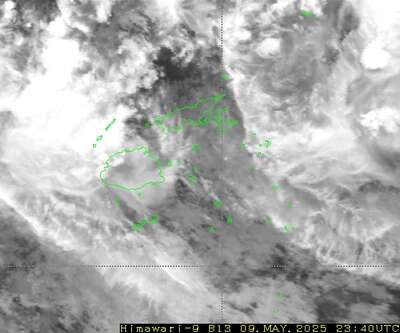
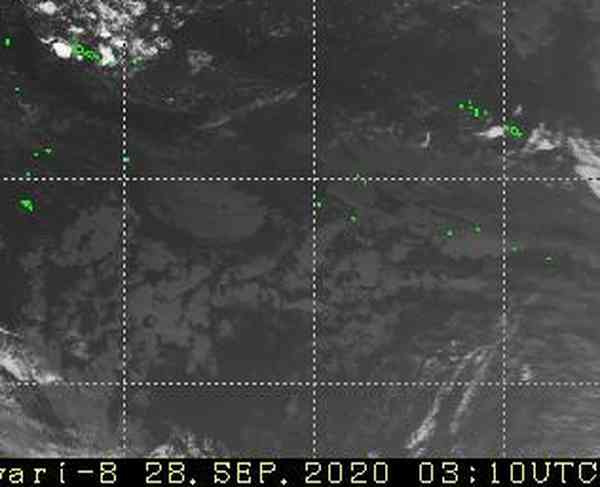
Satellite images: Fiji infrared image updated every 10 minutes SEND
https://www.y2ksail.com/himawari/latest-fiji-small.jpg
Area 10-40S and 160E to 160W updated every hour SEND
https://www.y2ksail.com/imagesfijisat/latest.jpg
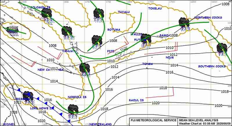
MSL Analysis maps: Fiji SEND
https://www.y2ksail.com/imagesfijimet/3AM-small.jpg also
6AM,9AM,12PM,3PM,6PM,12AM available around 3 hours after timestamp.
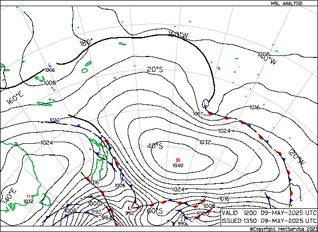
NZ latest SEND https://www.y2ksail.com/imagesnzmet/actual.gif updated
0200&0800&1400&2000UTC, also h30, h48, h72.gif
New Caledonia area SEND https://www.y2ksail.com/newcal/anafax-small.jpg
updated 0335&0835&1335&2035UTC+11
4. MetBob. Weather is a mix of pattern and chaos.
See my website at www.metbob.com to study my forecasting services.
WEATHERGRAM: These blogs are usually issued on a Sunday night NZ time with
my evaluation of weather patterns around the South Pacific.
They comment on what to AVOID and help pick windows of opportunity for good
sailing weather.
It is available in several different ways:
Internet illustrated edition is at metbob.wordpress.com, this has a
click-to-follow option.
Internet translator and archive is at weathergram.blogspot.com
On Facebook at www.facebook.com/metbobnz
Via Saildocs For a one-off: Send an email to query@saildocs.com, subject:
anything you like, with message body: SEND nz.wgrm or SEND nz-weathergram
To subscribe: use SUB nz.wgrm (or SUBSCRIBE nz.wgrm), To cancel: use CANCEL
nz.wgrm or UNSUB nz.wgrm or UNSUBSCRIBE nz.wgrm
Via SMS text. There are two options. For full text (Ok for Sat Phone or HF
SSB with sailmail/winlink) use weathergram@followingsea.net,
and for it reduced to 4 SMS text messages, (for Satellite messengers such
as Garmin inReach) use weathergram_short@followingsea.net
To subscribe, email to one of those email addresses, no subject needed with
message: subscribe boatname (where boatname is name of your vessel, up to 20
characters).
To unsubscribe, send the word UNSUBSCRIBE from your email address, or, if
you have access to Internet you can login and go to followingsea.net/Nets
and click on "Leave" button next to the net you want to leave. if you wish
to only receive the weathergram (and not be disturbed by messages from other
users) you can mute other calls by sending MUTE ON to the net address. To
unmute, send MUTE OFF.
See followingsea.net/docs for more info and info about location reports,
getting weather warnings and forecasts.
The Tropics
The latest cyclone activity report is at tropic.ssec.wisc.edu and Tropical
Cyclone Potential is from www.ssd.noaa.gov/PS/TROP/TCFP/index.html
TC SURIGAE continues to travel to the NE across the northwest Pacific.
There are some zones of potential development north of Australia and around
Vanuatu.
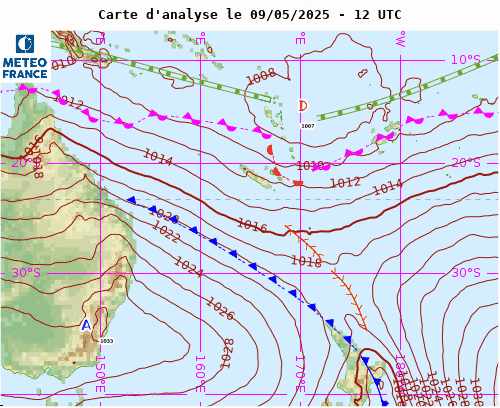
WEATHER ZONES
Weather Zones Mid-week GFS model showing isobars, winds, waves(magenta),
Rain (Blue), STR (Subtropical Ridge), SPCZ (South Pacific Convergence Zone)
and CAPE9 (in pink)
Predict wind CAPE mid-week gives two possibilities for SPCZ.
SPCZ=South Pacific Convergence zone.
The SPCZ is expected to stretch across the Coral sea /northern Vanuatu
/Fiji/Southern Tonga.
Low is expected to form over Fiji mid-week and travel southeast across tonga
around local Thursday.
Rain Accumulation next five days from windy.com
Subtropical ridge (STR)
HIGH in the Aussie Bight is expected to travel east along 40S, stall in
mid-Tasman and finally fade over northern NZ early next week.
This is expected to make a squash zone of enhanced SE winds off the northern
Queensland coast on Wednesday.
Aussie/Tasman/NZ troughs
Trough over North Island on Monday, followed by a trough over South Island
late Monday and North Island on Tuesday,
then a west to SW flow over the South and a S to SE flow north of 40S
- good for getting from NZ to tropics or Australia
--- but note that departures from NZ this week are likely to encounter a
trough near 20s next week.
Panama to Galapagos/Marquesas
Northerly winds over Panama to 5N until mid-week then light winds or
southerlies. S to SE winds between 5N and Galapagos.
In spite of these southerly winds, when taking the current into account, it
looks better to get to Marquesas via SOUTH of Galapagos this week.
>>>>>>>>>>>>>>>>>>>>>>>>>>>>>>>>>>>>>>>>>
If you would like more detail for your voyage, then check metbob.com to see
what I offer.
Or Facebook at /www.facebook.com/metbobnz/
Weathergram with graphics is at metbob.wordpress.com (subscribe/unsubscribe
at bottom).
Weathergram archive (with translator) is at weathergram.blogspot.co.nz.
Contact is bob@metbob.com or txt 64277762212
>>>>>>>>>>>>>>>>>>>>>>>>>>>>>>>>>>>>>>>>>>>>>>>>>>>>>>>
25 April 2021
18 April 2021
Bob Blog 18 April
Bob McDavitt's ideas for sailing around the South Pacific.
Disclaimer: Weather is a mix of pattern and chaos; these ideas are from the
patterned world.
Compiled Sunday 18 April
Firstly, as a memorial for Prince Phillip
www.youtube.com/watch?v=2dlXmuYuAYc
Hold your horses for now: As it says on www.noonsite.com/place/Australia ,
"while quarantine-free travel is to begin between Australia and NZ from 19
April, this is only permitted on commercial airlines. Border restrictions
remain in place for private flights and the maritime border". You can (try
and) seek an exemption - see-
www.customs.govt.nz/covid-19/maritime-border/private-yachts-and-small-craft/
guidance-for-small-craft-and-yacht-arrivals-in-new-zealand/#:~:text=Exemptio
ns%20for%20foreign%20vessels%20to%20enter%20New%20Zealand&text=Vessels%20may
%20be%20exempt%20if,or%20refitting%20the%20vessel%20AND
However, this is a constantly changing situation, so if we all cross our
fingers hard enough, maybe the bureaucracy will catch up with itself and
allow yachts into the trans-Tasman bubble.
If you are stuck in New Zealand and approaching your immigration
limitations, then join the facebook page
www.facebook.com/groups/41201881000740 for information.
The Tropics
The latest cyclone activity report is at tropic.ssec.wisc.edu and Tropical
Cyclone Potential is from www.ssd.noaa.gov/PS/TROP/TCFP/index.html
The MJO is still crossing the Pacific bringing a boost to tropical
convection. After killing over 34 people and bringing widespread flooding
to Timor Leste, SEROJA made landfall over Kalbarri , about 300 n miles north
of Pert, damaging 70% of its structures. It was joined by TC ODETTE,
producing a rare cyclone dance called a Fujiwhara (named after Sakuhei
Fujiwhara en.wikipedia.org/wiki/Sakuhei_Fujiwhara ) see
www.severe-weather.eu/tropical-weather/fujiwhara-effect-cyclone-seroja-odett
e-australia-landfall-mk/.
And now TC SURIGAE/BISING has brewed and is east of Philippines after
becoming the strongest April typhoon on record.
There are some zones of potential development dotted over the Pacific this
week, but, with luck, this MJO has already peaked.
WEATHER ZONES
SPCZ=South Pacific Convergence zone.
The SPCZ is expected to be broad across the Coral sea and northern Vanuatu
to Samoa and thinning out to a tight convergence zone across Southern Cooks
and southern parts of French Polynesia.
Passing trough is expected to visit New Caledonia on Monday and south of
Tonga during mid-week.
Subtropical ridge (STR)
HIGH to NE of NZ is expected to travel east along 35 to 40S and build to
1032hPa south of Tahiti, building a squash zone of enhanced trade winds
along 25S from 135W to 160W.
HIGH in the Aussie Bight is expected to send a brief ridge into northern
Tasman Sea for the week.
Another HIGH may start ridging cross Bass strait this weekend.
Aussie/Tasman/NZ troughs
Low between Lord Howe and Norfolk Islands is expected to fade over North
Island on Tuesday and Wednesday.
Trough crossing Tasmania on Monday is expected to deepen into a Low in
mid-Tasman Sea by Wednesday and then weaken into a trough over NZ by Friday,
followed by a SW flow.
Panama to Galapagos/Marquesas
Light winds around Panama until midweek the a period of northerly winds,
good for departure. S to SE winds between 5N and Galapagos.
Taking the current into account, it looks better to get to Marquesas via
NORTH of Galapagos this week.
>>>>>>>>>>>>>>>>>>>>>>>>>>>>>>>>>>>>>>>>>
If you would like more detail for your voyage, then check metbob.com to see
what I offer.
Or Facebook at /www.facebook.com/metbobnz/
Weathergram with graphics is at metbob.wordpress.com (subscribe/unsubscribe
at bottom).
Weathergram archive (with translator) is at weathergram.blogspot.co.nz.
Contact is bob@metbob.com or txt 6427 7762212
>>>>>>>>>>>>>>>>>>>>>>>>>>>>>>>>>>>>>>>>>>>>>>>>>>>>>>>
10 April 2021
Bob Blog 11 April
Bob Blog 11 April
Bob McDavitt's ideas for sailing around the South Pacific.
Disclaimer: Weather is a mix of pattern and chaos; these ideas are from the
patterned world.
Compiled Sunday 11 April
Here comes the MJO again.
The MJO is a pulse of extra energy that travels around the tropics, mainly
from the Indian Ocean to the Pacific Ocean. It takes around a week or so to
pass each place and visits maybe once every 6 or so weeks. This coming week
it is going to travel across the Pacific Ocean, and may trigger some
interesting weather.
It can be seen best by looking at the MJO index 5-day running mean as seen
by the CPC Climate Prediction Centre at
www.cpc.ncep.noaa.gov/products/precip/CWlink/daily_mjo_index/mjo_index.shtml
This shows we have had five MJO cycles since last October (blue tracks) and
the current cycle is the quickest.
Another way of looking at the MJO is to use the Outgoing Longwave Radiation
(OLR) as a proxy. The blue lane in this diagram shows low OLR due thicker
than normal cloudiness.
The Tropics
The latest cyclone activity report is at tropic.ssec.wisc.edu and Tropical
Cyclone Potential is from www.ssd.noaa.gov/PS/TROP/TCFP/index.html
There is also Tropical Cyclone SEROJA in the SE Indian Ocean which is
forecast to make landfall over Western Australia on Monday. And there are
some zones of moderate to high potential risk for the formation of a
tropical cyclone in the western Pacific thanks to the passing of the MJO
this week. Just a reminder that the cyclone season in the Southern
Hemisphere nominally lasts until the end of April.
WEATHER ZONES
SPCZ=South Pacific Convergence zone.
There is expected to be one branch of the SPCZ in the northern Coral Sea
this week, then, in spite of the passing MJO, there is a gap around Fiji,
and then another branch between Samoa and French Polynesia s.
Low that passed over New Caledonia last night is expected to zip southeast
past the NE of NZ on Monday.
Passing trough on the SPCZ is expected to visit between Aitutaki and Tahiti
on local Monday/Tuesday, followed by SW winds for the remainder of the week.
Avoid.
Subtropical ridge (STR)
High is expected to travel along 30S into the central Tasman Sea on
Tue/Wed/Thu then linger rover northern NZ until the weekend. This offers a
reasonable voyage between NZ and the tropics, or from Noumea to Australia
this week, but NO GOOD for getting from Australia to Noumea.
Aussie/Tasman/NZ troughs
Low developing in south Tasman Sea on Monday is caught on the western side
of its upper trough, and thus expected to travel northeast on Tuesday
bringing with it some large swells. It should fade over the North Island on
Wednesday, followed over Thursday and Friday by a westerly flow south of
37S.
Panama to Galapagos/Marquesas
Light winds around Panama, otherwise moderate south to southwest winds
between 5N and Galapagos.
Taking the current into account, it looks better to get to Marquesas via
south of Galapagos this week.
>>>>>>>>>>>>>>>>>>>>>>>>>>>>>>>>>>>>>>>>>
If you would like more detail for your voyage, then check metbob.com to see
what I offer.
Or Facebook at /www.facebook.com/metbobnz/
Weathergram with graphics is at metbob.wordpress.com (subscribe/unsubscribe
at bottom).
Weathergram archive (with translator) is at weathergram.blogspot.co.nz.
Contact is bob@metbob.com or txt 6427 7762212
>>>>>>>>>>>>>>>>>>>>>>>>>>>>>>>>>>>>>>>>>>>>>>>>>>>>>>>
04 April 2021
Bob blog
Bob McDavitt's ideas for sailing around the South Pacific.
Disclaimer: Weather is a mix of pattern and chaos; these ideas are from the
patterned world.
Compiled Sunday 04 April
REVIEW OF THE LAST MONTH (March 2021)
Sea Surface temperature anomalies as at
www.weatherzone.com.au/climate/indicator_sst.jsp?lt=global&lc=global&c=ssta
Early April (below)
The eastern equatorial Pacific is now near normal so La Nina has faded.
Also, the warm blob south of Tahiti and east of NZ is easing. Everything
else is much the same as last month.
To see how the annual weather cycle and the seasons are working out, we can
check the average isobar maps for past 30 days and their anomaly from
https://psl.noaa.gov/map/clim/glbcir.quick.shtml
The Aleutian Low and North Atlantic low have weakened. The Siberian HIGH
continues to weaken. The subtropical ridges have intensified. The doldrums
low has shifted north over Philippines/Australia/Indian Ocean, retreated
westwards across the Pacific, and retreated eastwards across Indian Ocean.
The Antarctic High has strengthened. The seasons they are a changing
Arctic has changed from above normal to below normal pressure. the South
Indian ocean has changed from a mixed pattern to lower than normal
pressures. The lower-than-normal pressures over Australia and the Tasman
sea and along 30S across the South Pacific Ocean have weakened.
Zooming into the NZ area, (note that isobars colours have changed) the 1015
isobar has expanded northwards. The Antarctic High has strengthened. This
maybe in response to a switch of SAM from negative to positive and enhances
westerly winds in the polar vortex.
Madden-Julian Oscillation
The MJO is a pulse of upward motion that travels eastwards around the
tropics from Indian Ocean to Pacific Ocea.
It is now active over northern Australian as can be seen as the blue area of
the graphic from
https://www.cpc.ncep.noaa.gov/products/precip/CWlink/MJO/foregfs.shtml
The Tropics
The latest cyclone activity report is at tropic.ssec.wisc.edu and Tropical
Cyclone Potential is from
www.ssd.noaa.gov/PS/TROP/TCFP/index.html
It is another quiet weekend with no active cyclones. However, there are
areas of medium to high potential for tropical cyclone formation around
norther Australia. A reminder that, even though we have switched from
Summertime back to standard time, and the tropics have been quiet for past
few weeks, the month of April is still part of the Southern Hemisphere
Cyclone Season.
WEATHER ZONES
SPCZ=South Pacific Convergence zone.
SPCZ is expected to be a well-defined and rather intense zone from Papua New
Guinea to Solomons to northern Vanuatu to north of Fiji to Samoa.
Low is Coral Sea is expected to travel SSE into central Tasman Sea.
Low is expected to form south of Niue on local Sunday and travel off to
south.
Low south of Gambier Islands is expected to travel slowly E/SE.
Rain Accumulation next five days from windy.com
Subtropical ridge (STR)
Easter egg of a HIGH over northern Tasman Sea should fade by Tuesday.
HIGH is moving over Tasmania and expected to skirt around South Island on
local Wednesday then travel east along 40 South.
Aussie/Tasman/NZ troughs
Low in central Tasman sea by Wednesday expected to cross central NZ on Sat
10 April, followed by another low over NZ on Sunday/Monday then strong
southerly next week, avoid.
Panama to Galapagos/Marquesas
Moderate northerly winds at Panama but for light variable winds from Tues 6
to Tue 13 April. Light winds around Galapagos.
Good current to south-southwest between Panama and Galapagos. Path to take
to Marquesas this week is much the same north of south of Galapagos.
>>>>>>>>>>>>>>>>>>>>>>>>>>>>>>>>>>>>>>>>>
If you would like more detail for your voyage, then check metbob.com to see
what I offer.
Or Facebook at /www.facebook.com/metbobnz/
Weathergram with graphics is at metbob.wordpress.com (subscribe/unsubscribe
at bottom).
Weathergram archive (with translator) is at weathergram.blogspot.co.nz.
Contact is bob@metbob.com or txt 6427 7762212
>>>>>>>>>>>>>>>>>>>>>>>>>>>>>>>>>>>>>>>>>>>>>>>>>>>>>>>
Subscribe to:
Posts (Atom)