Bob McDavitt's ideas for sailing around the South Pacific.
Disclaimer: Weather is a mix of pattern and chaos; these ideas are from the
patterned world.
Compiled Sunday 27 June
A Time -Longitude plot of South Pacific rainfall.
The ENSO (El Nino/Southern Oscillation) continues neutral, The MJO (Madden
Julian Oscillation) is currently weak. And SAM (the southern Annular mode)
is about to dive negative around 10 July, encouraging a polar outbreak. In
this blog I wish to share with you an interesting way to visualize the
weather. In my illustrated edition is a graph concentrating on the zone
between 10 South and 25 South (which is where the South Pacific Convergence
zone lives), and showing time from March 1 to June 24 going downwards, and
longitude from 160E in the left to 130West (Pitcairn Island) in the right.
Wet events show as dark blobs.
It shows:
1) Weather is mix of pattern and chaos. Rain events are around six days
apart, but this rhythm keeps changing.
2) Rain events tend to drift eastwards across the South Pacific, and take
around a week to get from Noumea to Tahiti
-This is due to the stronger westerly winds aloft.
3) March and April had ample rainfall, but May and June had long dry period,
especially around French Polynesia.
TROPICS
ENRIUE is expected to remain offshore of Mexico west coast, and should fade
before getting near Cabot San Lucas. CHAMPI is east of Japan and going
northeast. There is still a moderate zone of potential development off the
southwest of Mexico, and in the equatorial Atlantic.
WEATHER ZONES
SPCZ=South Pacific Convergence zone.
The SPCZ is expected to be about average stretching from Solomon Islands to
Samoa to Southern Cooks.
A trough over New Caledonia on Monday is expected to travel east and reach
Fiji/Tonga by mid-week and over the Southern Cooks by the local weekend.
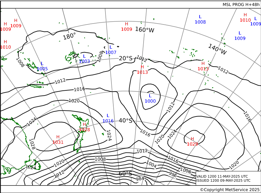
A LOW is expected to form on local Friday near 30S on this trough and deepen
as it travels off to the southeast.
Subtropical ridge (STR)
HIGH 1030 to northeast of NZ is travelling east along 3OS.
HIGH 1034 is expected to form east of Bass Strait by Tuesday and travel east
across central NZ on Thursday.
This is likely to bring a squash zone of enhanced SE winds between NZ and
New Caledonia by Wednesday. Avoid.
Aussie/Tasman/NZ troughs
DEEP LOW 960 near 60 South is travelling east to south of NZ. Associated
cold front is expected to travel over South Island on Monday and North
Island on Tuesday followed by a SIGNIFICANTLY COLD southerly. Avoid
departing from North Island for tropics on Tuesday.
bob@metbob.com
27 June 2021
20 June 2021
Bob blog
Bob McDavitt's ideas for sailing around the South Pacific.
Disclaimer: Weather is a mix of pattern and chaos; these ideas are from the
patterned world.
Compiled Sunday 20 June
The solstice is Monday 21 June at 0331 UTC. When I was learning meteorology
one of my teachers had a saying that covers the next six weeks: "when the
days get longer, the cold gets stronger".
TORNADO: We had one in south Auckland yesterday morning when a vigorous
front passed over Auckland. One person (originally from Fiji) was killed
over 1000 houses damaged and around 60 were rendered uninhabitable. 30 ton
containers were tossed over and a 85ton machine was shunted.
www.stuff.co.nz/environment/300337048/auckland-tornado-carnage-windows-shatt
ered-roofs-destroyed-trees-collapsed
Last week I tried for a second time to share with you links to the y2k
weather maps , but my blog editor again rewrote them, so I won't repeat
them, but you can find them at y2ksail.com/meteo-link.html.
Also worth mentioning are the weather maps from French Polynesia at
pitufa.at/weather-fp/
When underway the surface analysis charts can be downloaded via saildocs
request
send pf.preiso36
send pf.preiso60
WIND ATLAS: And for planning purposes the monthly averaged ocean winds :
.pitufa.at/oceanwinds/ This site has been revamped to work with mobile
devices.
Thanks to Brigit and Christian (from Austria and now on PITUFA in Tahiti)
for their help.
The Tropics
The latest cyclone activity report is at tropic.ssec.wisc.edu and Tropical
Cyclone Potential is from www.ssd.noaa.gov/PS/TROP/TCFP/index.html
DOLORES and CLAUDETTE formed in past few days then faded after going
onshore.
There are moderate zones of potential development off east of Taiwan and
southwest Mexico.
WEATHER ZONES
SPCZ=South Pacific Convergence zone.
The SPCZ is rebuilding and is expected to this week to be from Solomons to
Samoa, somewhat north of its normal position.
A trough over New Caledonia on Monday is expected to travel east and reach
Fiji/Tonga by mid-week and develop a low southeast of Southern Cooks by end
of the week.
Another passing trough is expected to reach New Caledonia by Monday 28 June.
These troughs offer an opportunity for yachts wanting to go east, and a
challenge for those going west.
Subtropical ridge (STR)
HIGH 1030 over Tasmania is expected to travel northeast across the Tasman
Sea and reach the North Island on Thursday then go off to the east.
Next HIGH should be around 1038 over Tasmania by Monday 28 June.
Aussie/Tasman/NZ troughs
Multi-centred LOW with main centre 995 over central North Island is expected
to travel east then southeast.
Another low 1002 is expected to deepen to northeast of Tasmania on Thursday
and travel northeast reaching North Island by Sunday 20 June.
Typical trough/ridge winter pattern with a nearly weekly rhythm.
>>>>>>>>>>>>>>>>>>>>>>>>>>>>>>>>>>>>>>>>>
If you would like more detail for your voyage, then check metbob.com to see
what I offer.
Or Facebook at /www.facebook.com/metbobnz/
Weathergram with graphics is at metbob.wordpress.com (subscribe/unsubscribe
at bottom).
Weathergram archive (with translator) is at weathergram.blogspot.co.nz.
Contact is bob@metbob.com or txt 64277762212
>>>>>>>>>>>>>>>>>>>>>>>>>>>>>>>>>>>>>>>>>>>>>>>>>>>>>>>
13 June 2021
Bob Blog 13 June
Bob McDavitt's ideas for sailing around the South Pacific.
Disclaimer: Weather is a mix of pattern and chaos; these ideas are from the
patterned world.
Compiled Sunday 13 June
First, a reminder that Gulf harbour radio GHR , a coastal radio station
ZMH286, run by Patricia and David, is now operating on 8752kHz or 8779kHz or
8297kHz , in that order depending on interference at (the new COVID time)
0515 UTC (1715 NZST) Monday to Friday. From 7 June they have their live
streaming service running at
www.youtube.com/channel/UCcu-iy7lVF8YiRfXCIBQ28w with a backlist of previous
seasons.
Second, those new links for the Weather Maps that I included in last week's
blog got mangled by my blog editor, so here they are again.
These are courtesy of Max from y2ksail.com, to use anyone of them send an
email to query@saildocs.com, no subject needed, with message SEND and then
the link of your choice:
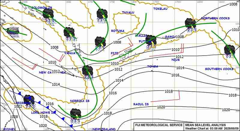
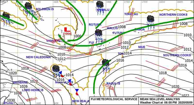
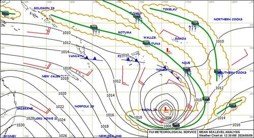
Weather Map coming from Fiji Met Service:
--> 3AM FST Surface Map available daily from 05.00am Fiji time
---> https://www.y2ksail.com/imagesfijimet/3AM-small.jpg
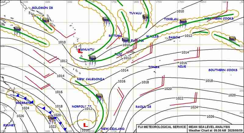
--> 6AM FST Surface Map available daily from 09.30am Fiji time
---> https://www.y2ksail.com/imagesfijimet/6AM-small.jpg
--> 09AM FST Surface Map available daily from 11.00am Fiji time
---> https://www.y2ksail.com/imagesfijimet/9AM-small.jpg
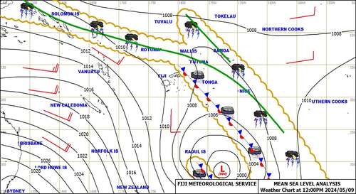
--> 12PM FST Surface Map available daily from 03.00pm Fiji time
---> https://www.y2ksail.com/imagesfijimet/12PM-small.jpg
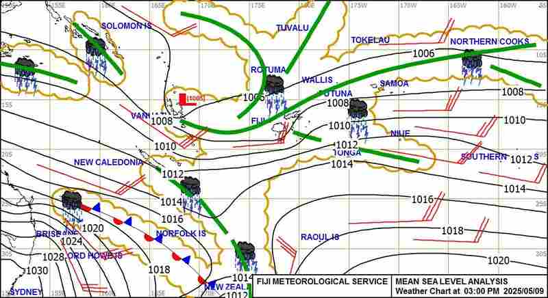
--> 03PM FST Surface Map available daily from 05.00pm Fiji time
---> https://www.y2ksail.com/imagesfijimet/3PM-small.jpg
--> 06PM FST Surface Map available daily from 08.30pm Fiji time
---> https://www.y2ksail.com/imagesfijimet/6PM-small.jpg
--> 12AM FST Surface Map available daily from 03.00am Fiji time
---> https://www.y2ksail.com/imagesfijimet/12AM-small.jpg
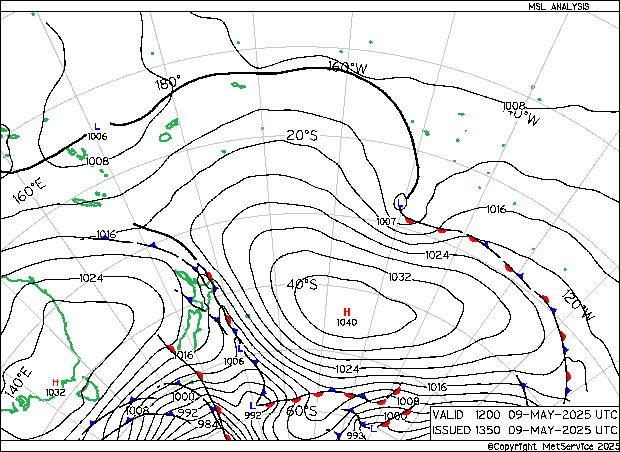
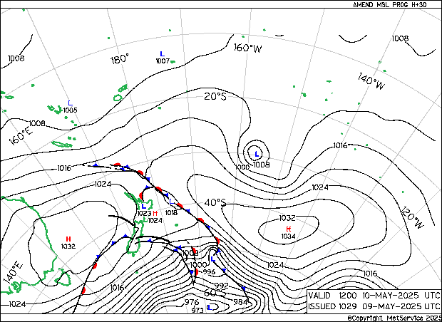
Weather Map from New Zealand Met Service update every 6 hours, normally at
02-08-14-20 UTC TIME:
--> Last Analysis Pressure chart Actual time
---> https://www.y2ksail.com/imagesnzmet/actual.gif
--> +30 hours pressure forecast chart
---> https://www.y2ksail.com/imagesnzmet/h30.gif
--> +48 hours pressure forecast chart
---> https://www.y2ksail.com/imagesnzmet/h48.gif
--> +72 hours pressure forecast chart
---> https://www.y2ksail.com/imagesnzmet/h72.gif
Thirdly, that LOW last week over Victoria, Australia, which brought
wide-spread damage from wind and rain was a polar blast, with cold air being
shoveled into the back of the LOW thanks to a HIGH well south of the
Australian Bight:
The Tropics
The latest cyclone activity report is at tropic.ssec.wisc.edu and Tropical
Cyclone Potential is from www.ssd.noaa.gov/PS/TROP/TCFP/index.html
Storm KOGUMA wakened when it made land fall in Vietnam today. TC CARLOS has
formed (today) in the East North Pacific. There is still a moderate zone of
potential development off the southwest of Mexico.
WEATHER ZONES
SPCZ=South Pacific Convergence zone.
The SPCZ is expected to be rather thin and weak, stretching from Solomon
Islands across Coral Sea to Samoa.
A trough over New Caledonia on Monday is expected to travel west and reach
Fiji/Tonga by mid-week and Southern Cooks by end of the week.
Another passing trough is expected to reach New Caledonia by end of the
week.
These troughs offer an opportunity for yachts wanting to go east, and a
challenge for those going west.
Subtropical ridge (STR)
HIGH 1030 east of NZ is travelling east along 35S. It has a squash zone of
enhanced trade winds on its northern side that will also travel east.
HIGH 1020 is expected to form in the northern Tasman Sea by Wednesday and
travel east past the north of North Island by Saturday.
Another HIGH 1020 is expected to travel northeast out of the Southern Ocean
from Monday and get southeast of South Island by Friday, feeding chilly air
onto South Island on Tuesday and Wednesday.
Aussie/Tasman/NZ troughs
LOW 1004 tonight to east of Tasmania is expected to travel east across the
South Island on Monday/Tuesday
Another low 1002 is expected to deepen to northeast of Tasmania on Thursday
and travel northeast reaching North Island by Sunday 20 June.
Typical trough/ridge inter pattern with a nearly weekly rhythm.
>>>>>>>>>>>>>>>>>>>>>>>>>>>>>>>>>>>>>>>>>
If you would like more detail for your voyage, then check metbob.com to see
what I offer.
Or Facebook at /www.facebook.com/metbobnz/
Weathergram with graphics is at metbob.wordpress.com (subscribe/unsubscribe
at bottom).
Weathergram archive (with translator) is at weathergram.blogspot.co.nz.
Contact is bob@metbob.com or txt 64277762212
>>>>>>>>>>>>>>>>>>>>>>>>>>>>>>>>>>>>>>>>>>>>>>>>>>>>>>>
Disclaimer: Weather is a mix of pattern and chaos; these ideas are from the
patterned world.
Compiled Sunday 13 June
First, a reminder that Gulf harbour radio GHR , a coastal radio station
ZMH286, run by Patricia and David, is now operating on 8752kHz or 8779kHz or
8297kHz , in that order depending on interference at (the new COVID time)
0515 UTC (1715 NZST) Monday to Friday. From 7 June they have their live
streaming service running at
www.youtube.com/channel/UCcu-iy7lVF8YiRfXCIBQ28w with a backlist of previous
seasons.
Second, those new links for the Weather Maps that I included in last week's
blog got mangled by my blog editor, so here they are again.
These are courtesy of Max from y2ksail.com, to use anyone of them send an
email to query@saildocs.com, no subject needed, with message SEND and then
the link of your choice:
Weather Map coming from Fiji Met Service:
--> 3AM FST Surface Map available daily from 05.00am Fiji time
---> https://www.y2ksail.com/imagesfijimet/3AM-small.jpg
--> 6AM FST Surface Map available daily from 09.30am Fiji time
---> https://www.y2ksail.com/imagesfijimet/6AM-small.jpg
--> 09AM FST Surface Map available daily from 11.00am Fiji time
---> https://www.y2ksail.com/imagesfijimet/9AM-small.jpg
--> 12PM FST Surface Map available daily from 03.00pm Fiji time
---> https://www.y2ksail.com/imagesfijimet/12PM-small.jpg
--> 03PM FST Surface Map available daily from 05.00pm Fiji time
---> https://www.y2ksail.com/imagesfijimet/3PM-small.jpg
--> 06PM FST Surface Map available daily from 08.30pm Fiji time
---> https://www.y2ksail.com/imagesfijimet/6PM-small.jpg
--> 12AM FST Surface Map available daily from 03.00am Fiji time
---> https://www.y2ksail.com/imagesfijimet/12AM-small.jpg
Weather Map from New Zealand Met Service update every 6 hours, normally at
02-08-14-20 UTC TIME:
--> Last Analysis Pressure chart Actual time
---> https://www.y2ksail.com/imagesnzmet/actual.gif
--> +30 hours pressure forecast chart
---> https://www.y2ksail.com/imagesnzmet/h30.gif
--> +48 hours pressure forecast chart
---> https://www.y2ksail.com/imagesnzmet/h48.gif
--> +72 hours pressure forecast chart
---> https://www.y2ksail.com/imagesnzmet/h72.gif
Thirdly, that LOW last week over Victoria, Australia, which brought
wide-spread damage from wind and rain was a polar blast, with cold air being
shoveled into the back of the LOW thanks to a HIGH well south of the
Australian Bight:
The Tropics
The latest cyclone activity report is at tropic.ssec.wisc.edu and Tropical
Cyclone Potential is from www.ssd.noaa.gov/PS/TROP/TCFP/index.html
Storm KOGUMA wakened when it made land fall in Vietnam today. TC CARLOS has
formed (today) in the East North Pacific. There is still a moderate zone of
potential development off the southwest of Mexico.
WEATHER ZONES
SPCZ=South Pacific Convergence zone.
The SPCZ is expected to be rather thin and weak, stretching from Solomon
Islands across Coral Sea to Samoa.
A trough over New Caledonia on Monday is expected to travel west and reach
Fiji/Tonga by mid-week and Southern Cooks by end of the week.
Another passing trough is expected to reach New Caledonia by end of the
week.
These troughs offer an opportunity for yachts wanting to go east, and a
challenge for those going west.
Subtropical ridge (STR)
HIGH 1030 east of NZ is travelling east along 35S. It has a squash zone of
enhanced trade winds on its northern side that will also travel east.
HIGH 1020 is expected to form in the northern Tasman Sea by Wednesday and
travel east past the north of North Island by Saturday.
Another HIGH 1020 is expected to travel northeast out of the Southern Ocean
from Monday and get southeast of South Island by Friday, feeding chilly air
onto South Island on Tuesday and Wednesday.
Aussie/Tasman/NZ troughs
LOW 1004 tonight to east of Tasmania is expected to travel east across the
South Island on Monday/Tuesday
Another low 1002 is expected to deepen to northeast of Tasmania on Thursday
and travel northeast reaching North Island by Sunday 20 June.
Typical trough/ridge inter pattern with a nearly weekly rhythm.
>>>>>>>>>>>>>>>>>>>>>>>>>>>>>>>>>>>>>>>>>
If you would like more detail for your voyage, then check metbob.com to see
what I offer.
Or Facebook at /www.facebook.com/metbobnz/
Weathergram with graphics is at metbob.wordpress.com (subscribe/unsubscribe
at bottom).
Weathergram archive (with translator) is at weathergram.blogspot.co.nz.
Contact is bob@metbob.com or txt 64277762212
>>>>>>>>>>>>>>>>>>>>>>>>>>>>>>>>>>>>>>>>>>>>>>>>>>>>>>>
06 June 2021
Bob Blog 6 June 2021
Bob McDavitt's ideas for sailing around the South Pacific.
Disclaimer: Weather is a mix of pattern and chaos; these ideas are from the
patterned world.
Compiled Sunday 6 June
First some great news.
Max of y2ksail.com has fixed the links to weather map images that are small
enough to be able to be accessed when you are at sea by sending emails to
query@sailmail.com even if you are using winlink on a UHF radio.
Weather Map coming from Fiji Met Service:
--> 3AM FST Surface Map available daily from 05.00am Fiji time
---> https://www.y2ksail.com/imagesfijimet/3AM-small.jpg
--> 6AM FST Surface Map available daily from 09.30am Fiji time
---> https://www.y2ksail.com/imagesfijimet/6AM-small.jpg
--> 09AM FST Surface Map available daily from 11.00am Fiji time
---> https://www.y2ksail.com/imagesfijimet/9AM-small.jpg
--> 12PM FST Surface Map available daily from 03.00pm Fiji time
---> https://www.y2ksail.com/imagesfijimet/12PM-small.jpg
--> 03PM FST Surface Map available daily from 05.00pm Fiji time
---> https://www.y2ksail.com/imagesfijimet/3PM-small.jpg
--> 06PM FST Surface Map available daily from 08.30pm Fiji time
---> https://www.y2ksail.com/imagesfijimet/6PM-small.jpg
--> 12AM FST Surface Map available daily from 03.00am Fiji time
---> https://www.y2ksail.com/imagesfijimet/12AM-small.jpg
Weather Map from New Zealand Met Service update every 6 hours, normally at
02-08-14-20 UTC TIME:
--> Last Analysis Pressure chart Actual time
---> https://www.y2ksail.com/imagesnzmet/actual.gif
--> +30 hours pressure forecast chart
---> https://www.y2ksail.com/imagesnzmet/h30.gif
--> +48 hours pressure forecast chart
---> https://www.y2ksail.com/imagesnzmet/h48.gif
--> +72 hours pressure forecast chart
---> https://www.y2ksail.com/imagesnzmet/h72.gif
REVIEW OF THE LAST MONTH (May 2021)
Sea Surface temperature anomalies from
www.weatherzone.com.au/climate/indicator_sst.jsp?lt=global&lc=global&c=ssta
The only highlight of note is a warm blob in the 40 latitudes in the
Northeast Pacific. La Nina has gone, and eastern equatorial Pacific is now
near normal.
To see how the annual weather cycle and the seasons are working out, we can
check the average isobar maps for past 30 days and their anomaly from
psl.noaa.gov/map/clim/glbcir.quick.shtml
The subtropical ridges in both hemispheres have shifted north. It has
intensified in the southern hemisphere and in North Pacific and North
Atlantic but weakened over interior of Europe (as per normal). The north
Indian low has got below 1010. the Indian monsoon has started in the past
few days and is a few days late. The Antarctic High has intensified to over
1030.
A belt of high pressure has shifted from East Eurasia /North Pacific to
cover north America. And across the north Atlantic towards Spain. A High/Lo
couplet in the southeast Pacific has drifted westwards, bringing more
easterly winds than normal to NZ.
Zooming into the NZ area
The subtropical ridge has sifted north as shown by the 1015 isobar. An
interesting trough has formed in the Southern Ocean near 120. The
intensification of the Antarctica high is probably due to the dark cold of
winter.
The Tropics
The latest cyclone activity report is at tropic.ssec.wisc.edu and Tropical
Cyclone Potential is from www.ssd.noaa.gov/PS/TROP/TCFP/index.html
In the past week TC BLANCA briefly formed off west of Mexico. There is still
a moderate zone of potential development there, and a weak zone east of
Philippines and in China sea.
WEATHER ZONES
SPCZ=South Pacific Convergence zone.
The SPCZ is expected to be rather thin and weak, stretching from Solomon
Islands across Coral Sea to Samoa.
A passing trough is expected over Southern Cooks to French Polynesia next
few days.
Another passing trough is expected over Tonga on local Tuesday reaching
Southern Cooks by end of the week. and southern Cooks by end of the week.
Subtropical ridge (STR)
HIGH over 1030 east of the South Island is lingering near 45S 170W until
mid-week then travelling north to 30S and fading, and likely to be joined by
another High near 45S by mid-week, then the combo travels off to the east
along 40S.
No highs in the Tasman Sea this week. A good week for getting from Australia
to Fiji.
Aussie/Tasman/NZ troughs
LOW has formed just north of Northland and is expected to linger there until
mid-week.
Another low is expected to deepen offshore of Sydney by mid-week and move
across central Tasman and reach central NZ early next week.
Another low is expected to form near 25S by end of the week in the passing
trough over Southern Cooks.
Panama to Galapagos/Marquesas
Winds in Panama are expected to turn southerly this week, and the ITCZ is
likely to visit. West to SW winds between Panama and Galapagos, with and
east-going current. It's the end of the season for sailing into the Pacific.
>>>>>>>>>>>>>>>>>>>>>>>>>>>>>>>>>>>>>>>>>
If you would like more detail for your voyage, then check metbob.com to see
what I offer.
Or Facebook at /www.facebook.com/metbobnz/
Weathergram with graphics is at metbob.wordpress.com (subscribe/unsubscribe
at bottom).
Weathergram archive (with translator) is at weathergram.blogspot.co.nz.
Contact is bob@metbob.com or txt 64277762212
>>>>>>>>>>>>>>>>>>>>>>>>>>>>>>>>>>>>>>>>>>>>>>>>>>>>>>>
Subscribe to:
Posts (Atom)