WEATHERGRAM
YOTREPS
Compiled Sun 26 February 2017
Bob McDavitt's ideas for sailing around the South Pacific.
Disclaimer: Weather is a mix of pattern and chaos; these ideas are from the
patterned world.
FEBRUARY
During the middle of Feb 2017, we had an MJO episode cross the South Pacific
triggering EIGHT tropical depressions, of which only one reached (BART) Topical
cyclone - and then only for a day as it left the tropics. The season so far, is
seen at en.wikipedia.org/wiki/2016%E2%80%9317_South_Pacific_cyclone_season
BART was a late starter for the Cyclone Season. It was identified at around
00UTC on Tue 21 Feb 2017 - that's six hours later than TC OMA named at 1800UTC
on 20 Feb 2001--- however the actual start of the cyclone phase, with a little
hand-waving , can easily cover a plus or minus of six hours , so let's just say
we had a late start to our cyclone season this year. See my previous blog
metbob.wordpress.com/2017/02/22/tc-bart-marks-a-late-20162017-cyclone-season-sta
rt/
The MJO has gone now and its next episode in the South pacific may not be until
mid to late March. This should lessen (but NOT dismiss completely) the chance of
tropical depressions in our region over the next few weeks.
Subtropical ridge dominated the South Atlantic and South Indian Ocean, and moved
south onto central NZ but was weak over central South Pacific.
North Pacific still has that "face" with a nose/forehead and two eyes. And
North America is exceedingly troughy/stormy.
Average isobars for last 30 days and their anomaly covering last two months are
at
www.esrl.noaa.gov/psd/map/images/fnl/slp_30b.fnl.html
February rain has mainly been along the South Pacific Convergence zone (those 8
depressions). Two points to note: the Intertropical convergence zone across
the Pacific is much drier than normal. And the "mirror convergence zone "that
occurs every year in early to mid-March between Galapagos and Marquesas (when
sun is directly overhead 5S), has appeared EARLY this year .
Last 30 days of rainfall, and its anomaly, are at
trmm.gsfc.nasa.gov/trmm_rain/Events/thirty_day.html
The tropics
No cyclones or tropical depressions anywhere at this stage.
Now that the MJO has gone and the tropical depressions are moving out of the
tropics, things have settled across the South Pacific. The west/northwest winds
of the monsoon that were around earlier this month have been replaced by SE
trade winds bringing in cooler air from the south. It's now OK to do some
Island hopping for a week or two.
Rain from last week at
trmm.gsfc.nasa.gov/trmm_rain/Events/big_global_accumlation.gif, compared with
previous week, shows a gradual decrease in activity over the South pacific. And
a gradual return to normal along the Intertropical Cyclone convergence zone.
WEATHER ZONES
SPCZ=South Pacific Convergence zone.
SPCZ is weakening and should remain weak over next fortnight.
See the Tropical accumulated rainfall for next week from windyty.com
Subtropical ridge (STR)
HIGH crossing the Tasman sea along 42S is expected to cross central NZ then
Northern NZ from Monday to Friday this week--- a good week to go motoring around
NZ.
Tasman Sea troughs.
Next front is expected to reach southern NZ on Fri 3 March and then travel NE
along east coast on the sat/sun 4/5 March weekend, followed by another HIGH.
A coastal trough off eastern seaboard of Australia is likely to bring rain and
fresh onshore winds, getting strong around Sydney by end of the week.
NEW: Panama to Galapagos
Looks good for departure by 5 March in northerly winds. Then not so good for
the following week or so in light winds or southerly winds. Prepare for light
head winds near Galapagos
NEW: Galapagos to Marquesas
Expect only light winds until the convergence zone near 5S, then squally showers
to around 10S then OK in ESE to E 10 knots to Marquesas.
>>>>>>>>>>>>>>>>>>>>>>>>>>>>>>>>>>>>>>>>>>>>>>>>>>>>>>>>
Follow me on Facebook at www.facebook.com/metbobnz/
See my yotpak at boatbooks.co.nz/weather.html for terms used.
See my website www.metbob.com for information on tailor-made voyage forecasts-
Feedback to bob@metbob.com.
Tell anyone you like that to subscribe they should email me.
Weathergram text only (and translator) is at weathergram.blogspot.co.nz.
Weathergram with graphics is at metbob.wordpress.com,
Click FOLLOW at bottom right to subscribe.
To unsubscribe from WordPress: click the "unsubscribe" link on the bottom of the
email. Or, if email wasn't from WordPress then send a reply email saying LEAVE.
>>>>>>>>>>>>>>>>>>>>>>>>>>>>>>>>>>>>>>>>>>>>>>>>>>
26 February 2017
22 February 2017
TC BART marks a late 2016/2017 Cyclone season start
TC BART marks a late 2016/2017 Cyclone season start
TC BART is now affecting parts of the far south of the Southern Cooks
as seen at Fiji Threat map at www.met.gov.fj/aifs_prods/65660.gif
NASA shows it first having a cyclone signature at around 00UTC on Tue 21 Feb
2017.
see phys.org/news/2017-02-nasa-south-pacific-tropical-cyclone.html
This makes for a LATE starting season, beating the record* held by TC OMA
- named at 1800UTC on 20 Feb 2001,
by a mere 6 hours.
(Thanks to my friend Steve Ready for this information).
That's really too close to call as far as meteorology goes. And with a little
hand-waving the start of the cyclone phase of either OMA or BART could be plus
or minus 6 hours. SO let's just say it's a late start to the cyclone season.
Even so, we live in interesting times. SO far we have had 15 Tropical
depressions this season (that's more than normal), and only ONE has managed to
became a cyclone.
* the "late starting season" record is a concept of modern times, and really
only has meaning since satellite imagery become commonplace in the 1970s.
Bob McDavitt
19 February 2017
Bob Blog 19 Feb 2017
WEATHERGRAM
YOTREPS
Compiled Sun 19 February 2017
Bob McDavitt's ideas for sailing around the South Pacific.
Disclaimer: Weather is a mix of pattern and chaos; these ideas are from the
patterned world.
A new weather viewer has been brought to my attention and I'd like to share it
with you all at www.ventusky.com/ It has good animation graphics, but at
present is limited to the weaker models GEM and GFS.
The Atmosphere: The Southern Oscillation Index SOI (30 day running mean) sums up
the weather pattern over the South Pacific as one number. It is based on the
standardized difference in the barometer readings between Tahiti and Darwin. A
La Nina event occurs when the SOI is more than plus one (standard deviation from
its mean) for more than a month. Recently the SOI has been relaxing to near
zero.
SOI as seen
www.farmonlineweather.com.au/climate/indicator_enso.jsp?c=soi&p=weekly
The Ocean: The eastern equatorial Pacific Ocean can sometimes act as a storage
area for extra heat. Those periods are called El Nino and we had an extreme
example of one of these last year, as measured by the NINO3.4 index. In the
past couple of months the NINO3.4 was a mild negative, hinting to the
possibility of a weak La Nina. However it is now relaxing to near zero.
Ocean Heat index NINO3.4 is showing a relaxing trend as seen at
www.farmonlineweather.com.au/climate/indicator_enso.jsp?c=nino34&p=weekly
The tropics
The MJO that visited the South Pacific Ocean last week has triggered THREE
tropical depressions. None of these managed to find the correct upper air
conditions to deepen into a tropical cyclone (not yet anyway, too windy aloft)
and that is perhaps a blessing.
Tropical depressions: TD90 (near French Polynesia) , 91 (in Gulf of
Carpentaria) and 92 (South of Fiji) as seen at ruc.noaa.gov/tracks/
However, Tropical cyclones are the current "safety valves" that allow our
atmosphere to "let off steam" when it has stored to much energy. If they fail,
then it begs the question, "What's next?" For a media investigation into this
read
www.abc.net.au/news/2017-02-10/rains-across-south-pacific-continues-amid-floodin
g/8260920 with help from Neville Koop of Ndraki weather
Activity in the tropics is strongest around TD 90. 91 and 92. And the ITCZ has
almost disappeared across the North Pacific! Also, note the interesting
convergence zone that has formed just south of Marquesas. That is something of
a concern, and we hope it disappears before the panama to Marquesas puddle
jumpers get going over next few weeks.
Rain for the past fortnight from
trmm.gsfc.nasa.gov/trmm_rain/Events/big_global_accumlation.gif
WEATHER ZONES
Weather Zones (see text) as expected mid-week on Wednesday (GFS model) showing
wind, isobars, current, swell black arrows / Sig wave height purple lines, SPCZ
and STR.
SPCZ=South Pacific Convergence zone.
SPCZ is active at present with three tropical depressions, but the MJO has moved
on and things are expected to weaken gradually during this week. TD 90, 91 and
92 may deepen as they move off but not for long. As mentioned before, that
convergence zone between Galapagos and Marquesas is abnormal and of concern.
Tropical accumulated rainfall for next week from windyty.com
Subtropical ridge (STR)
Wow, a Big Fat High (BFH), over 1038hPa has become stationary near 50S 170W
today. This week it should slowly weaken and only finally go NE on Thursday and
be replaced by a 1024 high near 40S 170W by end of the week.
Per one of my sayings: "If the High is over 1030 then it's going to get dirty".
In this case, we can expect a squash zone of enhanced easterly winds between the
High and that tropical depression to the north, and this zone of enhanced winds
should bring a period of moderate easterly swell on to east coast of Northern NZ
this week. So, avoid travel east of NZ now to Thursday.
The good news is that swell fades away by Sat 25 Feb for CANANZ SUMMER CRUISE
to Mahurangi, see
cananz.files.wordpress.com/2015/12/cananz_newsletterjanuary2017.pdf
Replacement High is expected to travel into central Tasman sea on Wednesday and
across central NZ on weekend 25/26 Feb.
Tasman Sea/NZ Area troughs.
There's a big low in South Tasman Sea tonight, and it's going off to the
southsoutheast. Associated tough-a gap between Highs-is expected to cross
central NZ around Thursday 23 Feb. Nothing much to avoid near northern NZ except
for an easterly swell until Wednesday.
>>>>>>>>>>>>>>>>>>>>>>>>>>>>>>>>>>>>>>>>>>>>>>>>>>>>>>>>
Follow me on Facebook at www.facebook.com/metbobnz/
See my yotpak at boatbooks.co.nz/weather.html for terms used.
See my website www.metbob.com for information on tailor-made voyage forecasts-
Feedback to bob@metbob.com.
Tell anyone you like that to subscribe they should email me.
Weathergram text only (and translator) is at weathergram.blogspot.co.nz.
Weathergram with graphics is at metbob.wordpress.com,
Click FOLLOW at bottom right to subscribe.
To unsubscribe from WordPress: click the "unsubscribe" link on the bottom of the
email. Or, if email wasn't from WordPress then send a reply email saying LEAVE.
12 February 2017
Bob Blog 12 Feb 2017
WEATHERGRAM
YOTREPS
Compiled Sun 12 February 2017
Bob McDavitt's ideas for sailing around the South Pacific.
Disclaimer: Weather is a mix of pattern and chaos; these ideas are from the
patterned world.
Lisa Blair has now crossed the dateline in her Around Antarctic adventure.
See lisablairsailstheworld.com/blog/2017/2/11/time-travel-i-am-now-in-yesterday
Her campaign still needs funding so if you would like to make a small donation
to help then please do so at lisablairsailstheworld.com
The tropics
A MJO (Madden Julian Oscillation) of increased convection is moving into the
South Pacific last week and this week. Two large and very active tropical
depressions TD 10F and TD 11F have been the result, near New Caledonia and Fiji,
and they are now weakening. The South Pacific convergence zone now has mostly NW
winds on its northern side as seen at windyty.com
There is a distict lack of trade wind southeasterlies. I think one of the
factors why these depressions did not deepen into tropical cyclones was to do
with stronger winds aloft, so that they had their tops knocked off.
Nevertheless, they have been wet enough to flood rivers in Fiji (Nadi, Lautoka,
Rakiraki and Tavua). Queens road flooded near Nadi, see
www.radionz.co.nz/international/pacific-news/323624/warning-to-stay-off-roads-as
-heavy-rain-causes-flooding-in-fiji
Meanwhile there has been a heat wave over eastern Australia: Sydney airport,
near the sea, breaching 40C over past two days, and Penrith, a few miles inland,
breaching 45C. Should return to normal temperatures over next few days in a S/SW
change. The February graphs can be seen on Weather Underground at
tinyurl.com/h8d9tfs and tinyurl.com/zjodfm8
And in the Indian Ocean TC CARLOS is finally weakening after travelling mostly
southwards to east of Madagascar.
Activity in the tropics is increasing over N of Australia, and across the South
Pacific, and remains weak elsewhere.
Rain for the past fortnight may be seen at
trmm.gsfc.nasa.gov/trmm_rain/Events/big_global_accumlation.gif
WEATHER ZONES
SPCZ=South Pacific Convergence zone.
SPCZ is showing signs of increasing intensity over Coral Sea/New
Caledonia/Vanuatu area and another branch from Samoa to Southern Cooks.
Depressions are likely near New Caledonia /Vanuatu and Southern Cooks and in
Coral Sea by mid-week. Any of these depressions has the risk of deepening into
a tropical cyclone, and the one near New Caledonia is the most likely.
Subtropical ridge (STR)
The High north of NZ tonight is travelling east along 25 to 30S.
Next HIGH is expected to travel east along 40S into central Tasman Sea by
Wednesday then to east of South Island leaving a cell to west of central NZ on
Wed to Saturday.
This High may linger to east of NZ all next week as well, maintaining an
easterly flow onto northern NZ.
Tasman Sea/NZ Area troughs.
Low is deepening tonight and Monday to east of Canterbury but should quickly
travel SE away from NZ and towards Lisa Blair. Another trough is likely to cross
NZ on Tuesday.
Then, a High is expected to linger over central NZ for a week or so.
Mind you, this does mean that northern NZ is likely to get easterly wind sea and
swell for a week or so.
>>>>>>>>>>>>>>>>>>>>>>>>>>>>>>>>>>>>>>>>>>>>>>>>>>>>>>>>
Follow me on Facebook at www.facebook.com/metbobnz/
See my yotpak at boatbooks.co.nz/weather.html for terms used.
See my website www.metbob.com for information on tailor-made voyage forecasts
- Feedback to bob@metbob.com.
Tell anyone you like that to subscribe they should email me.
Weathergram text only (and translator) is at weathergram.blogspot.co.nz.
Weathergram with graphics is at metbob.wordpress.com,
Click FOLLOW at bottom right to subscribe.
To unsubscribe send a reply email saying LEAVE.
>>>>>>>>>>>>>>>>>>>>>>>>>>>>>>>>>>>>>>>>>>>>>>>>>>>>>>>>>>>>
YOTREPS
Compiled Sun 12 February 2017
Bob McDavitt's ideas for sailing around the South Pacific.
Disclaimer: Weather is a mix of pattern and chaos; these ideas are from the
patterned world.
Lisa Blair has now crossed the dateline in her Around Antarctic adventure.
See lisablairsailstheworld.com/blog/2017/2/11/time-travel-i-am-now-in-yesterday
Her campaign still needs funding so if you would like to make a small donation
to help then please do so at lisablairsailstheworld.com
The tropics
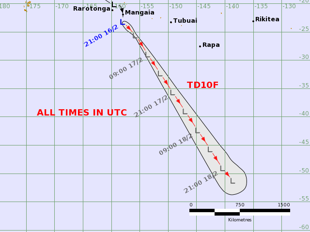
A MJO (Madden Julian Oscillation) of increased convection is moving into the
South Pacific last week and this week. Two large and very active tropical
depressions TD 10F and TD 11F have been the result, near New Caledonia and Fiji,
and they are now weakening. The South Pacific convergence zone now has mostly NW
winds on its northern side as seen at windyty.com
There is a distict lack of trade wind southeasterlies. I think one of the
factors why these depressions did not deepen into tropical cyclones was to do
with stronger winds aloft, so that they had their tops knocked off.
Nevertheless, they have been wet enough to flood rivers in Fiji (Nadi, Lautoka,
Rakiraki and Tavua). Queens road flooded near Nadi, see
www.radionz.co.nz/international/pacific-news/323624/warning-to-stay-off-roads-as
-heavy-rain-causes-flooding-in-fiji
Meanwhile there has been a heat wave over eastern Australia: Sydney airport,
near the sea, breaching 40C over past two days, and Penrith, a few miles inland,
breaching 45C. Should return to normal temperatures over next few days in a S/SW
change. The February graphs can be seen on Weather Underground at
tinyurl.com/h8d9tfs and tinyurl.com/zjodfm8
And in the Indian Ocean TC CARLOS is finally weakening after travelling mostly
southwards to east of Madagascar.
Activity in the tropics is increasing over N of Australia, and across the South
Pacific, and remains weak elsewhere.
Rain for the past fortnight may be seen at
trmm.gsfc.nasa.gov/trmm_rain/Events/big_global_accumlation.gif
WEATHER ZONES
SPCZ=South Pacific Convergence zone.
SPCZ is showing signs of increasing intensity over Coral Sea/New
Caledonia/Vanuatu area and another branch from Samoa to Southern Cooks.
Depressions are likely near New Caledonia /Vanuatu and Southern Cooks and in
Coral Sea by mid-week. Any of these depressions has the risk of deepening into
a tropical cyclone, and the one near New Caledonia is the most likely.
Subtropical ridge (STR)
The High north of NZ tonight is travelling east along 25 to 30S.
Next HIGH is expected to travel east along 40S into central Tasman Sea by
Wednesday then to east of South Island leaving a cell to west of central NZ on
Wed to Saturday.
This High may linger to east of NZ all next week as well, maintaining an
easterly flow onto northern NZ.
Tasman Sea/NZ Area troughs.
Low is deepening tonight and Monday to east of Canterbury but should quickly
travel SE away from NZ and towards Lisa Blair. Another trough is likely to cross
NZ on Tuesday.
Then, a High is expected to linger over central NZ for a week or so.
Mind you, this does mean that northern NZ is likely to get easterly wind sea and
swell for a week or so.
>>>>>>>>>>>>>>>>>>>>>>>>>>>>>>>>>>>>>>>>>>>>>>>>>>>>>>>>
Follow me on Facebook at www.facebook.com/metbobnz/
See my yotpak at boatbooks.co.nz/weather.html for terms used.
See my website www.metbob.com for information on tailor-made voyage forecasts
- Feedback to bob@metbob.com.
Tell anyone you like that to subscribe they should email me.
Weathergram text only (and translator) is at weathergram.blogspot.co.nz.
Weathergram with graphics is at metbob.wordpress.com,
Click FOLLOW at bottom right to subscribe.
To unsubscribe send a reply email saying LEAVE.
>>>>>>>>>>>>>>>>>>>>>>>>>>>>>>>>>>>>>>>>>>>>>>>>>>>>>>>>>>>>
05 February 2017
Bob Blog 5 Feb 2017
WEATHERGRAM
YOTREPS
Compiled Sun 05 February 2017
Bob McDavitt's ideas for sailing around the South Pacific.
Disclaimer: Weather is a mix of pattern and chaos; these ideas are from the
patterned world.
During Jan 2017, the Subtropical ridge moved south in the Indian Ocean and
slight south in the South Pacific as compared to its December position, but also
weakened a bit in the Tasman Sea area. The anomaly maps for January around the
Tasman Sea are much the same as in December-and that explains the continuation
of the strong westerly flow over southern New Zealand. Over Indian
Ocean/Western Australia the trend id for an easing and easterly travel in the
troughiness.
Average isobars for 30 days and their anomalies may be seen at
www.esrl.noaa.gov/psd/map/images/fnl/slp_30b.fnl.html
There is now a strange "face-like figure' in the Northern Pacific, with
something strange happening over California.
January rain has been less than normal over the Indian ocean equator, The South
Pacific Convergence zone and the ITCZ. This is consistent with the late start
in the South pacific cyclone season.
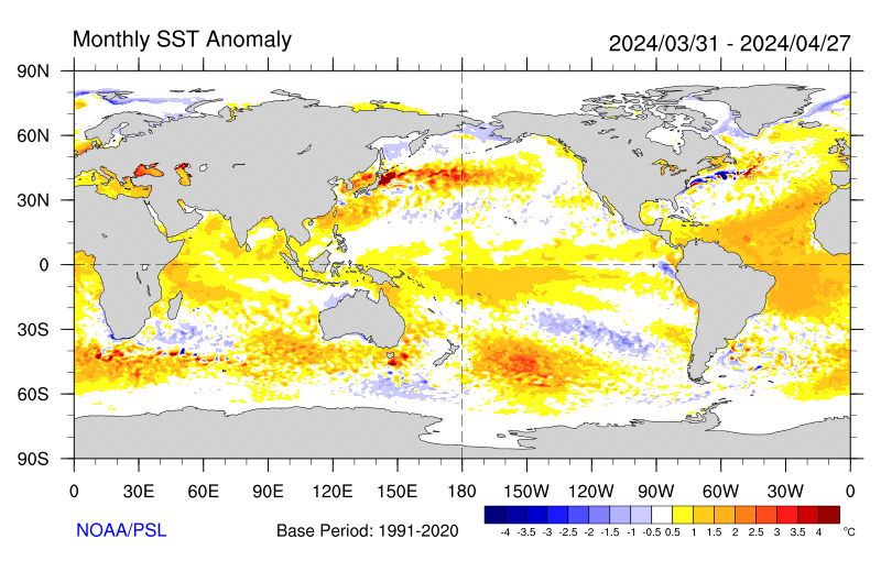
There is a rough link between the rain anomalies and the Sea surface temperature
anomalies (except around western South Island of New Zealand). Sea surface
temperature anomalies suggest that the Fiji to Southern Cooks area may be at
increased risk of cyclogenesis during (mid to late) February.
as seen at www.esrl.noaa.gov/psd/map/images/sst/sst.anom.month.gif
Tropics.
A Madden Julian Oscillation of increased convection is now being forecast to
strengthen this week and travel east across Australia and into the Western
Pacific later this month, building convective activity.
This is already producing some near -equatorial NW to Northerly wind burst over
NW Australia and in the South Pacific, as shown in tonight's windyty.com
imagery:
The probability of a tropical cyclone in the Coral Sea between 19 and 25 Feb has
been estimated by Meteo France to be up to 50%, as seen at
www.meteo.nc/nouvelle-caledonie/cyclone/coin-des-experts
In the Indian Ocean TC CARLOS is travelling mostly southwards to east of
Madagascar.
It is a sign that a new MJO is travelling east towards Australia.
Activity in the tropics is increasing to NW of Australia, and is easing to very
quiet along the ITCZ across central Pacific. Rain for the past week is at
trmm.gsfc.nasa.gov/trmm_rain/Events/big_global_accumlation.gif
WEATHER ZONES
SPCZ=South Pacific Convergence zone.
SPCZ is showing signs of increasing intensity over Coral Sea/Fiji/Tonga/Niue and
Southern Cooks. A depression may form in Coral Sea by Wednesday and the weaken.
Tropical accumulated rainfall for next week is at windyty.com
Subtropical ridge (STR)
The High east of North island tonight is travelling off to east along 40S from
Monday/ New Zealand day, followed by a strong NW flow over central NZ on Monday
and then a weakening trough on Tuesday.
New HIGH is expected to travel east of Tasmania into South Tasman Sea on
Wednesday, preceded by a south/Southeast flow over North Island. The High's
isobars should squeeze around Southland on Wednesday and then travel east to
east of South Island along 45S on Thursday.
Another High should cross central Tasman sea on Friday and skirt northern NZ on
Sat/Sun 11/12 Feb.
Tasman Sea/NZ Area troughs.
Trough is expected to cross South Island on Monday and fade over central NZ on
Tuesday.
Next trough is expected to reach SW of NZ on Friday and fade away on Saturday
before reaching central NZ.
SO, rain over NZ this week is less than it has been recently.
Even so, the outlook for next week is for several active fronts.
>>>>>>>>>>>>>>>>>>>>>>>>>>>>>>>>>>>>>>>>>>>>>>>>>>>>>>>>
Follow me on Facebook at www.facebook.com/metbobnz/
See my yotpak at boatbooks.co.nz/weather.html for terms used.
See my website www.metbob.com for information on tailor-made voyage forecasts-
Feedback to bob@metbob.com.
Tell anyone you like that to subscribe they should email me.
Weathergram text only (and translator) is at weathergram.blogspot.co.nz.
Weathergram with graphics is at metbob.wordpress.com,
Click FOLLOW at bottom right to subscribe.
To unsubscribe from WordPress: click the "unsubscribe" link on the bottom of the
email. Or, if email wasn't from WordPress then send a reply email saying LEAVE.
>>>>>>>>>>>>>>>>>>>>>>>>>>>>>>>>>>>>>>>>>>>>>>>>>>>>>>>>>>>>
YOTREPS
Compiled Sun 05 February 2017
Bob McDavitt's ideas for sailing around the South Pacific.
Disclaimer: Weather is a mix of pattern and chaos; these ideas are from the
patterned world.
During Jan 2017, the Subtropical ridge moved south in the Indian Ocean and
slight south in the South Pacific as compared to its December position, but also
weakened a bit in the Tasman Sea area. The anomaly maps for January around the
Tasman Sea are much the same as in December-and that explains the continuation
of the strong westerly flow over southern New Zealand. Over Indian
Ocean/Western Australia the trend id for an easing and easterly travel in the
troughiness.
Average isobars for 30 days and their anomalies may be seen at
www.esrl.noaa.gov/psd/map/images/fnl/slp_30b.fnl.html
There is now a strange "face-like figure' in the Northern Pacific, with
something strange happening over California.
January rain has been less than normal over the Indian ocean equator, The South
Pacific Convergence zone and the ITCZ. This is consistent with the late start
in the South pacific cyclone season.
There is a rough link between the rain anomalies and the Sea surface temperature
anomalies (except around western South Island of New Zealand). Sea surface
temperature anomalies suggest that the Fiji to Southern Cooks area may be at
increased risk of cyclogenesis during (mid to late) February.
as seen at www.esrl.noaa.gov/psd/map/images/sst/sst.anom.month.gif
Tropics.
A Madden Julian Oscillation of increased convection is now being forecast to
strengthen this week and travel east across Australia and into the Western
Pacific later this month, building convective activity.
This is already producing some near -equatorial NW to Northerly wind burst over
NW Australia and in the South Pacific, as shown in tonight's windyty.com
imagery:
The probability of a tropical cyclone in the Coral Sea between 19 and 25 Feb has
been estimated by Meteo France to be up to 50%, as seen at
www.meteo.nc/nouvelle-caledonie/cyclone/coin-des-experts
In the Indian Ocean TC CARLOS is travelling mostly southwards to east of
Madagascar.
It is a sign that a new MJO is travelling east towards Australia.
Activity in the tropics is increasing to NW of Australia, and is easing to very
quiet along the ITCZ across central Pacific. Rain for the past week is at
trmm.gsfc.nasa.gov/trmm_rain/Events/big_global_accumlation.gif
WEATHER ZONES
SPCZ=South Pacific Convergence zone.
SPCZ is showing signs of increasing intensity over Coral Sea/Fiji/Tonga/Niue and
Southern Cooks. A depression may form in Coral Sea by Wednesday and the weaken.
Tropical accumulated rainfall for next week is at windyty.com
Subtropical ridge (STR)
The High east of North island tonight is travelling off to east along 40S from
Monday/ New Zealand day, followed by a strong NW flow over central NZ on Monday
and then a weakening trough on Tuesday.
New HIGH is expected to travel east of Tasmania into South Tasman Sea on
Wednesday, preceded by a south/Southeast flow over North Island. The High's
isobars should squeeze around Southland on Wednesday and then travel east to
east of South Island along 45S on Thursday.
Another High should cross central Tasman sea on Friday and skirt northern NZ on
Sat/Sun 11/12 Feb.
Tasman Sea/NZ Area troughs.
Trough is expected to cross South Island on Monday and fade over central NZ on
Tuesday.
Next trough is expected to reach SW of NZ on Friday and fade away on Saturday
before reaching central NZ.
SO, rain over NZ this week is less than it has been recently.
Even so, the outlook for next week is for several active fronts.
>>>>>>>>>>>>>>>>>>>>>>>>>>>>>>>>>>>>>>>>>>>>>>>>>>>>>>>>
Follow me on Facebook at www.facebook.com/metbobnz/
See my yotpak at boatbooks.co.nz/weather.html for terms used.
See my website www.metbob.com for information on tailor-made voyage forecasts-
Feedback to bob@metbob.com.
Tell anyone you like that to subscribe they should email me.
Weathergram text only (and translator) is at weathergram.blogspot.co.nz.
Weathergram with graphics is at metbob.wordpress.com,
Click FOLLOW at bottom right to subscribe.
To unsubscribe from WordPress: click the "unsubscribe" link on the bottom of the
email. Or, if email wasn't from WordPress then send a reply email saying LEAVE.
>>>>>>>>>>>>>>>>>>>>>>>>>>>>>>>>>>>>>>>>>>>>>>>>>>>>>>>>>>>>
Subscribe to:
Posts (Atom)