WEATHERGRAM
YOTREPS
Compiled Sun 26 March 2017
Bob McDavitt's ideas for sailing around the South Pacific.
Disclaimer: Weather is a mix of pattern and chaos; these ideas are from the patterned world.
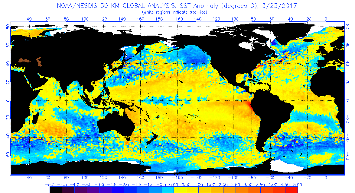
The flooding in Peru is due to the arrival of warm water along its coastline... this can sometimes herald an El Nino episode, but it is occurring in March rather than December.
As seen at www.ospo.noaa.gov/data/sst/anomaly/2017/anomnight.3.23.2017.gif
It is interesting that most of the tropical Pacific now has above normal Sea surface temperature, and there is only a small zone of cooler than normal sea near Kiribati. This cool pool is also likely to be a zone of less-than-normal rainfall.
The Tropics.
TC DEBBIE has formed in te Coral Sea and is expected to reach Cat 4 by the time it makes landfall on Tuesday along the Queensland Coast between Townsville and Bowen. Avoid.
It can be seen at www.tropicaltidbits.com/storminfo/13P_gefs_latest.png
In the Indian Ocean we have TC CALEB near Cocus island at cat 1.
The rain map at trmm.gsfc.nasa.gov/trmm_rain/Events/big_global_accumlation.gif from last week, when compared with previous week, shows continuing heavy rain around Nw and Ne Australia, the Peru coast, the Amazon, and the equatorial Atlantic. The convergence zone between Galapagos and Marquesas is one that tends to occur around this time of the year, and is still larger that the ITCZ that mirrors it in the northern hemisphere.
WEATHER ZONES
SPCZ=South Pacific Convergence zone.
SPCZ has been very active over last few days. A small tropical depression is expected to form east of Samoa on Friday local and travel southeast across Southern cooks this weekend.
The near equatorial "extra convergence zone" is expected to hang around for a few weeks.
Subtropical ridge (STR)
On Monday, the High that is currently east of the South Island is expected to migrate east and expand and reach a peak of 1030 hPa near 40S 158E on Monday.
Then another high should squeeze around southern NZ on Mon/Tue and go NE and peak at 1037hPa near 40S 160W by Thursday.
Tasman Sea troughs.
The Low west of North island tonight I expected to weaken and travel NE on Monday then south across mainland NZ on Tuesday/Wednesday/Thursday. It may bring some thundery showers, so is worth avoiding.
The remains of TC DEBBIE are expected to travel SE across the Tasman Sea on Fri/Sat/Sun, then across the North Island early next week.
Mexico to Marquesas:
The next Tehuantepec NE blast of wind near 95W is expected around 8 April.
Depending upon departure point I think the best northerly wind flow for departure this week is around Wed and Thu local this week, and after that winds may not be so good at the start.
As for waypoints: with NW to N to NE winds to Equator and then weak NE wind south of the equator, aim to take on the ITCZ between 10N 130W and Equator 135W, squalls should fade south of 5N.
Anticipate an extra convergence zone, with light winds and squalls, near 8S on the way to Marquesas.
Panama to Galapagos
Looks good for departure until 29 March with northerly winds for starters. After that winds are lighter and may be southerly. Main convection is likely between 5N and 2N.
Prepare for light winds south of 5N, maybe head for 5N 82W as a waypoint for best wind and tail current.
Galapagos to Marquesas
There is now a river of east going current between 2 and 6S west of Galapagos, hard to avoid. Maybe go to waypoints 10S 100W then 12S 125W then direct. The deviation so far to south is to avoid a counter-current and that extra convergence zone and its squalls.
The pattern is changing and may well be different in a week or so, so get updates, maybe able to cut there corners.
>>>>>>>>>>>>>>>>>>>>>>>>>>>>>>>>>>>>>>>>>>>>>>>>>>>>>>>>
See my website www.metbob.com for more information
Feedback to bob@metbob.com or txt 6427 7762212
Weathergram text only (and translator) is at weathergram.blogspot.co.nz.
Weathergram with graphics is at metbob.wordpress.com, Click FOLLOW at bottom right to subscribe.
To unsubscribe from WordPress: click the "unsubscribe" link on the bottom of the email. Or, if email wasn't from WordPress then send a reply email saying LEAVE.
>>>>>>>>>>>>>>>>>>>>>>>>>>>>>>>>>>>>>>>>>>>>>>>>>>
26 March 2017
19 March 2017
Bob Blog 19 March 2017
WEATHERGRAM
YOTREPS
Compiled Sun 19 March 2017
Bob McDavitt's ideas for sailing around the South Pacific.
Disclaimer: Weather is a mix of pattern and chaos; these ideas are from the patterned world.
The passing a great meteorologist.
Dev Raj Sikka died of a cardiac arrest yesterday (18 March) at the age of 85. He leaves a great legacy, linking the behaviour of the Asian Monsoon to El Nino back in 1982. He has been involved in the preparation of more than 200 scientific papers on meteorology from India, over the last 60 years. He has earned the name "Monsoon Man"
Last December he received the prestigious 'lifetime achievement award' from IMS (the Indian Meteorological Society). And back in 2010 he was the recipient of the Sir Gilbert Walker Gold Medal. (Sir Gilbert Walker was a statistician who applied lag-correlation techniques when appointed as Director-General of the Indian Meteorological Department in 1904 resulting in the Yule-Walker equations and the Southern Oscillation Index).
For more reading: projecteuclid.org/download/pdf_1/euclid.ss/1023799000
The Equinox
The sun is directly over the equator at 10:28UTC on 20 March. This marks a natural "corner" in the orbit of the earth around the sun, and indeed is marked as a turning point in the seasonal weather patterns.
It is interesting that, over the eastern equatorial pacific, the arrival of warmer-than-normal sea along the coast recently has, over the last few days, triggered downpours that are bringing floods and mudslides - the worst in 20 years. This has already been called "El Nino Rain" at www.thestar.com/news/world/2017/03/17/peru-floods-caused-by-el-nino-rain-kill-at-least-67.html
The Tropics.
There are some tropical depressions around and some active convergence zones, but we have gone thru another quiet week as far as tropical cyclones are concerned.
The rain map from last week, when compared with previous week, as seen at trmm.gsfc.nasa.gov/trmm_rain/Events/big_global_accumlation.gif shows continuing heavy rain around northern and eastern Australia and across Peru, the Amazon, and the equatorial Atlantic. The convergence zone between Galapagos and Marquesas is one that tends to occur around this time of the year, and is starting to show signs of weakening.
WEATHER ZONES
SPCZ=South Pacific Convergence zone.
SPCZ has been very active over Fiji for last few days. A small tropical depression is expected to travel along the SPCZ across Tonga on Monday/Tuesday and then off to the SE. After that the SPCZ is expected to drift north and be very active this week across the Coral Sea and the Northern Vanuatu /Wallis and Futuna/and Samoa to Niue area.
The "near equatorial convergence zone" is expected to hang around for a few weeks.
Subtropical ridge (STR)
Much like last week, another "dry High" is in the Tasman Sea tonight and expected to travel across northern North Island from Monday to Thursday. Next HIGH over NZ is expected around 27/28 March.
Tasman Sea troughs.
The Low between two highs is expected in Tasman Sea/NZ area on Fri 24 to Sun 26 March. Avoid.
Mexico to Marquesas:
There is expected to be a Tehuantepec NE blast of wind near 95W until local Wednesday to avoid. The ITCZ is still rather weak and can be expected to bring some squalls between 10N and 5N. There may also be some squalls near 5S. Should be a tail wind to 6N, mostly 10 to 15 knots, then light winds.
Panama to Galapagos
Looks good for departure until 28 March with northerly winds for starters. After that winds are lighter and may be southerly. Main convection is likely between 5N and 2N.
Prepare for light winds south of 4N, maybe head for 4N 83deg30minsW as a waypoint for best wind and tail current.
Galapagos to Marquesas
There is now a river of east-going current between 2 and 6S west of Galapagos, hard to avoid.
Maybe go to waypoints 5S 93W and then 10S 110W then direct. This will get into the trade winds and south of the squalls in the near equatorial convergence zone.
The pattern is changing and may well be different in a week or so, so get updates.
>>>>>>>>>>>>>>>>>>>>>>>>>>>>>>>>>>>>>>>>>>>>>>>>>>>>>>>>
See my website www.metbob.com for more information
Feedback to bob@metbob.com or txt 6427 7762212
Weathergram text only (and translator) is at weathergram.blogspot.co.nz.
Weathergram with graphics is at metbob.wordpress.com, Click FOLLOW at bottom right to subscribe.
To unsubscribe send a reply email saying LEAVE.
>>>>>>>>>>>>>>>>>>>>>>>>>>>>>>>>>>>>>>>>>>>>>>>>>>
12 March 2017
Bob Blog 12 March 2017
WEATHERGRAM
YOTREPS
Compiled Sun 12 March 2017
Bob McDavitt's ideas for sailing around the South Pacific.
Disclaimer: Weather is a mix of pattern and chaos; these ideas are from the patterned world.
The state of the ENSO
The Atmosphere:
The Southern Oscillation Index SOI (30 day running mean) sums up the weather pattern over the South Pacific as one number. It is based on the standardized difference in the barometer readings between Tahiti and Darwin. When the SOI is more than plus one (standard deviation from its mean) for more than a month we call it a LA NINA event, and when it stays more than minus one we call it an EL NINO event.
El Nino and La Nina are tropical influences on the weather: the La Nina shifts the subtropical ridge away from the equator and the El Nino draws the subtropical ridge closer to the equator. This affects the seasonal weather all around the planet.
From May 2015 to May 2016 we had an extreme El Nino. Then there was a weak La Nina in October 2016, and since then we have had only a weak SOI. In the past few weeks it has been near zero and slightly negative.
A weak SOI is seen at www.farmonlineweather.com.au/climate/indicator_enso.jsp?c=soi&p=weekly
The Ocean:
The eastern equatorial Pacific Ocean acts as a heat storage area during an El Nino, or becomes cooler than normal during a La Nina. This plays with the heat budget of the atmosphere and thus with the weather patterns.
There was a period of cooler than normal sea over the past few months, and now things are around normal.
as seen at www.farmonlineweather.com.au/climate/indicator_enso.jsp?c=nino34&p=monthly
The International Research Institute of the Climate Prediction Centre compile data from several ENSO prediction model. This shows less than 10% chance of a La Nina this yea , and the current Neutral episode may be replaced by an El Nino event after July, but probability is only just above 50%, so not strong enough to change plans based on this forecast. See CPC/IRI predictions
at iri.columbia.edu/our-expertise/climate/forecasts/#ENSO_Forecasts
For the next few months use monthly averages as seen at www.pitufa.at/oceanwinds/
The tropics
There is a tropical depression in the mid parts of the South Indian Ocean, otherwise things are quiet at present.
Rain from last week, compared with previous week, shows heavy rain about Madagascar (from TC ENAWO) and in the mid parts of the South Indian Ocean (from a tropical depression). This pulse of extra convection is expected to travel onto northern Australia during the next week or so and into the South Pacific later this month. Map also show as wet Tasman Sea/NZ area due to a cut-off low. This has locally been called the Tasman tempest.
The Intertropical Cyclone convergence zone is slowly rebuilding after a period of weakness. weak and broken into branches. And there is a convergence zone along 5S from 100 to 125W-this is due to directly overhead sun, and may last a few weeks, so I call it the equinoctial convergence zone.
Rain for the past fortnight from trmm.gsfc.nasa.gov/trmm_rain/Events/big_global_accumlation.gif
WEATHER ZONES
SPCZ=South Pacific Convergence zone.
SPCZ is expected to remain much the same this week, rather diffuse and wide spread across the Coral Sea and may focused and narrow over Fiji and Tonga. A small tropical depression may form between New Caledonia and Fiji on weekend of 18/19 March and travel to southern Tonga early next week.
The "equinoctial convergence zone" is expected to hang around for a few weeks around the March 21 equinox and is a minor and normal annual weather feature Tropical accumulated rainfall for next week from windyty.com
Subtropical ridge (STR)
New High is forming tonight in western Tasman Sea and pushing away the low that is crossing NZ. This High is expected to develop mostly in South Tasman Sea and spread around Southland on Wednesday then travel northwards across central NZ by Friday and split into two centres west and east of central NZ over the 18/19 March weekend.
This should produce moderate easterly winds and settled weather for the Westhaven Marina Open Day in Auckland on Sun 19 March see ourauckland.aucklandcouncil.govt.nz/articles/events/2017/03/westhaven-marina-open-day/
Tasman Sea troughs.
Perhaps to make up for last week, there are no Lows expected in the Tasman Sea this week.
New this week (by popular request) Mexico to Marquesas:
The ITCZ is still recovering so rather weak and can be expected to bring some squalls between 10N and 5N. There may also be some squalls near 5S
Avoid the head current near 17N 110W, otherwise may as well go direct.
Should be a tail wind to 5N and a good sailing breeze from 15N to 5N, then light winds from 5N to Marquesas.
Panama to Galapagos
Looks good for departure until 22 March with northerly winds for starters. After that winds are lighter and may be southerly. Main convection is likely between 5N and 2N.
Prepare for light winds south of 3N, maybe head for 3N 84W as a waypoint for best wind and tail current.
Galapagos to Marquesas
To avoid the "equinoctial convergence zone" and ensure a nice SE wind for sailing, go to 10S 100W and then direct. Expect light winds between 3 and 7S, then SE 10 to 15 kt until 130W. Anticipate light NE/E winds west of 130W
>>>>>>>>>>>>>>>>>>>>>>>>>>>>>>>>>>>>>>>>>>>>>>>>>>>>>>>>
See my website www.metbob.com for more information
Feedback to bob@metbob.com or txt 6427 7762212
Weathergram text only (and translator) is at weathergram.blogspot.co.nz.
Weathergram with graphics is at metbob.wordpress.com, Click FOLLOW at bottom right to subscribe.
To unsubscribe send a reply email saying LEAVE.
>>>>>>>>>>>>>>>>>>>>>>>>>>>>>>>>>>>>>>>>>>>>>>>>>>
05 March 2017
Bob Blog 5 March 2017
WEATHERGRAM
YOTREPS
Compiled Sun 05 march 2017
Bob McDavitt's ideas for sailing around the South Pacific.
Disclaimer: Weather is a mix of pattern and chaos; these ideas are from the patterned world.
in 1971 Roland Madden and Paul Julian of NCAR co-authoured a paper showing a quasi-cyclic pulse of convection that travels mostly eastwards around the tropics. This is called the Madden-Julian Oscillation or MJO. It travelled across the South Pacific during early to mid-February triggering 7 tropical depressions and one (brief) Tropical Cyclone.
The South Pacific Convergence Zone has settled somewhat in the past week-no tropical depressions---but it still has the capacity to produce heavy rain. Rakiraki in western Fiji was flooded by downpours today as seen at www.facebook.com/search/top/?q=ndraki%20weather
We are all interested in when the next MJO may reach the South Pacific.
Its phase is measured at www.cpc.ncep.noaa.gov/products/precip/CWlink/MJO/forca.shtml
This Phase diagram shows that the next timing for the MJO into Region 6 (South Pacific) is possibly after 11 March. Of course, we may still have tropical disturbances even when MJO is not in our region.
The February MJO may have also triggered the "Pineapple express" on 15 and 20 Feb, whereby moisture is taken by a jetstream from the tropics to west coast of North America producing flooding rain. There have been plenty of these since last October, as seen at
www.mercurynews.com/2017/02/23/why-is-it-raining-so-much-in-california/
An animation demo of this is at phys.org/news/2017-02-nasa-eyes-pineapple-california.html
The tropics
TC BLANCHE formed today off Darwin and is going SW and may make landfall as a Cat 2, as seen at www.bom.gov.au/products/IDD65011.shtml
And in the Indian Ocean TC ENAWO is about to make landfall on to Madagascar.
See www.tropicaltidbits.com/storminfo/
Rain from last week, as at trmm.gsfc.nasa.gov/trmm_rain/Events/big_global_accumlation.gif, compared with previous week, shows heavy rain over Guam area and from TC ENAWO near Madagascar in the Indian ocean. It also shows a gradual decrease in activity over the South pacific, and yet there are still downpours, as at Rakiraki today. The Intertropical Cyclone convergence zone is weak and broken into branches. And there is a convergence zone along 5S from 100 to 125W -remember that the sun directly overhead 5S this week.
WEATHER ZONES
SPCZ=South Pacific Convergence zone.
SPCZ is expected to remain much the same this week. The convective energy that triggered the Rakiraki downpour today should be over Southern Tonga on Monday, and may produce a brief Tropical low. The "5 deg convergence zone" is due to the seasons/our solar orbit and triggered when the overhead sun is at 5 deg S. Of course, the overhead sun will be over the equator later this month for the equinox. I bet ya the "5deg conv zone" remains until early April.
Subtropical ridge (STR)
One high is moving off to east of NZ. The next High is expected to travel across or south of Tasmania on Monday and around southern NZ on Tuesday/Wednesday, building east of South island and travelling NE from Thursday to Saturday.
Tasman Sea troughs.
Tasman sea is expected to be dominated by that Low which is deepening off Sydney tonight. It seems to have a closing upper trough above it (main Jetstream too far south to kick it) and the models are at present uncertain about its future. The frontal zone associated with that low may linger over Northland and that's a good recipe for a good soaking (yes please).
If you wish to cross the Tasman Sea this week then stay well to the north.
Panama to Galapagos
Looks good for departure until 13 March with northerly winds for starters.
After that winds are lighter and may be southerly.
Prepare for light head winds south of 5N, and main convection between 5N and 2N,
Galapagos to Marquesas
To avoid the "5 degree convergence zone" go first to around 10s 100W and then direct.
Expect light winds to 5S, then OK SE 10 knots or more. Anticipate light SE winds west of 130W
>>>>>>>>>>>>>>>>>>>>>>>>>>>>>>>>>>>>>>>>>>>>>>>>>>>>>>>>
See my yotpak at boatbooks.co.nz/weather.html for terms used.
See my website www.metbob.com for information on tailor-made voyage forecasts- Feedback to bob@metbob.com or txt 6427 7762212
Weathergram text only (and translator) is at weathergram.blogspot.co.nz.
Weathergram with graphics is at metbob.wordpress.com, Click FOLLOW at bottom right to subscribe.
To unsubscribe from WordPress: click the "unsubscribe" link on the bottom of the email. Or, if email wasn't from WordPress then send a reply email saying LEAVE.
>>>>>>>>>>>>>>>>>>>>>>>>>>>>>>>>>>>>>>>>>>>>>>>>>>
Subscribe to:
Posts (Atom)