WEATHERGRAM
YOTREPS
Compiled Sun 30 April 2017
Bob McDavitt's ideas for sailing around the South Pacific.
Disclaimer: Weather is a mix of pattern and chaos; these ideas are from the patterned world.
The Tropics
TC FRANCES is fading in the Timor Sea.
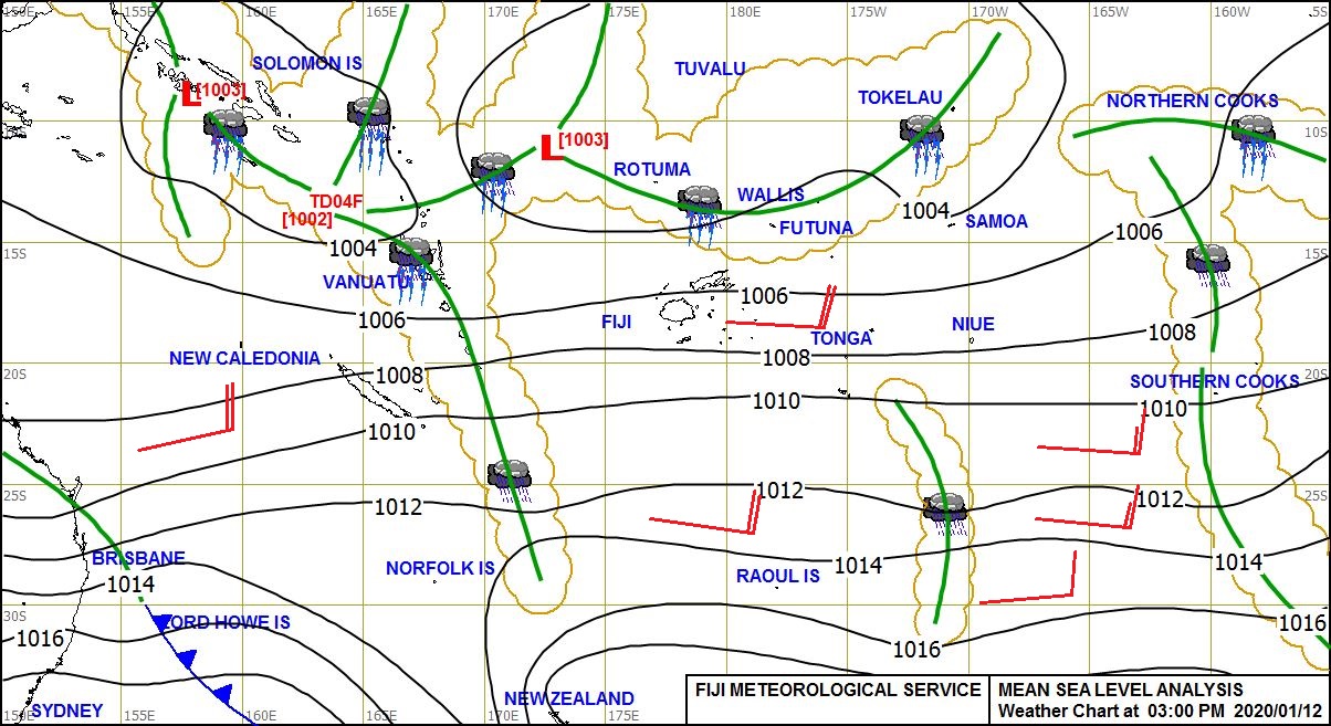
This evening a tropical depression has formed near 10S 163E or between Solomon Islands and northern Vanuatu, called 99P by Guam. See www.met.gov.fj/aifs_prods/0991.jpg
Some global weather models deepen this system during the coming week. They still are coming up with differing possible tracks, and the most likely if to be slowly to the SE at first then the SW or WSW, maybe into the Coral sea by end of the week. If you are entering this area this week then keep an eye on 99P.
There is another depression in the Indian Ocean being watched at present, known as 98P
These systems can be seen at ruc.noaa.gov/tracks/
Rain from last week, compared with previous week, from trmm.gsfc.nasa.gov/trmm_rain/Events/big_global_accumlation.gif, shows wet areas near Palau (first in months), Darwin (from TC FRANCES) and Missouri, USA. The South Pacific convergence zone is more united, but seems to be weakening about and east of Marquesas.
WEATHER ZONES
SPCZ=South Pacific Convergence zone.
SPCZ is strong this week and contains Tropical Depression 99P which is expected to deepen and go SE at first then slowly SW or SSW across Vanuatu an into the Coral Sea. Its future remains uncertain, and it is the system to watch this week.
Forecast for Tropical accumulated rainfall may be seen at from windyty.com
Subtropical ridge (STR)
High in Tasman sea on Monday is expected to travel east across Northern NZ on Tuesday and then travel east along 30S.
Another High is expected to travel east across Bass Strait on Thursday and then across the Tasman Sea and North island by Sunday 7 May.
Australia to New Caledonia:
With the Highs travelling across the South Tasman Sea, and a tropical low likely over Vanuatu or in the Coral Sea, there are lots of East/SE winds between Australia and New Caledonia later this week. Best day of the week to set off is Monday. We may have to wait until Mid-May for the next good enough weather pattern for this voyage.
Departing NZ north for the tropics:
Trough crossing the North Island tonight is bring a southerly gale to Cook Strait with waves washing up on Wellington Roads, and undermining at least one house.
This trough is moving off to east of the North island o Monday and there is good enough weather pattern on Tuesday (passing ridge) for departure to points north. Those intending to g to New Caledonia should keep an eye on that tropical depression, but at this stage a TUESDAY departure looks OK.
Sadly. on Wednesday, Thursday, and Friday a Low is expected to come out of the Southern Ocean and travel NE along NZ east coast and then deepen to east of North Island.
A Tuesday departure should get north quick enough to miss any rough stuff, but a Wednesday or later departure is likely to encounter strong S/SSE winds and 3 to 4 m southerly swells near 30S on Sat/Sun.
The next good-looking opportunity seems to be Saturday 6 May.
New Zealand to the east (Tahiti)
On Wednesday, Thursday, and Friday a Low is expected to come out of the Southern Ocean and travel NE along NZ east coast and then deepen to east of North Island. if we depart Monday or Tuesday then we will need to divert to 25S near 175W to avoid the strong/gale Se winds and heavy swells around this low next weekend. I don't think this is the best weather venture for this route - I think a departure AFTER that trough, from Northland on Sat 6 May (or from Lyttelton on Friday 5 May) could go more direct, perhaps.
Mexico to Marquesas:
A moderate to strong Tehuantepec NE blast of wind near 95W is likely on 5 and 6 May.
Further north, it should be useful north to NW flow for departure anytime this week.
The ITCZ is likely to be between 6N and 2N, and light winds between 3N and 5S on the direct path. Perhaps more wind if you go a bit further west of the rhumb line. Maybe aim for 7N130W then direct.
I shall discontinue this voyage form my list next week unless someone asks for it to continue.
Panama to Galapagos
The forecast is for moderate southerly winds at panama except for a period of light variable winds on 3 and 4 May (best days this week to departs).
I shall discontinue this voyage form my list next week unless someone asks for it to continue.
Galapagos to Marquesas
Trade winds are expected to spread north and fill in this week so that a direct path may be as good as any for starters. However, there may be light winds near 10S from 125 to 135W and it may be an idea to sail around those (or motor thru them).
>>>>>>>>>>>>>>>>>>>>>>>>>>>>>>>>>>>>>>>>>>>>>>>>>>>>>>>>
See my website http://www.metbob.com for more information
Feedback to bob@metbob.com or txt 6427 7762212
Weathergram text only (and translator) is at weathergram.blogspot.co.nz.
Weathergram with graphics is at metbob.wordpress.com,
Click FOLLOW at bottom right to subscribe.
To unsubscribe send a reply email saying LEAVE.
>>>>>>>>>>>>>>>>>>>>>>>>>>>>>>>>>>>>>>>>>>>>>>>>>>
30 April 2017
23 April 2017
Bob Blog 23 April 2017
WEATHERGRAM
YOTREPS
Compiled Sun 23 April 2017
Bob McDavitt's ideas for sailing around the South Pacific.
Disclaimer: Weather is a mix of pattern and chaos; these ideas are from the patterned world.
The state of the ENSO
ENSO is currently neutral and forecast to move towards an El Nino over next few months.
The Atmosphere:
The Southern Oscillation Index SOI (30 day running mean) sums up the weather pattern over the South Pacific as one number. It is based on the standardized difference in the barometer readings between Tahiti and Darwin. When the SOI is more than plus one (standard deviation from its mean) for more than a month we call it a LA NINA event, and when it stays more than minus one we call it an EL NINO event.
El Nino and La Nina are tropical influences on the weather: the La Nina shifts the subtropical ridge away from the equator and the El Nino draws the subtropical ridge closer to the equator. This affects the seasonal weather all around the planet.
From May 2015 to May 2016 we had an extreme El Nino. Then there was a weak La Nina in October 2016, and since then we have had only a weak SOI.
See www.farmonlineweather.com.au/climate/indicator_enso.jsp?c=soi&p=weekly
The Ocean:
The eastern equatorial Pacific Ocean acts as a heat storage area during an El Nino, or becomes cooler than normal during a La Nina. This plays with the heat budget of the atmosphere and thus with the weather patterns. A good measure of the heat is the NINO 3.4 index
The diagram link given below compares the extreme El Nino of 2015/2016 with the previous extreme El Nino in 1997/1998. It also shows there was a period of cooler than normal sea over the past few months, and now things are slightly above normal, but not enough for this to be called El Nino.
Neutral territory is seen at www.farmonlineweather.com.au/climate/indicator_enso.jsp?c=nino34&p=monthly
The International Research Institute of the Climate Prediction Centre compiles data from several ENSO prediction model. This shows that the average of all models is for the NINO 3.4 anomaly to rise for the remainder of 2017 but no more than 1.0--- a rather weak El Nino. As usual, there is a large spread in the model data output, so low confidence.
CPC/IRI predictions are at iri.columbia.edu/our-expertise/climate/forecasts/#ENSO_Forecasts
The Tropics
On 16 April, Cyclone MAARUTHA made landfall on Myanmar with a central pressure of 996hPa. It was the first Northern Hemisphere cyclone to be named for 2017.
Another system, tropical depression CRISING, (4th tropical depression in the NW Pacific for 2017) formed over Palau on 13 April and made landfall over the Philippines, causing some fatalities and washing away buildings.
At present, there is another tropical depression near Palau and another near the south coast of Papua New Guinea. See ruc.noaa.gov/tracks/
Rain from last week, as seen at trmm.gsfc.nasa.gov/trmm_rain/Events/big_global_accumlation.gif, compared with previous week, shows the South Pacific convergence zone is weakening. The ITCZ is about the same, and the convergence zone between Tuvalu and Galapagos is slowly fading.
WEATHER ZONES
SPCZ=South Pacific Convergence zone.
SPCZ is weak and mainly over northern Coral Sea this week. There is still a convergence zone between Tuvalu and Galapagos and another near Southern cooks/ French Polynesia, but these zones are slowly weakening. Tropical accumulated rainfall for next week may be seen at windyty.com
Subtropical ridge (STR)
High in Tasman sea on Monday and Tuesday is expected to travel east across North Island on Wednesday and then fade to east of NZ.
Departing NZ for the tropics:
On Monday, a LOW is expected to be travelling SE off to the east of NZ, and may produce an uncomfortable easterly swell. Tuesday is a public holiday. For the remainder of the week there are likely to be a series of troughs approaching northern NZ from the Tasman sea, and that can be uncomfortable.
Next week, on 1 May, an upper trough is expected to move off to the east of NZ and that is likely to bring a good weather pattern for sailing north from NZ.
Australia to New Caledonia:
Passing surface troughs are too close together next few days, then an upper trough is expected to move off to east of eastern seaboard on Sun 30 April, and that is likely to bring a good weather pattern for sailing to New Caledonia.
Mexico to Marquesas:
A moderate to strong Tehuantepec NE blast of wind near 95W should last until end of 24 April.
Further north, it should be useful north to NW flow for departure until 2May and then lighter WNW winds.
The ITCZ is likely to be between 9 and 6N, and light winds between 3 and 1 N. Perhaps more wind if you go a bit further west of the rhumb line. Maybe aim for 9N130W then direct.
Panama to Galapagos
There are light variable winds at Panama for much of the coming week, but forecast is for moderate southerly winds from 28 April to 5May = not so good for departure.
Galapagos to Marquesas
There is now a zone of light winds on the direct path, and a convergence zone near 5s from 100 to 110W, so recommended 5S 100W to 10S 125W then direct.
>>>>>>>>>>>>>>>>>>>>>>>>>>>>>>>>>>>>>>>>>>>>>>>>>>>>>>>>
See my website www.metbob.com for more information
Feedback to bob@metbob.com or txt 6427 7762212
Weathergram text only (and translator) is at weathergram.blogspot.co.nz.
Weathergram with graphics is at metbob.wordpress.com,
Click FOLLOW at bottom right to subscribe.
To unsubscribe from WordPress: click the "unsubscribe" link on the bottom of the email.
Or, if email wasn't from WordPress then send a reply email saying LEAVE.
>>>>>>>>>>>>>>>>>>>>>>>>>>>>>>>>>>>>>>>>>>>>>>>>>>
16 April 2017
Bob Blog 16 April 2017, Happy Easter
WEATHERGRAM
YOTREPS
Compiled Sun 16 April 2017
Bob McDavitt's ideas for sailing around the South Pacific.
Disclaimer: Weather is a mix of pattern and chaos; these ideas are from the patterned world.
It's Easter again, time for new beginnings.
The track of Cyclone COOK
Cyclone COOK did a fair amount of damage to New Zealand, but not as much as BOLA (March 1988) or GISELLE (April 1968), maybe as much, or slightly more than Cyclone BERNIE (April 1982) or FERGUS (Dec 1996).
MetService have written a blog giving a summary of the track of Cyclone COOK at blog.metservice.com/CycloneCookSummary
It shows the track that was issued on Tuesday as cyclone COOK approached landfall, and the one issued on Friday, with the blue cone showing the spread of uncertainty. These maps show that COOK did not deepen as quickly or as much as the global models calculated, and took a track slightly, but significantly, further east. Nonetheless, it was a formidable feature, with gusts to 209 km/hr at White Island and at least 100 km/hr at Whakatane, and waves over 12 metres recoded at a Bay of Plenty wave buoy. It made landfall near Whakatane in the Bay of Plenty where the barometer bottomed out at 980hPa.
A power failure affected the data coming in from the Bay of Plenty as COOK approached, but using the "Last 48 hours" feature available to registered members at predictwind.com, we can fine-tune where COOK made landfall.
Data from White Island shows that soon after 3pm on Thursday 13 April there was a wind peak with gusts to 113kt/ 209km/hr, then at around 5:30pm the easterly winds turning northerly then counter-clockwise to southerly. We can surmise that the centre started off somewhat west of White Island on approach, and ended up somewhat east of White Island on egress.
At Hicks Bay around 6pm Thursday, wind went from easterly to northerly and gusted to over 60 knots /118 km/hr, so the centre of COOK made landfall west of Hicks Bay.
And Whakatane data shows the peak wind speed just after 6pm Thursday, with wind then turning counter-clockwise from southerly to easterly. This would be on the approach of the centre and sadly we don't have data to see if the wind continued to swing counter-clockwise (in which case landfall was west of Whakatane) or changed to clockwise (in which case landfall was east of Whakatane).
The Tropics
Tropical depression 19F has been slow-moving in the Tonga /Southern Cooks area for most of April so far and is now expected to fade away and maybe track to the west over the next few days. After that it looks as though the South Pacific cyclone season may be spent.
However action is already starting in the Northern Hemisphere, with 01B MAARUTHA in the Bay of Bengal heading for Myanmar (Burma) and a tropical depression (Two) forming near Palau that may move towards Philippines later this week.See ruc.noaa.gov/tracks/
Rain from last week, compared with previous week, at trmm.gsfc.nasa.gov/trmm_rain/Events/big_global_accumlation.gif shows the track of cyclone COOK and MAARUTHA. South Pacific convergence zone is weakening. The ITCZ is returning to normal and the convergence zone between Tuvalu and Galapagos is still there, but now with gaps.
WEATHER ZONES
SPCZ=South Pacific Convergence zone.
SPCZ is weak and mainly over northern Coral Sea this week. There is still a convergence zone between Tuvalu and Galapagos and another near Southern cooks/ French Polynesia, but these zones are slowly weakening. The tropical accumulated rainfall for next week may be seen at windyty.com
Subtropical ridge (STR)
Large High well to east of NZ is intensifying and moving slowly NE, and may reach over 1030hPa on Monday and Tuesday UTC near 33S 148W. There is a squash zone of enhanced easterly winds on north side of this, with large swells. Avoid this squash zone.
Another High is expected to reach over 1030hPa in central Tasman sea from Tuesday to Sunday UTC, and then cross central NZ on Sun/Mon 23/24 April. There is likely to be a squash zone of strong SE winds in the Coral sea. Take care.
Departing NZ for the tropics:
Looks good for departure over next few days, but after Thursday 20 April not so good as there may be easterly swells over 3 metres to north of NZ.
Australia to New Caledonia: Too much easterly this week.
Mexico to Marquesas:
The next strong Tehuantepec NE blast of wind near 95W is expected around 24 to 25 April, and there is a minor one from 19 to 21 April.
Further north, it should be useful north to NW flow for departure until 19 April, and then lighter variable winds until 25 April.
There is likely to be just light winds between 15 and 12N, the NE trade winds should be useful from 12N to 10N---then light wind are likely from 10N to Equator. Perhaps more wind if you go a bit further west of the rhumb line. Maybe aim for equator 130W.
Intertropical convergence zone is spread out between 10N and 5N. And there is still another convergence zone near 5S, but that may ease over next few weeks. South of that zone there should be useful easterly trade winds for sailing to Marquesas.
Panama to Galapagos
OK northerly winds if you depart by 17 April local, otherwise just light SW winds around Panama.
Main convection is likely between 8N and 4N.
Galapagos to Marquesas
There is now a zone of light winds on the direct path, and a convergence zone between 5s and 9S, so need to go as far as 10S maybe 11S to avoid that. Maybe go to waypoints 7S 100W then 11S 135W then direct. The pattern is changing and may well be different in a week or so, so get updates.
>>>>>>>>>>>>>>>>>>>>>>>>>>>>>>>>>>>>>>>>>>>>>>>>>>>>>>>>
See my website www.metbob.com for more information
Feedback to bob@metbob.com or txt 6427 7762212
Weathergram text only (and translator) is at weathergram.blogspot.co.nz.
Weathergram with graphics is at metbob.wordpress.com,
Click FOLLOW at bottom right to subscribe.
To unsubscribe, send a reply email saying LEAVE.
>>>>>>>>>>>>>>>>>>>>>>>>>>>>>>>>>>>>>>>>>>>>>>>>>>
12 April 2017
Cyclone COOK compared with the WAHINE storm.
Cyclone COOK compared with GISELLE (The WAHINE storm/'68)
Posted on April 12, 2017
There are a few tropical cyclones who exit from the tropics quicker than they can unravel.
These may be called 'bolters' and Cyclone COOK is one of these.
Usually when a tropical cyclone departs from the warm seas of the tropics, its eye-wall collapses and the systems weakens. Also, the top of the system is often knocked off by a jetstream at around 30degrees south latitude, so usually the system is no longer a tropical system and is downgraded and referred to as ex-tropical cyclone (or extra tropical cyclone, meaning a cyclone out of the tropics).
The feature that once was Tropical Cyclone COOK has now left the tropics so has lost the word "Tropical", but is still spinning with a zone of stronger winds in a ring near its centre, so may still keep its name and be known as Cyclone COOK (for the meantime).
Cyclone COOK is expected to go through a period of deepening tonight (Wednesday night) as it approaches New Zealand. An ensemble of possible tracks and the average of these, may be seen at www.tropicaltidbits.com/storminfo/16P_gefs_latest.png
This "period of deepening" is expected to take place as Cyclone COOK travels south underneath a jetstream and encounters cooler air, the same process as with any mid-latitude depression deepening. This is expected to deepen the central pressure of Cyclone COOK from 994 to 984hPa overnight.
The team at www.tropicaltidbits.com have compared the track of Cyclone COOK with their extensive database of previous cyclones and listed the closest eight analogues. The most recent of these is BECKY in 2007.
It is interesting that the closest on the list is Cyclone GISELLE in April 1968, known as the "WAHINE Storm", which resulted in the sinking of the Inter-Island ferry MV WAHINE. However, Cyclone GISELLE encountered noticeably colder air near Cook Strait and went through a period of rapid deepening there as a mid-latitude system. In comparison, Cyclone COOK is only expected to deepen by 10hPa on Wednesday night and then its central pressure should remain steady on Thursday. Cyclone GISELLE may be the closest analogue in the database to Cyclone COOK, but with an analogue score of only 0.486 this is to be treated as a questionable analogue.
The Track of GISELLE may be seen at australiasevereweather.com/tropical_cyclones/1967_1968/jtwc/tropical_cyclone_giselle.htm
As mentioned in my previous blog, Cyclone COOK has an accompanying tropical depression located near Southern Cooks. See www.met.gov.fj/aifs_prods/0991.jpg. This accomplice is feeding in moist air and Cyclone COOK is turning this into rain. An analysis of the trajectory of the air reaching NZ with Cyclone Cook (from ready.arl.noaa.gov/HYSPLIT_traj.php) shows that it has come from just south of the Sothern Cooks, with a long path across tropically warm seas.
Cyclone BOLA in 1988 had an accomplice like this
- Cyclone BOLA was a 'lingerer', and Cyclone COOK is a 'bolter', so we can expect a different outcome this time; maybe much the same peak intensity of rain, but in different places and only for a day or less, not for three days in one place.
Be aware that the actual path taken by Cyclone COOK may easily depart from the forecast path, and a small change in track leads to large changes in likely conditions.
================================
09 April 2017
TC COOK not following TC BOLA
In my last blog I made some early comparisons between TC COOK and TC BOLA.
TC COOK has NOT looped around Vanuatu like BOLA - and now is heading for New Caledonia, a place BOLA did not visit---
so it seems to me now that TC COOK is moving faster and differently than TC BOLA did
-so it doesn't compare well with BOLA after all.
See my illustrated edition at tinyurl.com/k4uf2bt for a Track of BOLA and
see metoc.ndbc.noaa.gov/ProductFeeds-portlet/img/jtwc/products/sh1617.gif for a track of COOK.
As a Tropical cyclone with an eye-wall comes south, usually it will encounter increasing westerly winds aloft, often a jetstream. These winds blow the upper parts of the eye-wall downstream and "blow the top off" the feature, ending its tropical status and hastening its weakening.
TC Cook is expected to encounter that Jetstream on Wed--- that's also when it departs the tropics and may lose its eye-wall and its tropical status.
Just one more factor for possible comparison between COOK and BOLA may present itself:
When TC BOLA left the tropics and stalled north of NZ, it was between two jetstreams, and in a region of converging moisture. These combined to form a two-cell vertical circulation, maximising upward motion and thus rainfall. BOLA lingered for three days with this heavy rainmaker within it.
The Jetstreams around remains of BOLA (when it was just NE of NZ) are at tinyurl.com/kdbv6zc from
"A Diagnostic study of the extratropical precipitation resulting from tropical cyclone Bola."
by Mark Sinclair (NIwa) in Monthly Weather Review V 121 p 2690-2707
It is interesting to see that the jetstreams on early Friday local time briefly offer a similar setup to the remains of TC COOK. To see the jetstreams go to www.stormsurfing.com/cgi/display_alt.cgi?a=glob_250
HOWEVER, it seems that TC COOK is moving steadily south now and not likely to linger, , so even if it does carry within it a two-cell vertical circulation / heavy rain maker, this feature is unlikely to stay over any one place too long. Fingers crossed.
+++++++++++++++++++++++++++++++++++++
PS:
Today, 10 April, is the 49th anniversary of the sinking of WAHINE in 1968.
The LOW involved in that event started out as Cyclone GISELLE . It had left the tropics and was weakening as it approached New Zealand, but then encountered a cold front /cold air. The Jetstream above it brought about a new period of deepening--- Taking air away from the top of the feature faster than it can be replaced and thus lowering the central pressure in the low. This sort of double-life for a low doesn't occur often.
Bob McDavitt
Bob's Blog 9 April 2017
WEATHERGRAM
YOTREPS
Compiled Sun 09 April 2017
Bob McDavitt's ideas for sailing around the South Pacific.
Disclaimer: Weather is a mix of pattern and chaos; these ideas are from the patterned world.
TC COOK
There are five features of interest around Australia at present: TC ERNIE to NW of Australia, TC COOK neat Port Vila, TD14(19F) near Niue, a tropical depression near Darwin, and another tropical depression just north of the equator near Micronesia.
The latest satellite imagery (as seen on Google Earth) shows heaps of convective activity around northern Australia and extending to Vanuatu. And provisional track maps from ruc.noaa.gov/tracks/ show a possibly interesting week ahead of us.
The MJO is weak at present, so is not adding to this convection.
TC COOK is, at this stage, worthy of comparison with TC BOLA (a very wet and slow-moving cyclone off eastern NZ in early March 1988), for three possible similarities.
1) A close analysis of BOLA showed it made two loops around Vanuatu, making a slow-moving feature.
TC COOK is in a slow-moving environment when over Vanuatu so it may also do some loops.
2) BOLA's path off to the southeast was blocked by a large HIGH located to east of New Zealand, so that it was knocked slowly to south and southwest lingering near northern NZ. TC COOK may also be blocked by a HIGH and knocked southwest when it becomes extra-tropical and loses its tropical characteristics.
3) BOLA had a tropical depression accomplice to its east that went south over the Niue area as BOLA came south. This helped form converging "rivers of moist air" that hit the Gisborne hills in 1988. TC COOK has a similar accomplice, and the converging rivers of moist air, according to today's data, may be in eastern Bay of Plenty on Friday 14 April. Mind you, there is still plenty of time for this scenario to change, but its worth watching.
Rain from last week, compared with previous week, as seen at trmm.gsfc.nasa.gov/trmm_rain/Events/big_global_accumlation.gif, shows increasing intensity with the tropical lows around ERNIE, north of Darwin, about Vanuatu and from Samoa to Niue. The track of the remains of DEBBIE show up across central New Zealand. The ITCZ is slowly returning to normal and the convergence zone between Tuvalu and Galapagos is still there, but now with gaps. Equatorial America rains seem to be easing.
WEATHER ZONES
SPCZ=South Pacific Convergence zone.
SPCZ is breaking into two this week with its southern half travelling south along e with TC COOK and TD 19F. The northern and NW parts of the convergence zone should stay near 5 to 10S and in the western Coral Sea. Not a good week to go sailing around South Pacific.
Subtropical ridge (STR)
HIGH to east of the South Island is expected to expand over 1030hPa as it travels slowly east along 40S from Monday to Wednesday. The High that is expected to slide form Aussie Bight to southeast over Tasmania by Tuesday is then expected to squeeze around southern NZ by Thursday and intensify as it travels northeast to east of New Zealand on Friday. Another High is expected to do this on Sunday/ Monday.
SO, Highs are dominating eastern NZ this week and mostly blocking Lows from the Tasman, but there is a gap to let lows thru on Friday/Saturday.
Tasman Sea/ NZ troughs.
The thundery front and low crossing New South wales tonight is expected to form a Low in Tasman Sea on Monday and this low will have to wait until Friday to cross over Southern NZ.
It may leave behind a low in the Tasman Sea that may fade there on Monday.
SO, this isn't really a good week for trans-Tasman travel.
Mexico to Marquesas:
Should be a good week to consider departure. No Tehuantepec NE blast of wind expected this week. And a moderate northerly is likely off shore most days this week.
As for waypoints: may need to throw one in to even-out possible direct downwind sailing. Useful NE trade winds to around 8N and then light winds to around 6S. ITCZ is near 10 to 5N, may be an idea to find a gap or go across this directly north to south to minimize squalls.
And there is still another convergence zone near 5S, but that may ease over next few weeks. South of that zone there should be useful easterly trade winds for sailing to Marquesas.
Panama to Galapagos
There should be some useful northerly winds for departure from Panama all this week and over Easter, then the prospect is for light winds. Main convection is likely between 6N and 3 to 2N.
May be some good tail currents and it is worth diverting to 5N 82W for these.
Galapagos to Marquesas
The currents seem to have reverted to a more normal west going set now. However, there are expected to be light winds as far as 5S and a convergence zone of squalls between 2 S and 8S worth avoiding by going south of the rhumb line. Maybe go to waypoints 5S 95W then 9S 123W then direct.
The pattern is changing and may well be different in a week or so, so get updates, maybe be able to cut corners next week.
>>>>>>>>>>>>>>>>>>>>>>>>>>>>>>>>>>>>>>>>>>>>>>>>>>>>>>>>
See my website www.metbob.com for more information
Feedback to bob@metbob.com or txt 6427 7762212
Weathergram text only (and translator) is at weathergram.blogspot.co.nz.
Weathergram with graphics is at metbob.wordpress.com,
Click FOLLOW at bottom right to subscribe.
To unsubscribe from WordPress: click the "unsubscribe" link on the bottom of the email.
Or, if email wasn't from WordPress then send a reply email saying LEAVE.
>>>>>>>>>>>>>>>>>>>>>>>>>>>>>>>>>>>>>>>>>>>>>>>>>>
02 April 2017
Bobgram issued 2 April 2017
WEATHERGRAM
YOTREPS
Compiled Sun 02 April 2017
Bob McDavitt's ideas for sailing around the South Pacific.
Disclaimer: Weather is a mix of pattern and chaos; these ideas are from the patterned world.
MARCH cyclones
Australian Region
4 depressions and 3 Cyclones in March, with DEBBIE reaching cat 4. DEBBIE has become ex-tropical and moved into the Tasman Sea but the rain it dumped inland is still making its way to the coast and places such as Rockhampton are expected to finally reach flood peak on next Wednesday night - with river levels maybe the highest in 63 years.
South Pacific Region Much quieter after a busy February with only 3 depressions in March.
The season so far is shown at en.wikipedia.org/wiki/2016%E2%80%9317_South_Pacific_cyclone_season
Looking at the winds at around 5000ft (the level of the low clouds) averaged over the last week
(at www.cpc.ncep.noaa.gov/products/precip/CWlink/MJO/pentad850winds_total.shtml)
we can see three interesting details.
1) the monsoonal westerly flow around Northern Australia, which was a factor in triggering DEBBIE
2) cyclonic winds around the Tasman Sea
3) Light variable winds along equator between 100W and Peru
If we look at the wind anomalies these features become more marked.
There is almost a reversal of flow in the trade winds between Galapagos and Peru - making it hard for those trying to venture west from Panama. If we look at the sea surface temperatures and currents in this region ...... this shows a weakened north-end to the Humboldt current and a 28 to 30C pool of warm water drifting to Columbia. This is the cause of the record land/bolder slide at Putumayo in SE Columbia with death toll of 254 so far (200 still missing). See tinyurl.com/kb8paod and this may well be the starting of a new El Nino event.
Comparing the averaged isobar maps between February and March at www.esrl.noaa.gov/psd/map/images/fnl/slp_30b.fnl.html shows the build-up of lower-than-normal isobars over eastern Australia and into the Tasman Sea.
During March the subtropical ridge in the South Pacific moved south and intensified as compared to its February position. If this continues then it will be difficult to find a good weather pattern for sailing from NZ to French Polynesia. The good news is that the average position of this feature usually goes starts to go northwards in April.
March rain (as seen at trmm.gsfc.nasa.gov/trmm_rain/Events/thirty_day.html) has been intense about equatorial South America, with other extreme spots marking the various tropical depressions (and DEBBIE). Two points to note: the Intertropical convergence zone across the Pacific remains much drier than normal. And the "mirror convergence zone" that occurs every year in early to mid-March along 5 to 10S between Tuvalu and Galapagos has been intense this year.
The tropics
No cyclones around at this stage. However, there is a risk that the depression 93P/19F now northeast of Samoa may deepen into something more formidable as it travels across the Niue/Southern cooks on Sat/Su 8/9 April. The South Pacific cyclone season is NOT over yet.
For an isobar map see www.met.gov.fj/aifs_prods/0991.jpg and for a track map see www.tropicaltidbits.com/storminfo/93P_gefs_latest.png
Rain from last week, compared with previous week, from trmm.gsfc.nasa.gov/trmm_rain/Events/big_global_accumlation.gif , shows the track of the DEBBIE deluge.
The ITCZ is slowly returning to normal and the convergence zone between Tuvalu and Galapagos is still there, but now with gaps. Equatorial America remains wet, and India remains dry.
WEATHER ZONES
SPCZ=South Pacific Convergence zone.
SPCZ is strengthening this week and already has TD19F near Samoa which is expected to drift slowly south. Other tropical depressions may form in Coral Sea and to south of French Polynesia. Not a good time to go sailing.
Subtropical ridge (STR)
HIGH to east of the South Island is expected to travel slowly east along 40S on Mon /Tuesday. The High that is tonight over Tasmania should trigger a high east of Southland on Monday that should travel NE to 40S 160W by Thursday, and another High in the west Tasman Sea waiting its tur then travelling onto South Island/ central NZ on Friday/Sat.
Tasman Sea/ NZ troughs.
The clouds and low pressure feature left over for DEBBIE are scheduled to cross mainly central NZ on late Monday to Thursday (mainly on Wednesday) with strong wind s and heavy rain. May as well wait if planning to sail away.
Mexico to Marquesas:
The next Tehuantepec NE blast of wind near 95W is expected around 7 to 9 April, then a stronger period from 14 to 16 April.
There seem to be good northerly winds for departure anytime this week.
As for waypoints: Looks to be a good idea to go WSW at first to find a good sailing breeze to aim to encounter the ITCZ near 10N to 5N at 130W. Light winds south of 5N, the trade winds are weaker than normal. Anticipate an extra convergence zone near 2 to 4S on the way to Marquesas.
Panama to Galapagos
Light winds around Panama, often southerly, but there may be a period of 8 -10 knot northerly winds from 7 to 11 April. Light southerly to SW winds from 5N to Galapagos. Main convection is likely between 6N and 4N. May be a good tail current from 3N to Galapagos.
Galapagos to Marquesas
There is now a river of east going current between 2 and 6S west of Galapagos, so need to go as far as 12 to 14S to avoid that... and that's where the winds for sailing are located. Maybe go to waypoints 10S 110W then 13S 125W then direct. The deviation so far to south also avoids the extra convergence zone and its squalls. The pattern is changing and may well be different in a week or so, so get updates.
>>>>>>>>>>>>>>>>>>>>>>>>>>>>>>>>>>>>>>>>>>>>>>>>>>>>>>>>
See my website www.metbob.com for more information
Feedback to bob@metbob.com or txt 6427 7762212
Weathergram text only (and translator) is at weathergram.blogspot.co.nz.
Weathergram with graphics is at metbob.wordpress.com,
Click FOLLOW at bottom right to subscribe.
To unsubscribe send a reply email saying LEAVE.
>>>>>>>>>>>>>>>>>>>>>>>>>>>>>>>>>>>>>>>>>>>>>>>>>>
Subscribe to:
Posts (Atom)