WEATHERGRAM
YOTREPS
Compiled Sun 28 May 2017
Bob McDavitt's ideas for sailing around the South Pacific.
Disclaimer: Weather is a mix of pattern and chaos; these ideas are from the patterned world.
The tropics
There are two tropical depressions on watch tonight-one in the Bay of Bengal (linked with the arrival of the monsoon) and another in the South China sea.
The status of the tropics as summarized at ruc.noaa.gov/tracks/
There has been a build-up of convection in the equatorial Indian Ocean and this is related to an MJO that is heading east. At this time of year it should induce extra convection around the Philippines in a few weeks.
Rain for the past week is at trmm.gsfc.nasa.gov/trmm_rain/Events/big_global_accumlation.gif
Trends in the weekly rain maps show that convection remains strong about Indian Ocean to Philippines. Activity is also increasing along the ITCZ.
In the South Pacific there is a clear path of a small low that descended from an upper trough to reach the surface near Fiji and then travel southeast across southern Tonga to Southern cooks. This system gave brief gales to southern Tonga but was NOT a tropical cyclone. See matangitonga.to/2017/05/23/gales-warning-tongatapu
WEATHER ZONES
SPCZ=South Pacific Convergence zone.
Recent activity in the SPCZ was taken away to the SE by last week's low, and all that is left this week is near 5 to 10S, north of its normal position.
Tropical accumulated rainfall for next week can be seen at windyty.com
Subtropical ridge (STR)
High in the Tasman Sea is expected to travel east along 30S this week.
The next High is expected to spend this week over interior of Australia. This means that the nights are now long enough to cool and densify the over continental Australia encouraging the STR to shift north. This High is expected to stretch towards Southern NZ next weekend.
Australia to New Caledonia:
The GO EAST RALLY took the opportunity to sail last week and are now (mostly) in Noumea.
There is a trough crossing Brisbane over next few days so good idea to let that pass and then latch on to the Southerly winds that follow, around Wednesday, for departure.
Departing NZ to the north for the tropics:
The DOWN UNDER RALLY took the opportunity to sail north on Saturday (27th) along with lots of yachts from Opua/Marsden cove. The strong subtropical ridge is likely to ensure a slow trip; however, it should also keep nasty troughs at bay.
A trough is expected to move on to NZ by late Tuesday followed by a Low traveling NE across the country (in upper SW winds) from Thursday to Sunday, followed by strong SE winds.
So those not departing on Monday should wait until AFTER next weekend (Queens Birthday Holiday on Monday) for next good departure opportunity.
New Zealand (Northland) to the east (Tahiti)
Avoid departing on Tuesday because of a likely passing trough.
A Low is expected to take its time crossing the northern NZ region from Thu 1 to Mon 5 June. Any departure from Wed 31 May is likely to encounter too much in the way of easterly winds from that low by Saturday. SO, either go Monday or wait until next week.
>>>>>>>>>>>>>>>>>>>>>>>>>>>>>>>>>>>>>>>>>>>>>>>>>>>>>>>>
See my website www.metbob.com for more information
Feedback to bob@metbob.com or txt 6427 7762212
Weathergram text only (and translator) is at weathergram.blogspot.co.nz.
Weathergram with graphics is at metbob.wordpress.com,
Click FOLLOW at bottom right to subscribe.
To unsubscribe send a reply email saying LEAVE.
>>>>>>>>>>>>>>>>>>>>>>>>>>>>>>>>>>>>>>>>>>>>>>>>>>
28 May 2017
21 May 2017
Bob Blog 21 May
WEATHERGRAM
YOTREPS
Compiled Sun 21 May 2017
Bob McDavitt's ideas for sailing around the South Pacific.
Disclaimer: Weather is a mix of pattern and chaos; these ideas are from the patterned world.
=================================
The state of the ENSO
In the Atmosphere:
The Southern Oscillation Index SOI (30 day running mean) sums up the weather pattern over the South Pacific as one number. It is based on the standardized difference in the barometer readings between Tahiti and Darwin. When the SOI is more than plus one (standard deviation from its mean) for more than a month we call it a LA NINA event, and when it stays more than minus one we call it an EL NINO event.
El Nino and La Nina are tropical influences on the weather: the La Nina shifts the subtropical ridge away from the equator and the El Nino draws the subtropical ridge closer to the equator. This affects the seasonal weather all around the planet.
From May 2015 to May 2016 we had an extreme El Nino. Then there was a weak La Nina in October 2016, and then we had weak plus/minus events. However over the past few weeks the SOI has dived to below minus 1 (-10 in the graph scale used here). If this value is held for three more weeks then we are having a new EL NINO.
A trend toward El Nino as seen at www.farmonlineweather.com.au/climate/indicator_enso.jsp?c=soi&p=weekly
In the Ocean:
The eastern equatorial Pacific Ocean acts as a heat storage area during an El Nino, or becomes cooler than normal during a La Nina. This plays with the heat budget of the atmosphere and thus with the weather patterns.
There were warm seas during the El Nino of 2015/2016 and cooler seas late last year and earlier this year. Since Feb/Mar the seas in the target area have warmed, but not yet enough to call this an El NINO (as far as the ocean is concerned).
Seas are warm but not yet an El Nino, as seen at www.farmonlineweather.com.au/climate/indicator_enso.jsp?c=nino34&p=monthly
The International Research Institute of the Climate Prediction Centre compile data from several ENSO prediction models. Looking at the Nino3-4 parameter, most models do NOT go for an El NINO, but they do go for higher than normal sea temperatures, with a reasonably flat trend for the next year.
CPC/IRI predictions are at
iri.columbia.edu/our-expertise/climate/forecasts/#ENSO_Forecasts
In summary: the atmosphere is starting to show some El Nino traits, but is only weakly being supported by the ocean. This means that although we may see some weather features typical of El Nino over the next month or so, there is also room for variation and other patterns to appear.
===================
The Monsoon
AT this time of year, the noon-day sun is over 20N-the thickest part of northern India. Up until now the cooler oceanic surface winds have been held off India mainland in spite of the extra heating from the overhead sun as it travelled north. One factor in this has been the jetstreams over 30N, the Himalayas. However, we have now entered that critical part of the year, where the jetstreams shift over the Himalayas.
Himalaya is the only part of planet earth that touches the stratosphere, and some call it our "third pole". Without jetstreams, Everest becomes climbable, and we are now entering the Everest climbing season (last around 7-10 days). This is such a critical event in the annual cycle of the planet (more so than a solstice or equinox) that some meteorologists like to use it as to demark the beginning of a new meteorological year. It seems that other seasonal parameters such as ENSO seem to start and end around this time of the year. Anyway, the absence of jetstreams over Himalaya is the very event that allows the cooler oceanic surface winds to finally enter India, bringing monsoonal rain. A Monsoon arrival map may be found at www.imd.gov.in/pages/monsoon_main.php and is updated almost daily. Enjoy.
========================
The tropics
It is amazing what difference one week can make, not just in politics, but also in tropical weather. Whereas last week we had cyclones in both hemispheres, this week things have quietened and there are no cyclones around (just a tropical low north of the Philippines).
There has been a build up of convection in the equatorial Indian Ocean and this is related to an MJO that is heading east (not monsoonal). At this time of year it should induce extra convection around the Philippines in a few weeks.
Rain for the past fortnight is available at trmm.gsfc.nasa.gov/trmm_rain/Events/big_global_accumlation.gif
===============
WEATHER ZONES
SPCZ=South Pacific Convergence zone.
AN upper trough is building cloud over Fiji tonight. This is expected is to descend into a LOW that forms over Southern Tonga on Monday and the Niue area on Tuesday/Wednesday UTC, and then moves off to the SE. and fades. Avoid. Likely to be squally near this low.
Subtropical ridge (STR)
The force is strong with the STR this week. One High over northern New Zealand on Monday is expected to travel to east of NZ along 35S. There is likely to be a squash zone of enhanced SE winds on the northern side of this High from Monday to Thursday UTC.
Next HIGH from the Australian east coast on Mon 22 May is expected to travel east over central NZ on Wednesday 24 May.
Then another HIGH is expected to travel east along 25 to 30S across northern Tasman Sea from Fri 26 to Tue 30 may.
Australia to New Caledonia:
The GO EAST RALLY is likely to depart South Port on early Tuesday:
This should work thanks to a southerly component in the wind along the way on Wednesday as a trough forms between New Caledonia and Fiji.
Departing NZ to the north for the tropics:
Good opportunity for departing NZ is expected AFTER a trough passes off to the east on Thu 25 May.
New Zealand to the east (Tahiti)
Light winds are Ok for departure on Mon22/Tue 23 May. After that things get complicated.
>>>>>>>>>>>>>>>>>>>>>>>>>>>>>>>>>>>>>>>>>>>>>>>>>>>>>>>>
See my website www.metbob.com for more information
Feedback to bob@metbob.com or txt 6427 7762212
Weathergram text only (and translator) is at weathergram.blogspot.co.nz.
Weathergram with graphics is at metbob.wordpress.com,
Click FOLLOW at bottom right to subscribe.
To unsubscribe send a reply email saying LEAVE.
>>>>>>>>>>>>>>>>>>>>>>>>>>>>>>>>>>>>>>>>>>>>>>>>>>
14 May 2017
Bob Blog 14 May
WEATHERGRAM
YOTREPS
Compiled Sun 14 May 2017
Bob McDavitt's ideas for sailing around the South Pacific.
Disclaimer: Weather is a mix of pattern and chaos; these ideas are from the patterned world.
Tropical Cyclones DONNA, ELLA and ADRIAN
Cyclone DONNA was tripped over by Mare island in the Loyalty Group and faded quickly with its clouds merging into a trough that crossed New Zealand on Friday. Looking at its track it seems that DONNA had problems when its forward edge started encountering the high ground of New Caledonia. This can still be seen at www.met.gov.fj/aifs_prods/65648.html
Cyclone ELLA is still travelling slowly west, travelling near Rotuma tonight, and expected to weaken on Monday but may still have squalls when it gets near the northern Islands of Vanuatu on Wednesday. This can be seen at www.met.gov.fj/aifs_prods/65663.html
Cyclone ADRAIN had a brief life starting Wed 10 May (UTC) when it formed in the NE Pacific. Their cyclone season usually "opens" on 15 May, and ADRIAN now holds the record as "earliest cyclone" for the NE Pacific. It dissipated on 11 May. See watchers.news/2017/05/10/tropical-storm-adrian-forms-in-ne-pacific-as-the-earliest-on-record/
The rain from cyclone ELLA in the past week is the highlight of this week's rain map, at trmm.gsfc.nasa.gov/trmm_rain/Events/big_global_accumlation.gif, especially when compared with last week (which is showing DONNA's rain). Also note that the extra convergence zone that was between Marquesas and Galapagos a fewe weeks ago has now faded away.
WEATHER ZONES
SPCZ=South Pacific Convergence zone.
TC ELLA is expected to weaken on Monday but may bring some squalls to norther Vanuatu are aby Wednesday. Apart from that, the SPCZ this week is expected to linger from Solomons to the area between Vanuatu and Fiji. Another convergence zone is likely to longer along 15S between Samoa and the area west of Southern Cooks.
Subtropical ridge (STR)
High over northern New Zealand on Monday is expected to travel to east of NZ along 35 to 40S. There is likely to be a squash zone of enhanced SE winds on the northern side of this High from Wednesday to Friday UTC between Rarotonga and Tonga.
Next HIGH from the Australian bight is expected to linger over Tasmania from Wednesday 17 to Friday 19 May, then travel NE across the Tasman Sea to reach North island around Monday 22 May, and then across the Tasman Sea next week reaching northern New Zealand by Friday 19 May.
Australia to New Caledonia:
The GO EAST RALLY is rearing to go soon.See www.downunderrally.com/about-go-east
The HIGH in the south Tasman Sea from Wednesday is likely to maintain too much SE trade winds along the route until Sat 20 May. Then there should be a weak passing trough on Sunday, but today's data is showing this is NO LONGER EXPECTED to be followed by a change to SW winds. The next possibility for a reasonable weather pattern for departure is around Thu 25 May, perhaps. Things my change and bring this forward, so keep tuned.
Departing NZ to the north for the tropics:
The current weather of opportunity is quickly closing as the next incoming trough is expected to bring NE winds onto Northland from Tuesday. Low in southern Tasman Sea is expected to deepen from Monday to Wednesday as it travels southeast then east, and then across central NZ on Thursday. AT this stage, a departure on Friday 19 or Sat 20 May is looking good.
New Zealand to the east (Tahiti)
After the Wednesday/Thursday trough we may need to wait a day or so for the southwest winds that follow that trough to ease. Then around Sat 20 May there should be an OK opportunity for departure.
Mexico to Marquesas:
Off NW Mexico, there should be a useful north to NW flow for departure for first half of this week, but then these winds may become lighter and more variable for a few days.
The ITCZ is likely to be between 9N and 3N, and light winds between 8N and 5N.
Perhaps there is better sailing if you aim for a waypoint WEST of the direct path this week near maybe EQ131W.
Panama to Galapagos
Light mostly southerly winds off Panama this week, so it's a motoring start and there are moderate SW winds between Panama and Galapagos especially from 16 to 20 May UTC (Mon to Friday local).
Convective clouds with variable winds and squalls likely from 6N to 3N.
Galapagos to Marquesas
There is still a zone of light winds about the equator near 100 to 105W, so go southwest at first. Then, when in the trades, we can go direct.
Maybe a convergence zone with squalls near 5S 100W, avoid.
>>>>>>>>>>>>>>>>>>>>>>>>>>>>>>>>>>>>>>>>>>>>>>>>>>>>>>>>
See my website www.metbob.com for more information
Feedback to bob@metbob.com or txt 6427 7762212
Weathergram text only (and translator) is at weathergram.blogspot.co.nz.
Weathergram with graphics is at metbob.wordpress.com,
Click FOLLOW at bottom right to subscribe.
To unsubscribe, send a reply email saying LEAVE.
>>>>>>>>>>>>>>>>>>>>>>>>>>>>>>>>>>>>>>>>>>>>>>>>>>
09 May 2017
TC ELLA for the remainder of the week
The tropical depression we have been watching over northern Tonga for the first part of this week has now deepened into Cyclone ELLA. This is travelling west along 16S as cat1.
ELLA is expected to become category 2 (winds up to around 50 knots may gust to 75 knots) and curve to the south reaching the Lau group on Friday and over the weekend.
For latest up to date details on ELLA go to www.met.gov.fj/aifs_prods/65663.html
or if you only have email, send one to query@saildocs.com, no subject needed, with the message:
SEND http://www.met.gov.fj/aifs_prods/20036.txt
=====================================================
07 May 2017
Bob Blog 7 May 2017
WEATHERGRAM
YOTREPS
Compiled Sun 7 May 2017
Bob McDavitt's ideas for sailing around the South Pacific.
Disclaimer: Weather is a mix of pattern and chaos; these ideas are from the patterned world.
Tropical Cyclone DONNA
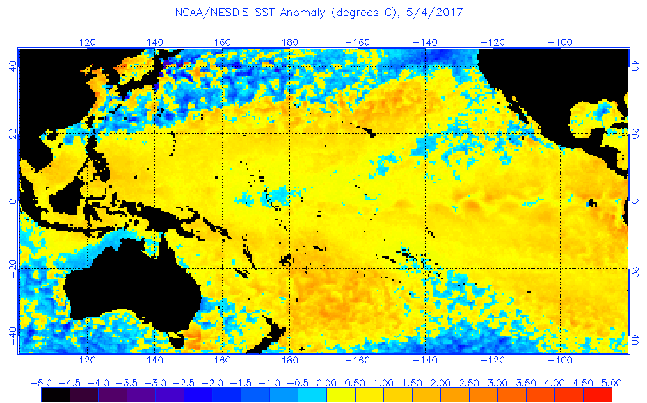
DONNA may have formed a few days "out of season". However, this should be no great surprise as the sea temperatures all around the tropical Pacific are warmer than normal and that's the trigger.
Sea Surface temperature anomalies may be seen at www.ospo.noaa.gov/data/sst/anomaly/2017/anomp.5.4.2017.gif
These warmer than normal seas are already breeding tropical depressions in the NE Pacific, and their "Cyclone Season" is meant to start on 15 May, but there is already an interesting collection of possible depressions off the Honduras west coast this week.
To see how the annual weather cycle and the seasons are working out, check out the average isobar maps for April at
www.esrl.noaa.gov/psd/map/images/fnl/slp_30b.fnl.html
Back in March, the subtropical ridge was near latitudes 30 in both N and S hemispheres. Then, in April, that ridge noticeable shifted NORTHWARDS, especially over the mainlands of Australia and South America, and in the northern Hemisphere it has weakened over the mainlands of Eurasia and North America.
The anomaly map shows that that the troughy area that was over Australia in March has been replaced by a ridgey area--- it seems to have weakened and shifted to the NZ area. This is consistent with the Tasman Tempest and Cyclone Cook events that brought NZ record April rainfall.
The Last 30 days of rainfall, and its anomaly, as seen at TRMM
trmm.gsfc.nasa.gov/trmm_rain/Events/thirty_day.html
clearly shows that the wetter than normal conditions over NZ. This also shows Vanuatu had a wetter than normal April.
The Tropics
TC DONNA reached Cat 4 early today and is now Cat 3 and continuing to curve South then south-southeast then southeast reaching the Iles des Pins area by around 5pm local time Wednesday. By then it should have weakened to Cat 2.
Its latest official track for DONNA is available from www.met.gov.fj/aifs_prods/65661.html
A trough is crossing that Tasman Sea and moving onto New Zealand later this week. This trough should capture the remains of DONNA when it exits from the tropics on Thursday and help push them south-eastwards off to the east of NZ on Friday/Saturday. DONNA is likely to lose strength when it leaves the tropics because it will encounter a Jetstream and get decapitated. Cyclone COOK, by way of comparison, was able to get between two jetstreams and thereby deepen as it approached NZ.
There is a small tropical depression over the Tonga area tonight. It is expected to fade as it moves off to the north of Fiji over next few days.
The rain from cyclone DONNA in the past few days is the highlight of this week's rain map at trmm.gsfc.nasa.gov/trmm_rain/Events/big_global_accumlation.gif
especially when compared with last week.
WEATHER ZONES
SPCZ=South Pacific Convergence zone.
SPCZ is expected to remain strong in a zone from Tonga to Southern Cooks.
Subtropical ridge (STR)
High over northern New Zealand tonight is travelling off to the east.
Next HIGH from the Australian bight is expected to travel east across Tasmania on Friday 12 May, and then across the Tasman Sea next week reaching northern New Zealand by Friday 19 May.
Australia to New Caledonia:
The GO EAST RALLY is rearing to go soon.
SEE www.downunderrally.com/about-go-east
The HIGHS crossing the Tasman Sea are producing too much of a Southeast wind on this route for a good sail to Noumea. The Low that is expected to be crossing the Tasman Sea this week (with a trough that captures the remains of DONNA) is too far south to turn the winds southerly long enough for a nice voyage to Noumea. SO, may as well stay put this week.
And during next week there is another HIGH, maintaining more SE winds along the route until at least Thu 18 May. Perhaps soon after that there should be a favourable swing of wind. More about this next week.
Departing NZ to the north for the tropics:
Trough is moving onto New Zealand from the Tasman Sea, and crossing the North Island on Thursday. Because it is preceded by increasing NE winds, may as well stay put until this trough has gone. AT this stage, a departure on Friday 12 or Sat 13 May is looking good.
New Zealand to the east (Tahiti)
After the Thursday trough we may need to wait a day or so for the southerly winds that follow that trough to ease. Then around Sat 13 or Sun 14 May there should be an OK opportunity for departure.
Mexico to Marquesas:
If a tropical depression does deepen off the Honduras coast next few days then it should go north and make landfall near the Guatemala/Mexico border by Sun 14 May, and thus not affect anyone departing from La Paz area. Keep an eye out just in case.
Off NW Mexico, there should be a useful north to NW flow for departure anytime this week, but it may fade next week.
The ITCZ is likely to be between 7N and 2N, and light winds between 7N and 2N and from 1S to 3S. Different from last week, and perhaps better sailing winds if you aim for a waypoint EAST of the direct path this week near maybe EQ 123W.
Panama to Galapagos
Southerly winds off Panama are light until Monday then expected to become moderate until wed 17 May.
SO, Sunday/Monday offer the best possible departure conditions this week.
At 7N we may be deflected to west southwest by the S/SSE winds - sadly that's into the main convective clouds with squalls.
Galapagos to Marquesas
There is still a zone of light winds about and wets of Galapagos.
To avoid these, go to 5N 93W and then can go direct.
Maybe a convergence zone with squalls near 9S 120W, perhaps.
>>>>>>>>>>>>>>>>>>>>>>>>>>>>>>>>>>>>>>>>>>>>>>>>>>>>>>>>
See my website www.metbob.com for more information
Feedback to bob@metbob.com or txt 6427 7762212
Weathergram text only (and translator) is at weathergram.blogspot.co.nz.
Weathergram with graphics is at metbob.wordpress.com,
Click FOLLOW at bottom right to subscribe.
To unsubscribe, send a reply email saying LEAVE.
>>>>>>>>>>>>>>>>>>>>>>>>>>>>>>>>>>>>>>>>>>>>>>>>>>
YOTREPS
Compiled Sun 7 May 2017
Bob McDavitt's ideas for sailing around the South Pacific.
Disclaimer: Weather is a mix of pattern and chaos; these ideas are from the patterned world.
Tropical Cyclone DONNA
DONNA may have formed a few days "out of season". However, this should be no great surprise as the sea temperatures all around the tropical Pacific are warmer than normal and that's the trigger.
Sea Surface temperature anomalies may be seen at www.ospo.noaa.gov/data/sst/anomaly/2017/anomp.5.4.2017.gif
These warmer than normal seas are already breeding tropical depressions in the NE Pacific, and their "Cyclone Season" is meant to start on 15 May, but there is already an interesting collection of possible depressions off the Honduras west coast this week.
To see how the annual weather cycle and the seasons are working out, check out the average isobar maps for April at
www.esrl.noaa.gov/psd/map/images/fnl/slp_30b.fnl.html
Back in March, the subtropical ridge was near latitudes 30 in both N and S hemispheres. Then, in April, that ridge noticeable shifted NORTHWARDS, especially over the mainlands of Australia and South America, and in the northern Hemisphere it has weakened over the mainlands of Eurasia and North America.
The anomaly map shows that that the troughy area that was over Australia in March has been replaced by a ridgey area--- it seems to have weakened and shifted to the NZ area. This is consistent with the Tasman Tempest and Cyclone Cook events that brought NZ record April rainfall.
The Last 30 days of rainfall, and its anomaly, as seen at TRMM
trmm.gsfc.nasa.gov/trmm_rain/Events/thirty_day.html
clearly shows that the wetter than normal conditions over NZ. This also shows Vanuatu had a wetter than normal April.
The Tropics
TC DONNA reached Cat 4 early today and is now Cat 3 and continuing to curve South then south-southeast then southeast reaching the Iles des Pins area by around 5pm local time Wednesday. By then it should have weakened to Cat 2.
Its latest official track for DONNA is available from www.met.gov.fj/aifs_prods/65661.html
A trough is crossing that Tasman Sea and moving onto New Zealand later this week. This trough should capture the remains of DONNA when it exits from the tropics on Thursday and help push them south-eastwards off to the east of NZ on Friday/Saturday. DONNA is likely to lose strength when it leaves the tropics because it will encounter a Jetstream and get decapitated. Cyclone COOK, by way of comparison, was able to get between two jetstreams and thereby deepen as it approached NZ.
There is a small tropical depression over the Tonga area tonight. It is expected to fade as it moves off to the north of Fiji over next few days.
The rain from cyclone DONNA in the past few days is the highlight of this week's rain map at trmm.gsfc.nasa.gov/trmm_rain/Events/big_global_accumlation.gif
especially when compared with last week.
WEATHER ZONES
SPCZ=South Pacific Convergence zone.
SPCZ is expected to remain strong in a zone from Tonga to Southern Cooks.
Subtropical ridge (STR)
High over northern New Zealand tonight is travelling off to the east.
Next HIGH from the Australian bight is expected to travel east across Tasmania on Friday 12 May, and then across the Tasman Sea next week reaching northern New Zealand by Friday 19 May.
Australia to New Caledonia:
The GO EAST RALLY is rearing to go soon.
SEE www.downunderrally.com/about-go-east
The HIGHS crossing the Tasman Sea are producing too much of a Southeast wind on this route for a good sail to Noumea. The Low that is expected to be crossing the Tasman Sea this week (with a trough that captures the remains of DONNA) is too far south to turn the winds southerly long enough for a nice voyage to Noumea. SO, may as well stay put this week.
And during next week there is another HIGH, maintaining more SE winds along the route until at least Thu 18 May. Perhaps soon after that there should be a favourable swing of wind. More about this next week.
Departing NZ to the north for the tropics:
Trough is moving onto New Zealand from the Tasman Sea, and crossing the North Island on Thursday. Because it is preceded by increasing NE winds, may as well stay put until this trough has gone. AT this stage, a departure on Friday 12 or Sat 13 May is looking good.
New Zealand to the east (Tahiti)
After the Thursday trough we may need to wait a day or so for the southerly winds that follow that trough to ease. Then around Sat 13 or Sun 14 May there should be an OK opportunity for departure.
Mexico to Marquesas:
If a tropical depression does deepen off the Honduras coast next few days then it should go north and make landfall near the Guatemala/Mexico border by Sun 14 May, and thus not affect anyone departing from La Paz area. Keep an eye out just in case.
Off NW Mexico, there should be a useful north to NW flow for departure anytime this week, but it may fade next week.
The ITCZ is likely to be between 7N and 2N, and light winds between 7N and 2N and from 1S to 3S. Different from last week, and perhaps better sailing winds if you aim for a waypoint EAST of the direct path this week near maybe EQ 123W.
Panama to Galapagos
Southerly winds off Panama are light until Monday then expected to become moderate until wed 17 May.
SO, Sunday/Monday offer the best possible departure conditions this week.
At 7N we may be deflected to west southwest by the S/SSE winds - sadly that's into the main convective clouds with squalls.
Galapagos to Marquesas
There is still a zone of light winds about and wets of Galapagos.
To avoid these, go to 5N 93W and then can go direct.
Maybe a convergence zone with squalls near 9S 120W, perhaps.
>>>>>>>>>>>>>>>>>>>>>>>>>>>>>>>>>>>>>>>>>>>>>>>>>>>>>>>>
See my website www.metbob.com for more information
Feedback to bob@metbob.com or txt 6427 7762212
Weathergram text only (and translator) is at weathergram.blogspot.co.nz.
Weathergram with graphics is at metbob.wordpress.com,
Click FOLLOW at bottom right to subscribe.
To unsubscribe, send a reply email saying LEAVE.
>>>>>>>>>>>>>>>>>>>>>>>>>>>>>>>>>>>>>>>>>>>>>>>>>>
03 May 2017
TC DONNA
The tropical depression that has been lingering around to northeast of Vanuatu got its act together last might and is now a Cat 2 tropical cyclone called TC DONNA.
It is heading southwest towards Sola in northern Vanuatu where it should arrive around 5pm Thursday local and intensify of Cat 3, with winds near centre around 64 to 85 knots.
For an updated track map for TC DONNA see www.met.gov.fj/aifs_prods/65661.html
On Friday, TC DONNA is expected to maintain Cat 3 and turn south-southeast-wards. If it continues its current pace, TC DONNA at this stage, is likely to reach the Port Vila area by late Sunday. Then it may start to travel faster and weaken passing the Tanna area around Monday.
Too far away at this stage to be sure, but next week as TC DONNA leaves the tropics, one likely scenario is for it be captured by the trough which is likely then to be moving from the Tasman Sea towards NZ. This should take its remains south-eastwards towards NZ's East Cape by around Friday 12 May.
Any vessels on their way from NZ to Fiji at present should aim for a waypoint east of their direct path so that they may be in position when the winds around Fiji turn to be from the NE early next week. the trough that contains DONNA is not expected to get past 175E until after Wed 10 May
Any vessels stopping at Minerva are advised that a large HIGH is now travelling east from the Tasman Sea across NZ this weekend and then off to east of NZ early next week. This HIGH enhances the trade winds on its northern side, so there is likely to be a period of easterly winds at Minerva around 20 gust 30 knots (maybe a bit more) from end of Friday 5 May to Thursday 11 May, Then a trough on Friday 12 /Sat 13/Sun 14 May.
Bob McDavitt
Subscribe to:
Posts (Atom)