WEATHERGRAM
YOTREPS
Compiled Sun 15 January 2017
Bob McDavitt's ideas for sailing around the South Pacific.
Disclaimer: Weather is a mix of pattern and chaos; these ideas are from the
patterned world.
A new edition (the third) of The Pacific Crossing Guide by Kitty Van Hagen is
now available, and this edition gives reference to MetBob as well. So, I
recommend it as a useful source of info if you are planning on voyaging around
the South Pacific this year.
Google it and buy from you favourite supplier/Bookshop. The nearest to me is
www.boatbooks.co.nz/cruzeswpac.html#30125
ANTARCTICA CUP
This week Lisa Blair is setting off for the "Antarctica Cup" racetrack,
departing from Albany in southwest Australia. See
www.acronautic.com/antartica-cup-ocean-race/
I consider her to be a worthy sailor and I shall be sponsoring this adventure by
watching the weather for her. Lisa is doing this to spread the word about
Climate change- her vessel has been renamed CAN for Climate Action Now. This is
indeed a worthy cause and I encourage you to track her proceedings at
lisablairsailstheworld.com/blog or www.facebook.com/LisaBlairSailstheWorld/ and
spread the word.
Her departure was meant to be today but has been delayed a few days by an
electrical fault.
When is it best to depart America for Galapagos/Marquesas?
The South Pacific cyclone season ends in April, and the Northeast Pacific
cyclone season starts in June, so it is generally understood that the best time
to depart San Diego or Western Mexico or Panama for Galapagos or Marquesas is
between mid-February and early June, crossing the equatorial area between
cyclone seasons.
In an El Nino year there is a low risk of strong winds near Marquesas in
April/May - but this is NOT an El Nino year. Departing too early means possibly
being caught in a zone of light winds between equator and 10S, especially east
of 100W, but there are usually some useful currents to follow.
One thing I'd like to point out, is that soon after the March 21st equinox (when
the overhead sun starts shifting northwards into the northern Hemisphere) the
prevailing winds between Panama and the equator swing from "occasionally NE" to
"mostly SW", so that makes departures from Panama in April onwards difficult.
This can be gleaned by checking the monthly averaged ocean winds from
Scatterometer data as gathered for sailors by the crew of at SV PITUFA at
http://www.pitufa.at/oceanwinds/
The Tropics
The Tropics are still having a quiet period between active cyclones. There is a
little activity over the sea off southeast Asia: Tropical depression 01W (ONE)
is heading for southern parts of Vietnam, as seen at metoc.ndbc.noaa.gov/
Rain maps from trmm.gsfc.nasa.gov/trmm_rain/Events/big_global_accumlation.gif
show that activity is on the decrease around Indonesia and SE Asia, and on the
increase around central and NE of Australia
WEATHER ZONES
SPCZ=South Pacific Convergence zone.
SPCZ is active this week mainly east of 180, and this reflects the warmer than
normal sea temperatures between Fiji and Tahiti. The depression that is tonight
to south of Niue (and has been around a few days now) is expected to remain
slow-moving and fade by nid week. However, a new LOW is expected to form to
southeast of Rarotonga and south of Papeete on Wednesday, and this feature
should deepen and travel slowly east late this week, bringing squally NW winds
to parts of FP French Polynesia and cooler clearer southerly winds + SW swells
to Southern Cooks.
Tropical accumulated rainfall for next week may be seen at windyty.com
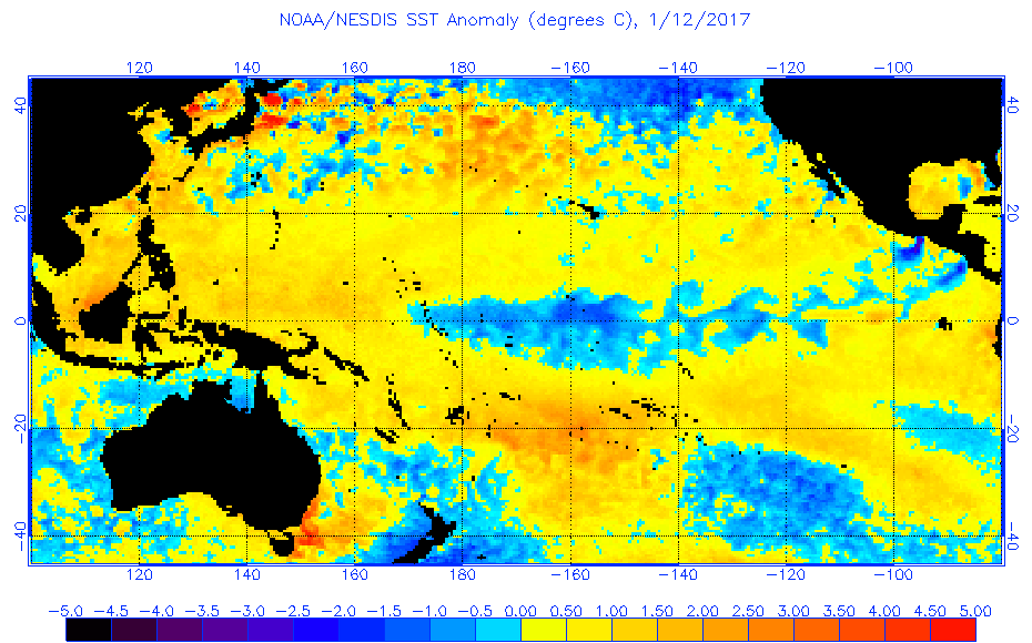
Sea Surface temperature anomalies may be seen at
www.ospo.noaa.gov/data/sst/anomaly/2017/anomp.1.12.2017.gif
Outlook for next cyclone:
Still too far away to be sure, but Meteo France are picking an increasing
likelihood of tropical cyclone formation over Vanuatu between 22 and 28 Jan as
seen at www.meteo.nc/nouvelle-caledonie/cyclone/coin-des-experts
This prognosis takes into account the MJO cycle (rather weak at present) and sea
surface temperature changes.
Subtropical ridge (STR)
High in North Tasman sea on Sunday is expected to fade over northern NZ by
Wednesday.
A new High is expected to spread into the south Tasman Sea on Thursday, and
cross NZ area on Friday.
Tasman Sea/NZ Area troughs.
A deep low is expected to cross southern NZ on Wednesday bringing strong winds
and a brief cold SW change on Thursday.
After that Thursday/Friday High, be on watch for a LOW from central Australia to
deepen quickly over the warmer than normal seas off Sydney on Friday, and then
deepen more as it crosses Tasman Sea on Saturday and central NZ on
Sunday/Monday. Avoid.
>>>>>>>>>>>>>>>>>>>>>>>>>>>>>>>>>>>>>>>>>>>>>>>>>>>>>>>>
Follow me on Facebook at www.facebook.com/metbobnz/
See my yotpak at boatbooks.co.nz/weather.html for terms used.
See my website http://www.metbob.com for information on tailor-made voyage
forecasts-
Feedback to bob@metbob.com.
Tell others that to subscribe they should email me.
Weathergram text only (and translator) is at weathergram.blogspot.co.nz.
Weathergram with graphics is at metbob.wordpress.com,
Click FOLLOW at bottom right to subscribe.
To unsubscribe send a reply email saying LEAVE.
>>>>>>>>>>>>>>>>>>>>>>>>>>>>>>>>>>>>>>>>>>>>>>>>>>>>>>>
Followers
Translator
Bob McDavitt's ideas for sailing weather around the South pacific
Subscribe to:
Post Comments (Atom)
No comments:
Post a Comment