WEATHERGRAM
YOTREPS
Compiled Sun 26 March 2017
Bob McDavitt's ideas for sailing around the South Pacific.
Disclaimer: Weather is a mix of pattern and chaos; these ideas are from the patterned world.
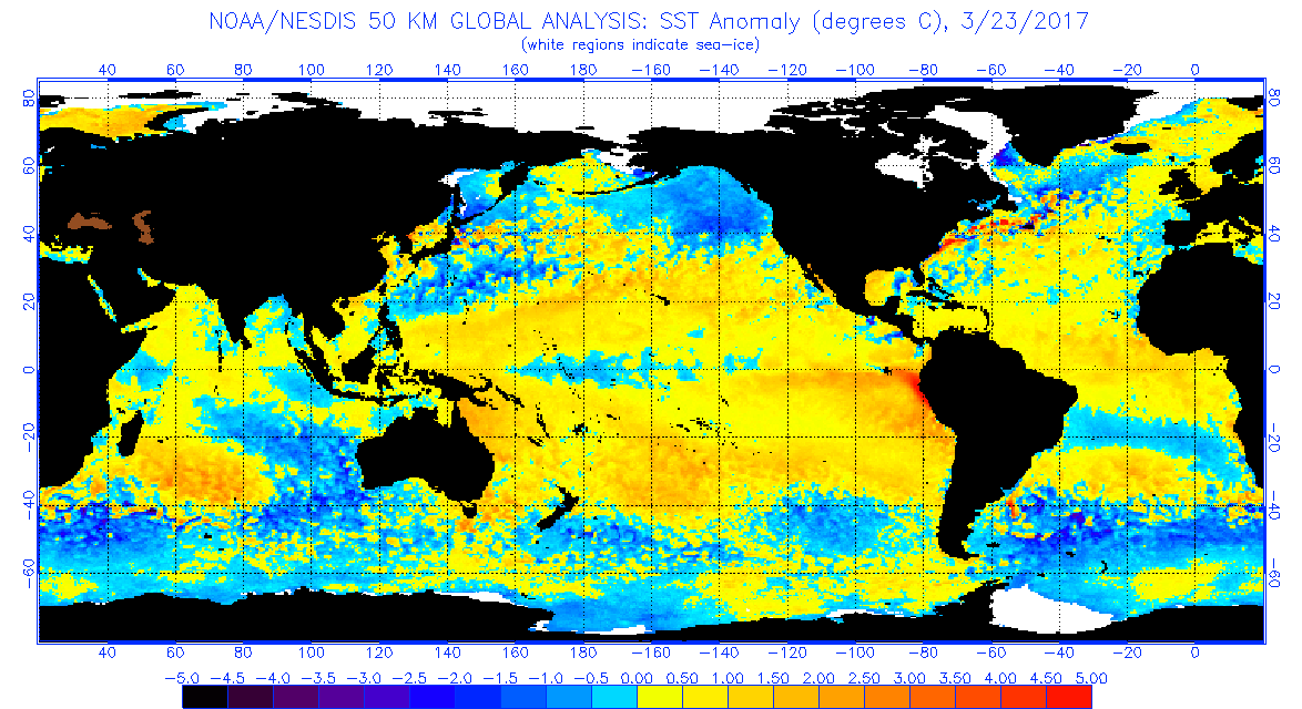
The flooding in Peru is due to the arrival of warm water along its coastline... this can sometimes herald an El Nino episode, but it is occurring in March rather than December.
As seen at www.ospo.noaa.gov/data/sst/anomaly/2017/anomnight.3.23.2017.gif
It is interesting that most of the tropical Pacific now has above normal Sea surface temperature, and there is only a small zone of cooler than normal sea near Kiribati. This cool pool is also likely to be a zone of less-than-normal rainfall.
The Tropics.
TC DEBBIE has formed in te Coral Sea and is expected to reach Cat 4 by the time it makes landfall on Tuesday along the Queensland Coast between Townsville and Bowen. Avoid.
It can be seen at www.tropicaltidbits.com/storminfo/13P_gefs_latest.png
In the Indian Ocean we have TC CALEB near Cocus island at cat 1.
The rain map at trmm.gsfc.nasa.gov/trmm_rain/Events/big_global_accumlation.gif from last week, when compared with previous week, shows continuing heavy rain around Nw and Ne Australia, the Peru coast, the Amazon, and the equatorial Atlantic. The convergence zone between Galapagos and Marquesas is one that tends to occur around this time of the year, and is still larger that the ITCZ that mirrors it in the northern hemisphere.
WEATHER ZONES
SPCZ=South Pacific Convergence zone.
SPCZ has been very active over last few days. A small tropical depression is expected to form east of Samoa on Friday local and travel southeast across Southern cooks this weekend.
The near equatorial "extra convergence zone" is expected to hang around for a few weeks.
Subtropical ridge (STR)
On Monday, the High that is currently east of the South Island is expected to migrate east and expand and reach a peak of 1030 hPa near 40S 158E on Monday.
Then another high should squeeze around southern NZ on Mon/Tue and go NE and peak at 1037hPa near 40S 160W by Thursday.
Tasman Sea troughs.
The Low west of North island tonight I expected to weaken and travel NE on Monday then south across mainland NZ on Tuesday/Wednesday/Thursday. It may bring some thundery showers, so is worth avoiding.
The remains of TC DEBBIE are expected to travel SE across the Tasman Sea on Fri/Sat/Sun, then across the North Island early next week.
Mexico to Marquesas:
The next Tehuantepec NE blast of wind near 95W is expected around 8 April.
Depending upon departure point I think the best northerly wind flow for departure this week is around Wed and Thu local this week, and after that winds may not be so good at the start.
As for waypoints: with NW to N to NE winds to Equator and then weak NE wind south of the equator, aim to take on the ITCZ between 10N 130W and Equator 135W, squalls should fade south of 5N.
Anticipate an extra convergence zone, with light winds and squalls, near 8S on the way to Marquesas.
Panama to Galapagos
Looks good for departure until 29 March with northerly winds for starters. After that winds are lighter and may be southerly. Main convection is likely between 5N and 2N.
Prepare for light winds south of 5N, maybe head for 5N 82W as a waypoint for best wind and tail current.
Galapagos to Marquesas
There is now a river of east going current between 2 and 6S west of Galapagos, hard to avoid. Maybe go to waypoints 10S 100W then 12S 125W then direct. The deviation so far to south is to avoid a counter-current and that extra convergence zone and its squalls.
The pattern is changing and may well be different in a week or so, so get updates, maybe able to cut there corners.
>>>>>>>>>>>>>>>>>>>>>>>>>>>>>>>>>>>>>>>>>>>>>>>>>>>>>>>>
See my website www.metbob.com for more information
Feedback to bob@metbob.com or txt 6427 7762212
Weathergram text only (and translator) is at weathergram.blogspot.co.nz.
Weathergram with graphics is at metbob.wordpress.com, Click FOLLOW at bottom right to subscribe.
To unsubscribe from WordPress: click the "unsubscribe" link on the bottom of the email. Or, if email wasn't from WordPress then send a reply email saying LEAVE.
>>>>>>>>>>>>>>>>>>>>>>>>>>>>>>>>>>>>>>>>>>>>>>>>>>
Followers
Translator
Bob McDavitt's ideas for sailing weather around the South pacific
26 March 2017
Subscribe to:
Post Comments (Atom)
No comments:
Post a Comment