WEATHERGRAM
YOTREPS
Compiled Sun 9 July 2017
Bob McDavitt's ideas for sailing around the South Pacific.
Disclaimer: Weather is a mix of pattern and chaos; these ideas are from the patterned world.
Last month (June)
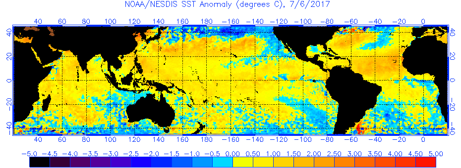
Sea Surface temperature anomalies may be seen at http://www.ospo.noaa.gov/data/sst/anomaly/2017/anomg.7.6.2017.gif
and show that there continues to be more area covered by warm anomalies than by cool anomalies. And there is still a warm river appearing along east coast of South America.
To see how the annual weather cycle and the seasons are working out, take a look at the average isobar maps from www.esrl.noaa.gov/psd/map/images/fnl/slp_30b.fnl.html
In June, the subtropical ridge in the southern hemisphere has travelled NORTHWARDS. This trend is subtle and can be seen in the isobars around NZ. The STR is strong in the Indian Ocean. Looking at the anomalies, the large continuous red area from south Indian Ocean to South Australia/NZ to east of NZ in the South Pacific, shows that the STR has been covering more latitudes than normal, and encouraging blocking highs --- explaining the dry winter in Australia.
The small green anomaly in the North Tasman Sea shows that was a favoured spot for lows to deepen in June, bringing many cyclone NE winds to northern NZ, bringing wet conditions.
The wetter than normal conditions over northern NZ also shows in the monthly rain map. This monthly rain map shows heaviest rainfall in spots from Myanmar across southern China to South Japan, and over Solomons. Last 30 days of rainfall, and its anomaly, are seen at trmm.gsfc.nasa.gov/trmm_rain/Events/thirty_day.html
TROPICS
Deluging rain associated with TC NANMADOL brought damaging landslides to Japan, with a death toll of at least 15 people. See phys.org/news/2017-07-nasa-tropical-cyclone-nanmadol-japan.html
Tonight HURRICANE EUGENE is travelling northwest off and parallel to the Mexico west coast.
Last week's rain map from trmm.gsfc.nasa.gov/trmm_rain/Events/big_global_accumlation.gif
shows an enhancement in the rain in the ITCZ over Eastern Pacific, and relaxing rain in other areas.
WEATHER ZONES
SPCZ=South Pacific Convergence zone.
The SPCZ starts this week reasonably active from Solomon Island to the Tuvalu/Tokelau area, and is expected to weaken during the week.
A passing trough, associated with a front in the Southern Ocean, is expected to go east across Rarotonga area on Tuesday UTC. Another passing trough may reach New Caledonia area around Wednesday UTC and then move onto the Tongan area on Thursday UTC and may bring some NE/N winds to Niue on Friday 14 July UTC and Rarotonga on Sat 15 UTC.
Subtropical ridge (STR)
HIGH is expected to slide southeast off Australia and into the South Tasman Sea on local Wednesday and then southeast past the south of NZ on local Friday. Another HIGH, rather weak, is expected to drift odd east Aussie on Friday local and move onto northern NZ around local Sunday 16 July.
Australia to New Caledonia:
For much of this week, this voyage is between the HIGH over Australia and low pressures over NZ, so it is mainly a disturbed SW/S/SSE flow to New Caledonia, but with wind holes in passing weak ridges.
Late in the week a trough is expected to reach Brisbane area by Sat 15 July local and that should be followed by a weather pattern offering a better sailing breeze for this trip.
Departing northern NZ to the north or east for the tropics:
On Monday, decreasing SW flow over northern NZ, and a brief break in the weather there on Tuesday may allow voyages to escape to Tonga, but not to Fiji or New Caledonia.
On Tuesday, a cold southerly is expected to reach the South Island following a trough. By Wednesday, this trough is expected to deepen into a low over the North Island and linger until it finally travels off to the east on Friday. Although this low is only being fed by southerlies from around 50S, it is cold enough to be a notable winter low with rough seas and swells over 4 sig metres north of NZ on Thursday, so may as well stay put and let it pass.
French Polynesia to the west:
There is a weak passing trough over Society Islands on 10/11 Monday/Tuesday local. This is preceded by a NW flow and followed by SE to E winds. It may be better to wait until after this trough for departure to the west.
This passing trough is likely to reach Palmerston Island by around local Monday, so wait there until local Tuesday for departure.
Another passing trough is expected to reach Niue area on local Thursday 13 July with NE winds. Avoid being there then or moor well.
If you would like more detail for your voyage, then check metbob.com to see what I offer.
>>>>>>>>>>>>>>>>>>>>>>>>>>>>>>>>>>>>>>>>>>>>>>>>>>>>>>>>
See my website http://www.metbob.com for more information
Feedback to bob@metbob.com or txt 6427 7762212
Weathergram text only (and translator) is at weathergram.blogspot.co.nz.
Weathergram with graphics is at metbob.wordpress.com,
Click FOLLOW at bottom right to subscribe.
To unsubscribe send a reply email saying LEAVE.
>>>>>>>>>>>>>>>>>>>>>>>>>>>>>>>>>>>>>>>>>>>>>>>>>>
Followers
Translator
Bob McDavitt's ideas for sailing weather around the South pacific
09 July 2017
Subscribe to:
Post Comments (Atom)
No comments:
Post a Comment