Bob McDavitt's ideas for sailing around the South Pacific.
Disclaimer: Weather is a mix of pattern and chaos; these ideas are from the
patterned world.
Compiled Sunday 29 August 2021
SPCZ The South Pacific convergence zone
The SPCZ has two main drivers:
A: HIGH "A" that is located west of South America (I call it the Andes High
because it is held in place by the Andes Mountain range). It is quasi
stationary, just like the High between California and Hawaii, and also has a
gyre that is collecting a rubbish heap just as badly especially about
Henderson/Pitcairn Islands see
blogs.fco.gov.uk/lauraclarke/2018/04/10/henderson-island-plastic-pollution-i
n-paradise/).
B: The HIGHS that migrate along around 30 South from off Australia eastwards
into the Pacific.
What is happening is that the air that rotates around HIGH "A" produces a
northeast flow over the Marquises to Tahiti area and this converges into the
south/southeasterly air flow that is produced on the leading eastern and
northern sides of the "B" Highs .
This produces a convergence zone that stretches roughly from Solomons
islands to Southern Cooks.
Things to know about the SPCZ
1: The SPCZ has an annual cycle, going more to the north in winter and more
to the south in summer.
2: It also gets tugged northwards in an El Nino and southwards in a La Nina.
3: There is a pulse of extra convections that travels eastwards along it
around once every 3 to 6 weeks calls the MJO or Madden Julian Oscillation -
powerful enough to trigger tropical cyclones during summer.
4: The strength and position of the SPCZ is constantly changing with A and
B.
5: Around once a month or so an extra strong B High with a central pressure
over 1030 hPa pushes the isobars on its north side closer together making
what I call a SQUASH ZONE of enhanced trade winds in the tropics. This
squash zone travels eastwards with the Highs. This is called Bogi walu in
Fiji or Aho Valo in Tonga or Mara'umu in French Polynesia.
6: And it can become extra squally with the help of passing troughs that
follow the migration of lows in the Southern Ocean.
Read more about it at en.wikipedia.org/wiki/South_Pacific_convergence_zone
When sailing from Tahiti to Fiji, an encounter with the SPCZ is inevitable
and may be considered as a rite of passage. The trick is to work out in
advance some waypoints that avoid its nastier parts. This requires skill
obtained from practice. Global computer models tend to average out this
convergence and show it as a misleading zone of quieter winds, whereas it
can be squally.
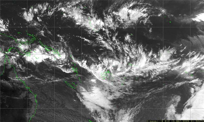
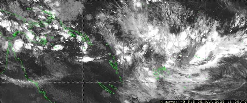
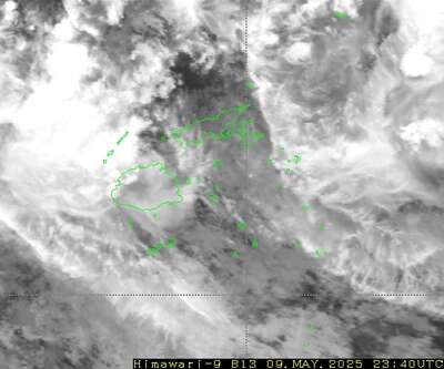
I have found that the easiest way to determine the position and severity of
the SPCZ is to watch satellite imagery (IR imagery shows the squalls). If
you can receive small sized emails at sea, you can download small sized
satellite images as follows
Send an email to query@saildocs.com (no subject needed) with one of the
following messages:
-> Infrared image 140E to 145W and from 10N to 35S updated every 10 minute
(46Kb).
SEND https://www.y2ksail.com/himawari/latest-SpacificLarge-small.jpg
-> Infrared image 140E to 160W and from 0S to 25S updated every 10 minutes
(40kb).
SEND https://www.y2ksail.com/himawari/latest-pacific3-small.jpg
-> FIJI Infrared image updated every 10 minutes (15Kb)
SEND https://www.y2ksail.com/himawari/latest-fiji-small.jpg
I recommend that you test these and check out the y2ksail.com web site
before departure from Tahiti. Also, to help decide what the SPCZ may do for
the next few says I use the 5-day rain accumulation parameter (e.g., on
windy.com)
TROPICS
Hurricane NORA is making landfall over Baja California, and Hurricane IDA is
heading for New Orleans,
after slamming Cuba. Tropical Depression TEN is heading north in mid
Atlantic.
WEATHER ZONES
SPCZ=South Pacific Convergence zone.
The SPCZ stretches from Solomona to Tuvalu to Samoa to Southern Cooks.
Trough from the southwest is expected to reach south of Southern Cooks by
mid-week and then form a low near 40S that will travel off to southeast.
HIGHS and LOWS
HIGH 1024 near 35S160W tonight is moving off to the east. High 1024 in North
Tasman Sea for Tuesday to Thursday with a squash zone of elevated trade
winds in Coral Sea strait.
LOW 1002 in mid-Tasman tonight contains thundery showers that are fading. It
is expected to travel NE to Auckland by Tuesday and then to north of NZ and
fade away by end of week.
HIGH south of NZ is expected to travel northeast and build to over 1036 east
of NZ by midweek and then to 35S 160W by end of the week. It is expected to
bring a strong squash zone between southern Cooks and southern Tonga from
the weekend. Avoid.
>>>>>>>>>>>>>>>>>>>>>>>>>>>>>>>>>>>>>>>>>
If you would like more detail for your voyage, then check metbob.com to see
what I offer.
Or Facebook at /www.facebook.com/metbobnz/
Weathergram with graphics is at metbob.wordpress.com (subscribe/unsubscribe
at bottom).
Weathergram archive (with translator) is at weathergram.blogspot.co.nz.
Contact is bob@metbob.com or txt 64277762212
>>>>>>>>>>>>>>>>>>>>>>>>>>>>>>>>>>>>>>>>>
Followers
Translator
Bob McDavitt's ideas for sailing weather around the South pacific
29 August 2021
Subscribe to:
Post Comments (Atom)
No comments:
Post a Comment