Bob McDavitt's ideas for sailing around the South Pacific.
Disclaimer: Weather is a mix of pattern and chaos; these ideas are
from the patterned world.
Compiled 27 April 2025
WESTWARD HO … for those planning to get from Tahiti to Tonga
An introduction to the South Pacific Convergence Zone (What and Why)
Now that the cyclone season finishes mid-week, many yachts are about
to travel west from Tahiti to Tonga, and are thus about to sail thru
or around the SPCZ, this obstacle has become a talking point…as if it
guards the eastern entrance to the South Pacific like a protective
dragon or demon, and some have asked what is it, why is it there, how
does it differ from the ITCZ and what makes it tick.
Weather is a mix of pattern and chaos, and meteorologists concentrate
on the pattern.
In tropical meteorology the first idea given is the Hadley cell.
Recipe for the ITCZ
Because the sun is most directly overhead near the equator, that's
where the warmest seas are, and this causes rising air.
Once the rising air reaches high enough it spreads outwards and
sideways to the north or south, where it sinks at dries out.
The sinking air reaches the surface again around 30N or 30S
(subtropical ridge) and then recirculates back to the equator as
surface winds know as trade winds.
The trade winds from each hemisphere converge together in a zone, and
this convergence narrows the zone of rising air into a feature called
the Intertropical Convergence Zone or ITCZ
But in the Southern Hemisphere, the Andes of South America cause a
split in the trade winds. They block a HIGH near 30S around 90 to
110W, or south of Easter Island. It is quasi stationary, just like
the High between California and Hawaii, and has a gyre that collects a
rubbish heap just as badly (see Henderson Island:
blogs.fco.gov.uk/lauraclarke/2018/04/10/henderson-island-plastic-pollu
tion-in-paradise/).
Recipe for the SPCZ
There are easterly winds on the north side of this "Andes" High: they
are dry due to continental outflow from off South America. These
easterly winds travel well to west of the dateline along around 10 to
15S.
And there are migratory Highs that travel east along the subtropical
ridge from Australia to east of NZ, with a zone of south to southeast
winds on their northern side. These South/SE winds come and go
according to the migratory high and are usually found around 15 to
25S.
The convergence zone between these easterly and Southeasterly winds is
called the South pacific Convergence Zone, or SPCZ.
It is typically located from the Solomon Islands south-eastwards to
the Southern Cooks, and is around 1 to 5 degrees latitude wide, but
sometimes may have large gaps or be very quiet.
It is affected by many things:
the Pacific Decadal Oscillation or PDO which takes many years to
switch.
the El Nino/La Nina which lasts a year or so.
the strongest cycle is the ANNUAL cycle as earth orbits the sun,
making the seasons.
and the MJO which comes for a week or so every six weeks or so.
Read more about it at
en.wikipedia.org/wiki/South_Pacific_convergence_zone
see www-gte.larc.nasa.gov/pem/pemt_flt.htm
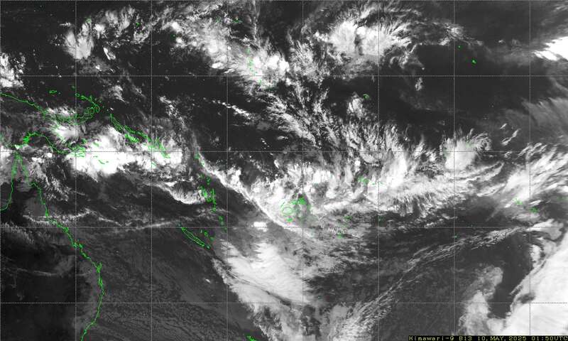
I have found that the easiest way to determine the position and
severity of the SPCZ is to use satellite imagery, and the easiest way
to decide what it may do over next few days is to use the 5day rain
accumulation parameter on windy.com.
The latest Satellite image of the SPCZ is available as a small
attachment via an email request.
Send an email to query@saildocs.com with the message (no subject line
needed)
SEND https://www.y2ksail.com/himawari/latest-SpacificLarge-small.jpg
Max puts together the Y2K links page and has recently updated it at
https://www.y2ksail.com/meteo-link.html
In a future blog I'll compare and contrast the three routes from
Tahiti to Tonga: when to take or avoid the northern, direct or
southern route and how to decide which is best over the week ahead.
NORTHWARD HO
Those gearing up to depart Northland. New Zealand for the tropics will
be often arranging a voyage across the subtropical ridge into the
tropics.
Usually, a good weather pattern to depart is in the SW flow found on
the back end of a passing trough/front/low as it moves off the east or
southeast of Northland.
However, if the following HIGH is TOO FAR south, as is the case this
week, then it may build east of New Zealand and make a squash zone of
strong east to NE winds near Tonga within a week after departure.
Avoid these departures.
TROPICS
The latest cyclone activity report is at zoom.earth and
tropic.ssec.wisc.edu and Tropical Cyclone Potential is from
www.ospo.noaa.gov/products/ocean/tropical/tcfp/
There are no named Topical cyclones around at present.
Subtropical Storm Kanto formed well to the south of Madagascar as the
first such system in the region since Issa spun up during the southern
Indian Ocean's 2021-22 cyclone season. While Kanto formed far from
land, Issa caused significant death and destruction in parts of South
Africa.
• After reaching Category-5 force for a few hours, Super Cyclone
Errol weakened to a minimal tropical storm before making landfall on
Australia
WEATHER ZONES
Wind accumulation shows windy conditions south of 30S and a squash
zone developing in Coral Sea,
Rain accumulation this week from Windy.com shows a rather weak SPCZ
and a trail of rain with L1 also a wet trough southeast of Society
Islands/Tahiti.
LOWS and HIGHS
The High H1 south of Tahiti and near 40S should exit stage right this
week and allow Low L1 which has formed off eastern New South Wales to
slowly travel east toward Northland by Tuesday and then off to the
southeast. There is a good voyage from Brisbane to Noumea riding on
the backside of L1.
Watch H2 which follows L1. It is expected to reach central Tasman Sea
this weekend. It is too far south to allow for a n easy voyage for
Northland to the tropics after L1.
Already by this weekend is expected to cause a squash zone in the
Coral Sea. And next week it may cause a squash zone or a new trough
over Tonga. There are several options and some of them allow an OK
voyage departing Northland around Wed or Thursday, but most options
don't.,
Gulf of Panama: OK Northerly winds until Wednesday then light winds.
5N to Galapagos: The convergence zone with squally showers and light
winds in-between them is from 6N to 2N. SW to S winds this week are
likely south of 3N.
Current around Galapagos are strong and this week go to the west.
Avoid the HEAD current near 5N 83W
>>>>>>>>>>>>>>>>>>>>>>>>>>>>>>>>>>>
If you would like more details about your voyage, check metbob.co
Or Facebook at /www.facebook.com/metbobnz
Weathergram with graphics is at metbob.wordpress.co
(subscribe/unsubscribe at bottom)
Weathergram archive (with translator) is at weathergram.blogspot.co.nz
Contact is bob@metbob.com or text 64277762212.
>>>>>>>>>>>>>>>>>>
Followers
Translator
Bob McDavitt's ideas for sailing weather around the South pacific
27 April 2025
Subscribe to:
Post Comments (Atom)
No comments:
Post a Comment