Bob McDavitt's ideas for sailing around the South Pacific.
Disclaimer: Weather is a mix of pattern and chaos; these ideas are from the
patterned world.
Compiled Sunday 13 June
First, a reminder that Gulf harbour radio GHR , a coastal radio station
ZMH286, run by Patricia and David, is now operating on 8752kHz or 8779kHz or
8297kHz , in that order depending on interference at (the new COVID time)
0515 UTC (1715 NZST) Monday to Friday. From 7 June they have their live
streaming service running at
www.youtube.com/channel/UCcu-iy7lVF8YiRfXCIBQ28w with a backlist of previous
seasons.
Second, those new links for the Weather Maps that I included in last week's
blog got mangled by my blog editor, so here they are again.
These are courtesy of Max from y2ksail.com, to use anyone of them send an
email to query@saildocs.com, no subject needed, with message SEND and then
the link of your choice:
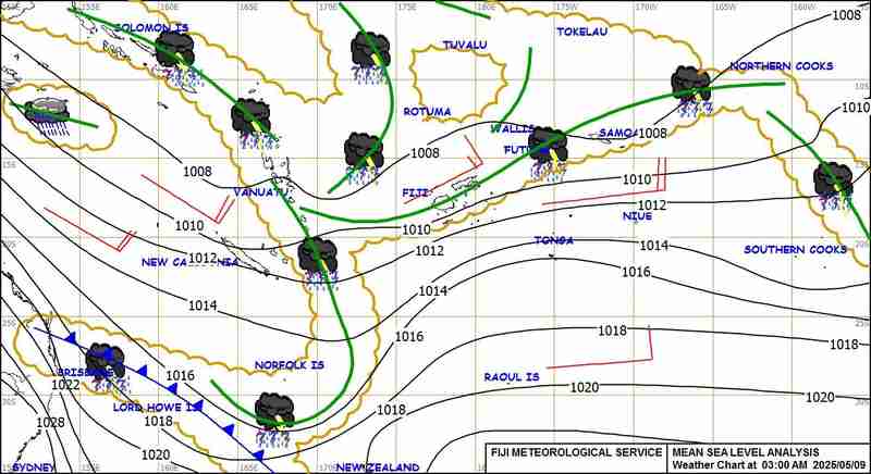
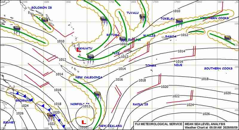
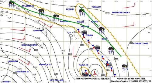
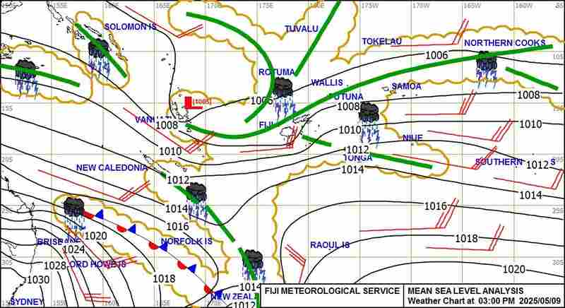
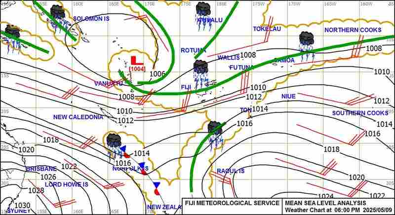
Weather Map coming from Fiji Met Service:
--> 3AM FST Surface Map available daily from 05.00am Fiji time
---> https://www.y2ksail.com/imagesfijimet/3AM-small.jpg
--> 6AM FST Surface Map available daily from 09.30am Fiji time
---> https://www.y2ksail.com/imagesfijimet/6AM-small.jpg
--> 09AM FST Surface Map available daily from 11.00am Fiji time
---> https://www.y2ksail.com/imagesfijimet/9AM-small.jpg
--> 12PM FST Surface Map available daily from 03.00pm Fiji time
---> https://www.y2ksail.com/imagesfijimet/12PM-small.jpg
--> 03PM FST Surface Map available daily from 05.00pm Fiji time
---> https://www.y2ksail.com/imagesfijimet/3PM-small.jpg
--> 06PM FST Surface Map available daily from 08.30pm Fiji time
---> https://www.y2ksail.com/imagesfijimet/6PM-small.jpg
--> 12AM FST Surface Map available daily from 03.00am Fiji time
---> https://www.y2ksail.com/imagesfijimet/12AM-small.jpg
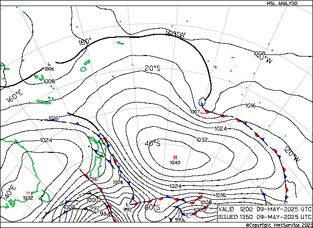
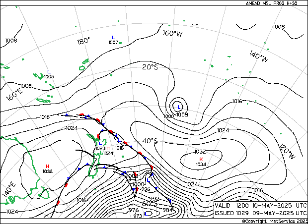
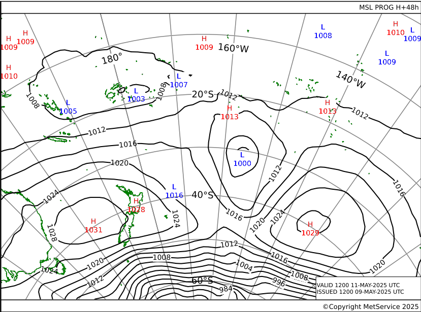
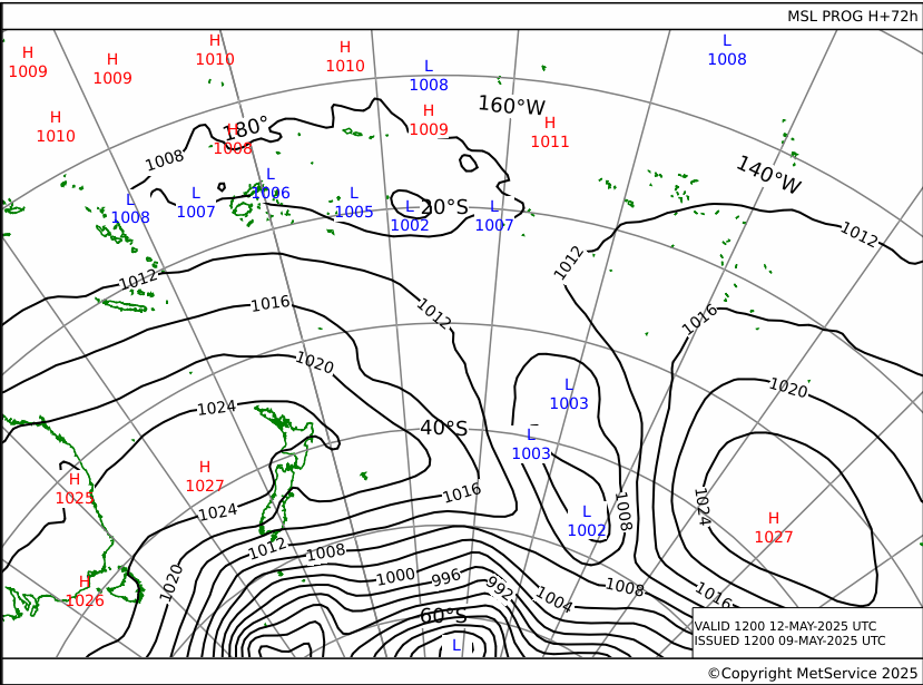
Weather Map from New Zealand Met Service update every 6 hours, normally at
02-08-14-20 UTC TIME:
--> Last Analysis Pressure chart Actual time
---> https://www.y2ksail.com/imagesnzmet/actual.gif
--> +30 hours pressure forecast chart
---> https://www.y2ksail.com/imagesnzmet/h30.gif
--> +48 hours pressure forecast chart
---> https://www.y2ksail.com/imagesnzmet/h48.gif
--> +72 hours pressure forecast chart
---> https://www.y2ksail.com/imagesnzmet/h72.gif
Thirdly, that LOW last week over Victoria, Australia, which brought
wide-spread damage from wind and rain was a polar blast, with cold air being
shoveled into the back of the LOW thanks to a HIGH well south of the
Australian Bight:
The Tropics
The latest cyclone activity report is at tropic.ssec.wisc.edu and Tropical
Cyclone Potential is from www.ssd.noaa.gov/PS/TROP/TCFP/index.html
Storm KOGUMA wakened when it made land fall in Vietnam today. TC CARLOS has
formed (today) in the East North Pacific. There is still a moderate zone of
potential development off the southwest of Mexico.
WEATHER ZONES
SPCZ=South Pacific Convergence zone.
The SPCZ is expected to be rather thin and weak, stretching from Solomon
Islands across Coral Sea to Samoa.
A trough over New Caledonia on Monday is expected to travel west and reach
Fiji/Tonga by mid-week and Southern Cooks by end of the week.
Another passing trough is expected to reach New Caledonia by end of the
week.
These troughs offer an opportunity for yachts wanting to go east, and a
challenge for those going west.
Subtropical ridge (STR)
HIGH 1030 east of NZ is travelling east along 35S. It has a squash zone of
enhanced trade winds on its northern side that will also travel east.
HIGH 1020 is expected to form in the northern Tasman Sea by Wednesday and
travel east past the north of North Island by Saturday.
Another HIGH 1020 is expected to travel northeast out of the Southern Ocean
from Monday and get southeast of South Island by Friday, feeding chilly air
onto South Island on Tuesday and Wednesday.
Aussie/Tasman/NZ troughs
LOW 1004 tonight to east of Tasmania is expected to travel east across the
South Island on Monday/Tuesday
Another low 1002 is expected to deepen to northeast of Tasmania on Thursday
and travel northeast reaching North Island by Sunday 20 June.
Typical trough/ridge inter pattern with a nearly weekly rhythm.
>>>>>>>>>>>>>>>>>>>>>>>>>>>>>>>>>>>>>>>>>
If you would like more detail for your voyage, then check metbob.com to see
what I offer.
Or Facebook at /www.facebook.com/metbobnz/
Weathergram with graphics is at metbob.wordpress.com (subscribe/unsubscribe
at bottom).
Weathergram archive (with translator) is at weathergram.blogspot.co.nz.
Contact is bob@metbob.com or txt 64277762212
>>>>>>>>>>>>>>>>>>>>>>>>>>>>>>>>>>>>>>>>>>>>>>>>>>>>>>>
Followers
Translator
Bob McDavitt's ideas for sailing weather around the South pacific
13 June 2021
Subscribe to:
Post Comments (Atom)
No comments:
Post a Comment