Bob McDavitt's ideas for sailing around the South Pacific.
Disclaimer: Weather is a mix of pattern and chaos; these ideas are
from the patterned world.
Compiled 27 April 2025
WESTWARD HO … for those planning to get from Tahiti to Tonga
An introduction to the South Pacific Convergence Zone (What and Why)
Now that the cyclone season finishes mid-week, many yachts are about
to travel west from Tahiti to Tonga, and are thus about to sail thru
or around the SPCZ, this obstacle has become a talking point…as if it
guards the eastern entrance to the South Pacific like a protective
dragon or demon, and some have asked what is it, why is it there, how
does it differ from the ITCZ and what makes it tick.
Weather is a mix of pattern and chaos, and meteorologists concentrate
on the pattern.
In tropical meteorology the first idea given is the Hadley cell.
Recipe for the ITCZ
Because the sun is most directly overhead near the equator, that's
where the warmest seas are, and this causes rising air.
Once the rising air reaches high enough it spreads outwards and
sideways to the north or south, where it sinks at dries out.
The sinking air reaches the surface again around 30N or 30S
(subtropical ridge) and then recirculates back to the equator as
surface winds know as trade winds.
The trade winds from each hemisphere converge together in a zone, and
this convergence narrows the zone of rising air into a feature called
the Intertropical Convergence Zone or ITCZ
But in the Southern Hemisphere, the Andes of South America cause a
split in the trade winds. They block a HIGH near 30S around 90 to
110W, or south of Easter Island. It is quasi stationary, just like
the High between California and Hawaii, and has a gyre that collects a
rubbish heap just as badly (see Henderson Island:
blogs.fco.gov.uk/lauraclarke/2018/04/10/henderson-island-plastic-pollu
tion-in-paradise/).
Recipe for the SPCZ
There are easterly winds on the north side of this "Andes" High: they
are dry due to continental outflow from off South America. These
easterly winds travel well to west of the dateline along around 10 to
15S.
And there are migratory Highs that travel east along the subtropical
ridge from Australia to east of NZ, with a zone of south to southeast
winds on their northern side. These South/SE winds come and go
according to the migratory high and are usually found around 15 to
25S.
The convergence zone between these easterly and Southeasterly winds is
called the South pacific Convergence Zone, or SPCZ.
It is typically located from the Solomon Islands south-eastwards to
the Southern Cooks, and is around 1 to 5 degrees latitude wide, but
sometimes may have large gaps or be very quiet.
It is affected by many things:
the Pacific Decadal Oscillation or PDO which takes many years to
switch.
the El Nino/La Nina which lasts a year or so.
the strongest cycle is the ANNUAL cycle as earth orbits the sun,
making the seasons.
and the MJO which comes for a week or so every six weeks or so.
Read more about it at
en.wikipedia.org/wiki/South_Pacific_convergence_zone
see www-gte.larc.nasa.gov/pem/pemt_flt.htm
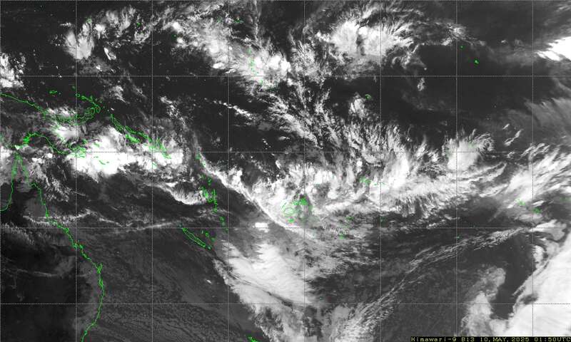
I have found that the easiest way to determine the position and
severity of the SPCZ is to use satellite imagery, and the easiest way
to decide what it may do over next few days is to use the 5day rain
accumulation parameter on windy.com.
The latest Satellite image of the SPCZ is available as a small
attachment via an email request.
Send an email to query@saildocs.com with the message (no subject line
needed)
SEND https://www.y2ksail.com/himawari/latest-SpacificLarge-small.jpg
Max puts together the Y2K links page and has recently updated it at
https://www.y2ksail.com/meteo-link.html
In a future blog I'll compare and contrast the three routes from
Tahiti to Tonga: when to take or avoid the northern, direct or
southern route and how to decide which is best over the week ahead.
NORTHWARD HO
Those gearing up to depart Northland. New Zealand for the tropics will
be often arranging a voyage across the subtropical ridge into the
tropics.
Usually, a good weather pattern to depart is in the SW flow found on
the back end of a passing trough/front/low as it moves off the east or
southeast of Northland.
However, if the following HIGH is TOO FAR south, as is the case this
week, then it may build east of New Zealand and make a squash zone of
strong east to NE winds near Tonga within a week after departure.
Avoid these departures.
TROPICS
The latest cyclone activity report is at zoom.earth and
tropic.ssec.wisc.edu and Tropical Cyclone Potential is from
www.ospo.noaa.gov/products/ocean/tropical/tcfp/
There are no named Topical cyclones around at present.
Subtropical Storm Kanto formed well to the south of Madagascar as the
first such system in the region since Issa spun up during the southern
Indian Ocean's 2021-22 cyclone season. While Kanto formed far from
land, Issa caused significant death and destruction in parts of South
Africa.
• After reaching Category-5 force for a few hours, Super Cyclone
Errol weakened to a minimal tropical storm before making landfall on
Australia
WEATHER ZONES
Wind accumulation shows windy conditions south of 30S and a squash
zone developing in Coral Sea,
Rain accumulation this week from Windy.com shows a rather weak SPCZ
and a trail of rain with L1 also a wet trough southeast of Society
Islands/Tahiti.
LOWS and HIGHS
The High H1 south of Tahiti and near 40S should exit stage right this
week and allow Low L1 which has formed off eastern New South Wales to
slowly travel east toward Northland by Tuesday and then off to the
southeast. There is a good voyage from Brisbane to Noumea riding on
the backside of L1.
Watch H2 which follows L1. It is expected to reach central Tasman Sea
this weekend. It is too far south to allow for a n easy voyage for
Northland to the tropics after L1.
Already by this weekend is expected to cause a squash zone in the
Coral Sea. And next week it may cause a squash zone or a new trough
over Tonga. There are several options and some of them allow an OK
voyage departing Northland around Wed or Thursday, but most options
don't.,
Gulf of Panama: OK Northerly winds until Wednesday then light winds.
5N to Galapagos: The convergence zone with squally showers and light
winds in-between them is from 6N to 2N. SW to S winds this week are
likely south of 3N.
Current around Galapagos are strong and this week go to the west.
Avoid the HEAD current near 5N 83W
>>>>>>>>>>>>>>>>>>>>>>>>>>>>>>>>>>>
If you would like more details about your voyage, check metbob.co
Or Facebook at /www.facebook.com/metbobnz
Weathergram with graphics is at metbob.wordpress.co
(subscribe/unsubscribe at bottom)
Weathergram archive (with translator) is at weathergram.blogspot.co.nz
Contact is bob@metbob.com or text 64277762212.
>>>>>>>>>>>>>>>>>>
27 April 2025
20 April 2025
Bobgram 20 April
Bob McDavitt's ideas for sailing around the South Pacific.
Disclaimer: Weather is a mix of pattern and chaos; these ideas are
from the patterned world.
Compiled 20 April 2025
Ten Tips for Weather Comms while Cruising South Pacific
TEN TIPS FOR CRUISING SAILORS
Now that cruising sailors are on their final preparations for
departing New Zealand for the warmth of the tropical Islands, 'tis is
a good time to review the ways to obtain weather forecasts and/or
provide position reports when at sea.
1. ZLM/Taupo Maritime Radio offer a continuous 7/24 Trip
reporting service, see
www.maritimenz.govt.nz/about/what-we-do/safety-and-response/maritime-r
adio.asp
The HIGH SEAS forecast for the area SUBTROPIC from MetService is read
out in English via ZLM at 0903hr, and 2103hr NZST/NZDT on 6224 and
12356KHz and repeated an hour later on 8297 and 16531 KHz.
(www.metservice.com/marine/radio-schedule)
NZ MetService ceased their ZKLF Radio fax 1 July 2023
Australia's Bureau of Meteorology still sends weather maps by HF Radio
fax. The nearest transmitter to the South Pacific is VMC in
Charleville, schedule is at
www.bom.gov.au/marine/radio-sat/radio-fax-schedule.shtml
2. Gulf Harbour Radio ZMH286 check in service with weather.
Patricia and David keep track of boats that listen to their
rollcall/weather service. Firstly, contact them via email or radio
with your details - boat name, MMSI, boat type and length. Then let
them know when you are about to take off and whether you will be on
air each night. They operate on 8752USB at 0515 UTC which is 5:15pm
NZST and an hour later during daylight saving, 6:15pm. Each broadcast
is live streamed so friends and family can hear your check in and
follow along. David gives a weather update each night for the passage
routes and the islands. And there are articles of general interest and
specifically on weather in their web site, www.ghradio.co.nz
ghradio@xtra.co.nz
3. Passage Guardian passageguardian.nz
peter@passageguardian.nz
Passage Monitoring is operated by Peter Mott and provides a global
free-of-charge service (donations welcome) that monitors the progress
of recreational vessels conducting ocean passages.
Peter uses a range of tools, including satellite trackers, AIS and
email, and multiple maritime radio frequencies to keep a constant
watch on yachts that have filed a float plan prior to departure. The
service has a formal policy for dealing with a missed check in.
Whilst available to all yachts, Passage Monitoring is especially
suited to shorthanded and solo sailors, in particular
circumnavigators.
4. AMATEUR RADIO/Ham net: PACSEANET pacseanet.gmail.com
The Pacific Seafarers Net is a ham (amateur radio) network providing a
free of charge check in service on amateur frequency 14300KHz USB in
the 20-metre band at 0300UTC. To participate, operator needs to hold
an Amateur Radio Operators Certificate (General class or above). In
the amateur radio service, the callsign is assigned to the licensed
operator, so this is a different callsign from using a maritime
callsign. Position reports are received and reported in the well-know
YOTREPS format (but missed calls may not be followed up). They have 12
listening station dotted between Australia and Alabama. See
pacseanet.blogspot.com
5. EMAIL via HF requires a PACTOR modem See
https://sailmail.com/
6. INTERNET via EMAIL
if you only have email, Saildocs (saildocs.com) relays details of a
TEXT BASED webpage. See weather.mailasail.com/Franks-Weather/Home
They allow you to download, e.g., the latest Fiji Met Service High
Seas by sending an email, no subject necessary, to query@saildocs.com
with message: SEND http://www.met.gov.fj/aifs_prods/10140.txt
For a list of useful links see https://www.y2ksail.com/meteo-link.html
7.. Fiji Fleet code. How to download a map via HF (thru email)
This is real old school stuff, but it still works if you need it.
To download the latest Nadi Fleet Code, send an email to
query@saildocs.com, no subject needed, saying SEND nadi-fleetcode
Or SEND https://tgftp.nws.noaa.gov/data/raw/as/asps20.nffn.txt
This can be viewed within the Fleet Code plug in OpenCPN.
Download this at opencpn.org/OpenCPN/info/downloadopencpn.html
Open the email and select and copy the data (right click, Contral A
then Control C on a PC). Then, in OpenCPN's Fleet code plugin, there
are 4 options: Files, Text, Raw and Downloads. Select Raw and then
<paste> or CTRL-V and Voila! the map appears.
I still have a copy of the old, no longer supported Fleet code viewing
program call Phys Plot. If you want to try it, let me know.
8. Smart phone apps: Some satellite phones now provide Wi-Fi that
allow nearby smart phones to use apps.
www.predictwind.com provides an app that supplies forecast model
data, observations and, at the Professional Account level, tools for
routing and comparing departure dates. It also has a position
tracking tool and can help with iridium Go! and some other GPS
devices. A moderate subscription gives access to its universal AIS
package with a regional search option.
9. The Windy.com App has a free basic option. It also has a
subscription option that can be used to compile route plots.
To make one: - "right click" anywhere on the map, this will open a
small context window. - choose "Distance & Planning"; - place your
points on the map; chose 'Boat' and enter your average likely speed,
click on "more options" bottom left and in the "table of points" you
just made, click the button label "share" in the bottom right corner;
- remember and use the short URL link provided or the long URL in the
top of your browser. You can also make one by building the URL
manually if you are familiar with this. Each time you plug this URL
in your browser, Windy will show the map and your planned route.
Shift the start time to see which gives the best voyage.
10. YiT, Yachts in Transit, at www.yit.nz or mike@yit.nz has a
smart phone app, and offers a subscription service to plot your
reports and blogs on the web and to request weather information via
coded emails. They also provide info on how to use iridium Go!, YB
Tracking, or Garmin inReach for communications. This site was closed
for a while but is back again this year.
TROPICS
The latest cyclone activity report is at zoom.earth and
tropic.ssec.wisc.edu and Tropical Cyclone Potential is from
www.ospo.noaa.gov/products/ocean/tropical/tcfp/
There are no named Topical cyclones around at present. Tropical
Depression 31 is heading for top end of Queensland.
Cyclone Errol exploded in strength to Category-4 force between Bali
and northwestern Australia. It drifted southeast-ward and weakened
before striking the Australian coast near Broome during the following
week. Tropical Storm Tam drenched much of the Vanuatu archipelago
without inflicting significant damage. But its remnants later knocked
out power and triggered local flooding across New Zealand's North
Island.
WEATHER ZONES
Weather Zones Mid-week GFS model showing isobars, winds, waves
(purple), rain (red), MT (Monsoonal trough), STR (Subtropical Ridge),
SPCZ (South Pacific Convergence Zone) CZ (Convergence Zone)
Wind accumulation shows a demarcation line along the SPCZ. Also, the
track of L1 leaves a wind trail.
Rain accumulation this week from Windy.com shows heaviest rain may be
near northern Australia and along the SPCZ. A dry slot between BZ and
Fiji/Tonga.
LOWS and HIGHS
The remains of Cyclone TAM are finally moving across N Z on Monday.
The High H1 south of Tahiti and near 35S is quasi-stationary this
week and shepherding a small Low L1 from near Kermadecs southwards
then southeast-wards bringing a southerly flow to NZ on Tuesday, an OK
pattern for departing Northland for Fiji/Tonga.
However, by mid-week small lows on the SPCZ may form, L2 near southern
Cooks and L3 near Vanuatu.
L3 can make for stronger E to NE winds in area north of NZ by the
weekend so if you are unable to make a Tuesday departure from NZ then
for comforts sake it may be better to wait for next agreeable pattern
High H2 from Aussie Bight is expected to cross southern Tasman Se and
central NZ on Thursday and Friday then build east of NZ this weekend
with a squash zone on its northern side.
Gulf of Panama: Light winds until local Monday then useful NE winds
for several days
5N to Galapagos: The convergence zone with squally showers and light
winds in-between them is from 6N to 2N. Light south to southeast winds
around Galapagos.
Current around Galapagos is mainly from SE. Avoid the HEAD current
near 5N 83W
>>>>>>>>>>>>>>>>>>>>>>>>>>>>>>>>>>>
If you would like more details about your voyage, check metbob.com
Or Facebook at /www.facebook.com/metbobnz/
Weathergram with graphics is at metbob.wordpress.com
(subscribe/unsubscribe at bottom).
Weathergram archive (with translator) is at
weathergram.blogspot.co.nz.
Contact is bob@metbob.com or text 64277762212.
>>>>>>>>>>>>>>>>>>>>>>>>>>>>>>>>>>>>>
13 April 2025
Bob blog
Bob McDavitt's ideas for sailing around the South Pacific.
Disclaimer: Weather is a mix of pattern and chaos; these ideas are
from the patterned world.
Compiled 13 April 2025
Recorded Natural disasters
The International Disaster database EM-DAT of the Centre for Research
on the Epidemiology of Disaster (CRED) gives a graph like this since
1900
As seen at https://ourworldindata.org/disaster-database-limitations
However the reporting system in the 1900s was insufficient. so if we
just concentrate on the past 23 years ...
...then we see that there is a reasonably constant trend.
The good news is that, thanks to improvements in forecasting, alerting
and warning, the number of human deaths had a drop to below 50,000 per
year between 2011 and 2121 ....In 2022 there was a European heat wave
and in 2024 some earthquakes jolted the numbers up.
TROPICS
There are no named Topical cyclones around at present.
But that system forming near Vanuatu has potential.
WEATHER ZONES
Weather Zones Mid-week GFS model showing isobars, winds, waves
(purple), rain (red), MT (Monsoonal trough), STR (Subtropical Ridge),
SPCZ (South Pacific Convergence Zone) CZ (Convergence Zone)
Wind accumulation shows the full extent of the Tasman Easter Low.
Also, some windy lows in the tropics about Australian north coast this
week.
Rain accumulation this week from Windy.com shows heaviest rain may be
near northern Australia. Also shows the rain trail of L2 in the Tasman
Sea.
LOWS and HIGHS
On Monday the front attached to Low L1 is expected to cross South
Island and then L1 should move off to the southeast.
High H1 is the Tasman Sea is expected to follow L1 and scoot around
the south and east side of South Island on Tuesday.
Clouds are gathering around Vanuatu on Monday in a tropical Low L2
that should then move south into the Tasman Sea. Here it is expected
to ingest cold air that has arrived fresh from the Southern Ocean on
the back side of L1. The squashing isotherms are expected to help
deepen L2 from 1000 on Tuesday to 980 on Wednesday bringing wind and
rain to NZ just in time for the starting commute of the Easter holiday
break. Avoid
HIGH H2 is expected to travel across New South Wales at end of the
week and into Tasman Sea as L2 crosses central NZ.
Them Low L3, near Tasmania on Friday combines with another low and
moves across Tasman Sea next week. Possibly avoid. This means that
the following 10 days are difficult for trans-Tasman travel
Gulf of Panama: Useful NE winds until Thursday 17 the showery on Good
Friday and light winds next week.
5N to Galapagos: The convergence zone with squally showers and light
winds in-between them is from 5N to 2N. Light southerly winds around
Galapagos and the current at the equator is to the NW.
>>>>>>>>>>>>>>>>>>>>>>>>>>>>>>>>>>>
If you would like more details about your voyage, check metbob.com
Or Facebook at /www.facebook.com/metbobnz/
Weathergram with graphics is at metbob.wordpress.com
(subscribe/unsubscribe at bottom).
Weathergram archive (with translator) is at
weathergram.blogspot.co.nz.
Contact is bob@metbob.com or text 64277762212.
>>>>>>>>>>>>>>>>>>>>>>>>>>>>>>>>>>>>>
06 April 2025
Bobgram
Bob McDavitt's ideas for sailing around the South Pacific.
Disclaimer: Weather is a mix of pattern and chaos; these ideas are
from the patterned world.
Compiled 6 April 2025
MJO/ Madden Julian Oscillation
A quiet phase of the MJO is expected over the next few weeks, and this
should help keep the South Pacific Convergence zone in a mellow mood
and reduce the risk of a late season cyclone.
Here is the latest constructed analogue forecast for the MJO
Basically, in these maps: blue mean "bubbly" and yellow means "mellow"
TROPICS
The latest cyclone activity report is at zoom.earth and
tropic.ssec.wisc.edu and Tropical Cyclone Potential is from
www.ospo.noaa.gov/products/ocean/tropical/tcfp/
There are no named Topical cyclones around at present.
WEATHER ZONES
Weather Zones Mid-week GFS model showing isobars, winds, waves
(purple), rain (red), MT (Monsoonal trough), STR (Subtropical Ridge),
SPCZ (South Pacific Convergence Zone) CZ (Convergence Zone)
Rain accumulation this week from Windy.com shows heaviest rain may be
near northern Australia. Also, with SPCZ to SE of New Caledonia.
Wind accumulation this week from Windy.com
The wind accumulation shows some wind zones with L1. Also, a small
squash zone near Kermadecs and between Niue and Aitutaki this week.
LOWS and HIGHS
Low L1 and associated troughs crossing NZ on Monday and Tuesday
followed by a cold southerly flow on Wednesday.
HIGH H1 south of Tahiti is expected to fade away late in the week.
HIGH H2 is expected to travel east across Bass Strait on Monday and
then the Tasman Sea and reaching central NZ from Thursday to the
weekend, with a small squash zone on its northern side.
Gulf of Panama: Useful NE winds and showery.
5N to Galapagos: Light winds often from behind. Good tail currents
on the direct route. Showery especially south of 2N.
>>>>>>>>>>>>>>>>>>>>>>>>>>>>>>>>>>>
If you would like more details about your voyage, check metbob.com
Or Facebook at /www.facebook.com/metbobnz/
Weathergram with graphics is at metbob.wordpress.com
(subscribe/unsubscribe at bottom).
Weathergram archive (with translator) is at
weathergram.blogspot.co.nz.
Contact is bob@metbob.com or text 64277762212.
>>>>>>>>>>>>>>>>>>>>>>>>>>>>>>>>>>>>>
Subscribe to:
Comments (Atom)